Extractive
Summary of Dominant Character
This zone contains all extractive sites operative in 2003, when characterisation was underway. By far the largest scale extractive operations in the zone at this time were the massive collieries at Orgreave and Maltby Main. Of the other character areas, only ‘Harry Croft Quarry’ is larger than a few hectares. Active extractive landscapes are, by their nature, highly dynamic - their raison d’être being to remove the physical mass of the land for the purposes of its economic exploitation. Common features of such extractive landscapes are voids in the countryside, spoil and stock heaps, processing buildings and plant.
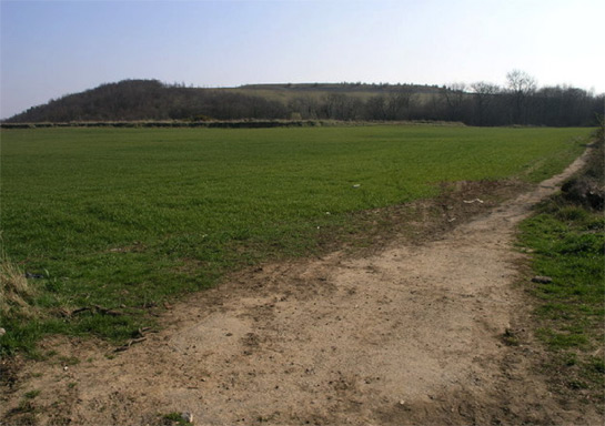
Figure 1: Spoil heaps at Maltby Main Colliery.
© Michael Patterson, some rights reserved- used under a ‘creative commons’ licence (http://creativecommons.org/licenses/by-sa/2.0/)
Relationship with Adjacent Character Zones
This zone is generally found adjacent to the settlements where the workers are, or were, housed. There is a time based relationship between this zone and the ‘Post Industrial’ character zone, as there are strong forces of change in the borough acting to promote the reuse of disused extractive sites for reuse as recreational and commercial sites. The zone only represents a very small proportion of the land in the Rotherham district that has been characterised as having extractive activity - the majority having closed down and been subject to re-landscaping prior to 2003.
Inherited Character
The nature of the activities at these sites means that, beyond traces of their earlier development as extractive landscapes, previous historic character is generally invisible having literally been mined away. The inherently destructive nature of mining and other extraction on the past landscape means that this section will concentrate on a brief history of the extractive landscapes of this zone themselves.
The Middle and Upper Coal Measures are the dominant geology within the Rotherham district. These rocks hold valuable coal and clay seams that dip down from the west to the east. The thickest deposits of coal run along the centre of the Coal Measures, with one of the most productive seams being the Barnsley Bed. Further east the seams thin and dip further underground, until the coalfield runs beneath the Magnesian Limestone (Hill 2002, 14).
The shallow outcrops in the west of the district made the seams there accessible from an early date, with Hill (2002, 16) citing shallow mining at Masborough in the thirteenth century and more widely across the district by the 16th and 17th centuries. Most of these early coal mines will not have been individually recorded by the characterisation project because of the small impact they made on the surrounding landscape, but they were an important part of the development of the coal industry. By the middle of the 19th century collieries in the west of the coalfield were beginning to become exhausted and advances in technologies of transport, ventilation and pumping were beginning to make the exploitation of the deeper seams, through deep shaft mining, a reality (ibid, 16).
Early collieries recorded by this project typically date to the first half of the 19th century, closing in the late 19th or early 20th century, and include, Jordan, Grange, Fence, Greaves, Holmes and Warren Vale collieries. These collieries were often clustered close together in areas with a long history of surface or near surface mining. Later collieries established in the early twentieth century, such as Dinnington and Thurcroft, have more in common with those in the Doncaster district, and are spaced further apart, reflecting the deeper depth of their shafts and the wider royalties1 that were required to make them economically viable.
The reorganisation of the coal industry in the 1970s and 80s led to many pits closing or combining with other nearby collieries and by the 1990s there were only 3 deep coal mines active in the district - at Dinnington, Thurcroft and Maltby. After closure, the colliery buildings were sometimes immediately pulled down, but the large spoil heaps around the collieries are often left as dominant features in the landscape.
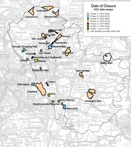
Figure 2: The dates of closure of Rotherham shaft mined collieries large enough to register as character units. N. B. During the time of this project Orgreave and Silverwood were operating as opencast coal sites.
Underlying mapping © Crown copyright. All rights reserved. Sheffield City Council 100018816. 2007
Opencast coal mining was still an active process within the borough during the life of this project, with extraction taking place at Orgreave (which closed as a shaft mine in 1981). This extraction, which began in 1995, necessitated the removal of a landscape that included the 17th century Orgreave Hall (SYAFRU 1995) in addition to much of the site of one of the most contested confrontations of the 1984-85 miners strike, known as ‘The Battle of Orgreave’ (Hunt 2006). This event began at the gates of a coking works being picketed by striking miners, within the ‘Orgreave Colliery’ character area. As the confrontation escalated, the police deployed mounted and (for the first time on the UK mainland) ‘short shield’ squads - resulting in the flight of many of those picketing into Orgreave village, with the police in pursuit (ibid).
Outside this zone a number of other now ‘restored’ opencast sites have been recorded within the ‘Surveyed Enclosure’ and ‘Private Parkland’ zones. This type of mining began in 1942 with the creation of the Directorate of Opencast Coal and subsequent mining activities on the Flockton, Whinmoor and Fenton coal seams (Gray 1976, 41).
Later Characteristics
The highly recent nature of the activities within this zone means that there has been little opportunity for later additions to the landscape. Former collieries within the zone are moving towards ‘Post Industrial’ landscapes, with the reclamation of spoil heaps, planting of trees and addition of new roads to facilitate the creation of business parks. The 1990s was a time of significant change for former extractive sites, with financial support, such as European Objective 1 funding, coming into the region for regeneration of both towns and countryside. This means that the vast majority of former collieries are now within the ‘Post Industrial’ zone.
Opencast coal mining has ceased in the district since the initial characterisation survey was undertaken - the last coal being taken from Orgreave in 2006.
Character Areas within this Zone
Map links will open in a new window.
- Former Kilnhurst Brickworks (Map)
- Harry Croft Quarry, South Anston (Map)
- Maltby Main Colliery (Map)
- Orgreave Colliery (Map)
- Quarry Lane, Masbrough (Map)
Bibliography
- Gray, G.D.B.
- 1976 The South Yorkshire Coalfield. In: J. Benson and R.G. Neville (eds.), Studies in the Yorkshire Coal Industry. Manchester University Press, 31-44.
- Hill, A.
- 2002 The South Yorkshire Coalfield: a History and Development. Stroud: Tempus Publishing Ltd.
- Hunt, T.
- 2006 The Charge of the Heavy Brigade. The Guardian, Monday, September 4th, 2006.
- SYAFRU (South Yorkshire Archaeology Field and Research Unit)
- 1995 Results of a First and Second Stage Archaeological Evaluation: Orgreave Hall and Curtilage [unpublished]. SYAFRU for RJB Mining.
1Royalties were the rights to extract coal from beneath land. A colliery with extensive ‘royalties’ was one where the operators had secured rights from landowners to extract from a wide area around the pit head (Hill 2002, 8).