Post Industrial
Summary of Dominant Character
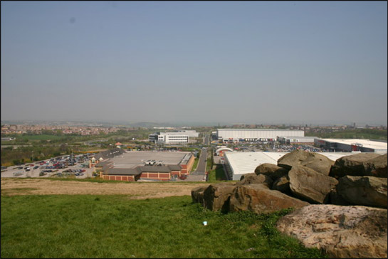
Figure 1: Cortonwood Retail Park - typical late 20th century warehouse retail development, on the site of the former Cortonwood Colliery.
© Jeff Pearson used according to a creative commons licence - http://creativecommons.org/licenses/by-sa/2.0/
This zone is characterised by landscapes formed since the mid 1970s, during which period the county has undergone a large scale transformation in its employment base - from an economy based overwhelmingly on traditional heavy industries, such as the extraction of coal and the manufacture and processing of steel, to one in which retail, leisure and other service industries play a much greater part (Munford 2003, 149). These changes have resulted in substantial changes in historic character within this zone, particularly where formerly industrial or extractive sites have gone out of use and been cleared for redevelopment.
Typical land uses associated with this zone include: commercial complexes, typically housed in prefabricated buildings (often large sheds used for warehousing and distribution), or modernist office complexes housing administrative or ‘contact’ (call centre) facilities; ornamental or recreational parklands, characterised by young plantation woodlands, grassed areas and artificial lakes (generally found on post-extractive sites); retail complexes consisting of large warehouse type sheds associated with large areas of car parking; and finally (and often on former agricultural land rather than post industrial land), large transport infrastructure features such as motorway junctions and associated service areas. Sites where industrial or extractive activities have ceased and structural remains have been cleared without the clear implementation of a new management regime (by the time of the characterisation study) have been included within this zone. These sites are generally characterised by scrub vegetation, spoil heaps, slurry ponds and rubble.
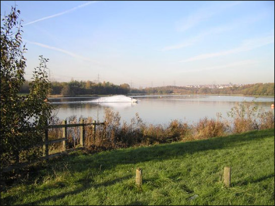
Figure 2: A jet-ski cuts across an artificial lake created by the deliberate flooding of a former opencast coal extraction site, at ‘Rother Valley Country Park’.
© Copyright David Morris and licensed for reuse under this Creative Commons Licence http://creativecommons.org/licenses/by-sa/2.0/
Relationships with Adjacent Character Zones
This zone is widely distributed across Rotherham borough and is largely built on areas of former coal mining, although there is also a strong relationship with the flood plains of the rivers Don and Rother. As a result, there are close relationships with areas of ‘Industrial Settlements’ and ‘Planned Industrial Settlements’, which will have housed the work force at these former collieries and other industrial sites. The improvement of these settlements is often the driving force for the redevelopment of these former industrial sites, either to improve the quality of the landscape around towns or to bring new employers into the area.
Inherited Character
The redevelopment of former industrial and coal mining areas is often specifically designed to remove elements of the former landscape, as part of land reclamation regimes seeking to improve the countryside. However, the large scales of the spoil heaps that developed alongside these mines in the mid to late 20th century can sometimes defy removal without very substantial earth moving operations. This means that, despite considerable alteration of the land through landscaping, planting of trees and grasses, and the removal of colliery buildings, many of the sites within this zone have significant historic legibility of their coal mining past.
The Middle and Upper Coal Measures are the dominant geology within the Rotherham district. These rocks hold valuable coal and clay seams that dip from the west to the east. Further east the seams thin and dip further underground until the coalfield runs beneath the Magnesian Limestone, west of Doncaster (Hill 2002, 14).
The former collieries within this zone were often first worked in the mid to late 19th century, as advances in technologies of transport, ventilation and pumping were beginning to make the exploitation of deeper coal seams a reality. These mines were subject to significant expansion until the mid 20th century. The reorganisation of the coal industry in the 1970s and 80s led to many pits closing or combining with other nearby collieries and by the 1990s there were only small numbers of active pits in the district. After closure the colliery buildings were sometimes pulled down immediately; rare examples of the range of the pit head structures to be found at these mines can still be seen at Kiveton. Pit wheel monuments also provide legibility of the past mining landscape.
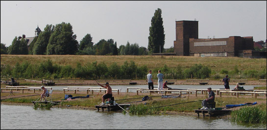
Figure 3: Fishing ponds on the site of Kiveton Park Colliery (closed 1994). Most of the site was flattened following closure, although the Grade II listed 1877 colliery offices (top left behind trees) and 1938 pit-head baths survive.
© Xurble - licensed for reuse under a creative commons licence http://creativecommons.org/licenses/by-sa/2.0/
The nature of the former activities at these sites means that beyond traces of their earlier development as extractive landscapes, previous historic character is generally invisible - having literally been mined away. One exception to this rule is at Bedgreave Mill, which was retained as a centrepiece for Rother Valley Park and heavily restored for that purpose in 1983. The mill now forms an island of legibility surrounded by the site of former opencast extraction – the river Rother on which it once stood has been diverted into an artificial channel to the east.
A similar pattern of character transformation is visible at the ‘Northgate and Parkgate’ character area, now largely occupied by the late 20th century Parkgate Business Park, Barbot Hall Industrial Estate, and Parkgate Retail World developments. These developments represent the regeneration of enormous areas formerly occupied by the Park Gate Iron and Steel Co (Munford 2003, 78-90) and the South Yorkshire Chemical Works. Very little survives of these earlier industrial landscapes.
Later Characteristics
As this zone is typified by much of the most recent developments to affect the Rotherham landscape it is perhaps best to consider it as a growing character zone, highly likely to expand over the next decade. During the life of this project regeneration work has continued at most of the former colliery sites within this zone, most notably in the establishment of community woodlands and nature reserves.
Character Areas within this Zone
Map links will open in a new window.
- Bradgate Post Industrial (Map)
- Catcliffe Post Industrial (Map)
- Central Post Industrial (Map)
- Cortonwood Colliery Site (Map)
- Dalton Post Industrial (Map)
- Dinnington Main Colliery Site (Map)
- Former Royal Ordnace Factory, Maltby (Map)
- Grange Colliery Site (Map)
- Grange Lane, Brinsworth (Map)
- Hellaby Industrial Area (Map)
- Ickles Post Industrial (Map)
- J33 Post Industrial (Map)
- Kilnhurst Post Industrial (Map)
- Kiverton Park Colliery (Map)
- Kiverton Park Quarries (Map)
- M1 M18 Junctions (Map)
- Manvers Main Colliery Site (Map)
- Netherthorpe Airfield (Map)
- New Stubbin Colliery Site (Map)
- Northfield and Park Gate (Map)
- North Staveley and Waleswood Colliery Site (Map)
- Rotherham Main Colliery Site (Map)
- Rother Valley Country Park (Map)
- Roundwood and Aldwark Colliery Sites (Map)
- Silverwood Post Extractive (Map)
- Site of Kimberworth Colliery (Map)
- Spoil Heaps, Jordan (Map)
- Swinton Bridge Post Industrial (Map)
- Thurcroft Main Colliery Site (Map)
- Wath Main Colliery Site (Map)
- Wickersley Post Industrial (Map)
Bibliography
- Hill, A.
- 2002 The South Yorkshire Coalfield: a History and Development. Stroud: Tempus Publishing Ltd.
- Munford, A.
- 2003 Iron and Steel Town: An Industrial History of Rotherham. Stroud: Sutton Publishing Ltd.