Industrial
Summary of Dominant Character
This zone can be split into two quite different landscapes. One is the inactive sites that still display significant characteristics of former industrial activity, with surviving buildings and boundaries. These sites tend to date from the late 18th or 19th centuries, although some developed from early post-medieval or medieval origins, particularly where early use involved the exploitation of water power.
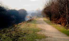
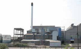
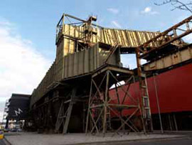
Figure 1: Varied industrial landscapes in this zone. Clockwise from top left: a) Part of the former towpath of the 1751 Sheffield to Keadby Canal near Jordan; b) 20th century glassworks complex at Beatson Clarke, Thorn Hill, Rotherham; c) Part of the ‘Magna Centre’ formerly the 20th century melting shop of Steel, Peech and Tozer at Templeborough; and d) part of the Effingham Works, a former stove grate founders on Thames Street, Rotherham.
a), c) and d) © Steve Fareham licensed for reuse under a creative commons licence http://creativecommons.org/licenses/by-sa/2.0/
The other are more recent 20th century industrial concerns, with larger industrial buildings associated with chimneys, tanks and containers. These sites were generally active in 2003, when characterisation was underway. Late 20th century industry is generally only included within this zone when the buildings are part of an earlier industrial concern that has continued in use and been rebuilt.
The oldest surviving industrial buildings in this zone are likely to be brick built, with one or more narrow ranges - ensuring good natural lighting to the working areas within. Surviving examples of such industrial architecture are rare but include the Effingham Works, Thames Street, built for Yates and Haywood (stove grate manufacturers) in the 1880s (Munford 2003, 62) and the surviving buildings of Guest and Chrimes (brass founders and manufactures of valves) on Don Street, built in 1857.
The majority of surviving industrial architecture in this zone dates to the mid 20th century or later. This is even true of sites with a long industrial history, such the site of Beatson Clark’s glassworks on Glasshouse Street, where glass making has been recorded since the establishment of a works in 1769, by John Wright in partnership with Aaron Walker (Munford 2003, 111). However, the characterisation database reveals that the present arrangement of buildings on the site is first depicted on OS mapping in the mid 1980s and is only the most recent of a number of rebuilding phases.
The largest and most dramatic architecture in this zone is to be found at sites connected with the manufacture and processing of steel in the 20th century. The character areas that most exemplify this theme are ‘Roundwood, Aldwark and Thrybergh Steelworks’ and ‘Templeborough and Ickles Heavy Industries’. These character areas are typified by very long (300-600m) and large 20th century sheds clad in metal sheets and linked by travelling cranes, industrial railways, gantries and conveyors. These buildings were built to house processes such as the electric arc production of steel, its casting into ingots and processing by rolling into bars or sheets.
Relationship with Adjacent Character Zones
The ‘Industrial’ zone has a key relationship with surrounding settlement areas. Industrial activities require a workforce. Sometimes workers will be drawn to an area by the promise of work or conversely the industry will develop near to an existing population centre. The ‘Industrial Settlements’ and ‘Grid Iron Terraced Housing’ zones are settlements that have been specifically developed alongside local industries. The majority of housing in these zones was constructed using mass produced materials, often to designs that aimed to provide the cheapest housing possible within legislative restrictions (Gaskell 1987, 50; Newman 2001, 93-99).
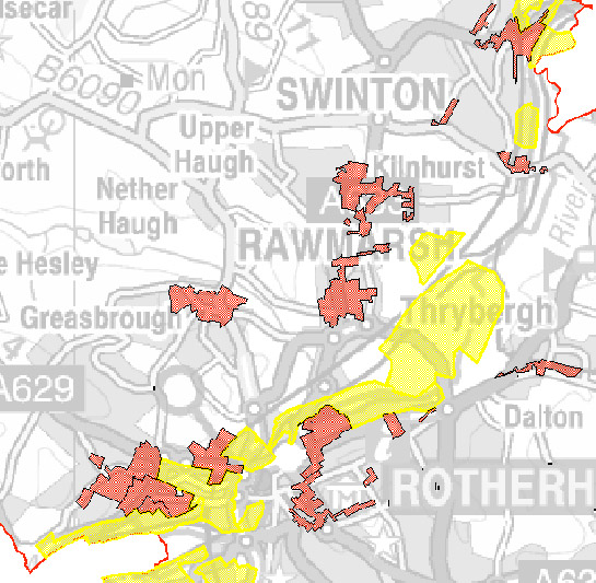
Figure 2: The location of the ‘Industrial’ zone (yellow) is closely related to the distribution of the ‘Grid Iron Terraced’ and ‘Industrial Settlements’ zones (both shown in red).
© Crown copyright. All rights reserved. Sheffield City Council 100018816. 2007
The distribution of this zone is principally around the valley floors of the rivers Don and Rother. This distribution has been influenced not only by the historic use of water power within the metal trades (see for example Ball et al 2006) but also by the presence of large areas of flat land, within the alluvial flood plain, close to canal and railway transport links. The improvement in communications to both Rotherham and Sheffield, along the canal network, played an important part in the development of early industry in the district. Communications were further improved by the construction of the Manchester, Sheffield and Lincolnshire Railway along a similar route in the mid 19th century. This communication corridor allowed both the import of raw materials and the export of finished goods to a wider market. The figure below indicates the location of land recorded within the project database with industrial character, by the time of the 1891 OS mapping of the district, and its close relationship with the communications network. This figure also demonstrates the wide variety of then active industries, in addition to those directly connected to the metal trades.
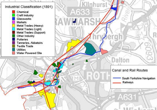
Figure 3: HEC Broad Types of industrial character in 1891, shown in relation to contemporary rail and canal systems.
Modern mapping © Crown copyright. All rights reserved. Sheffield City Council 100018816. 2007
There are a number of industrial sites that are not included within this zone. The majority of these sites fall within the ‘Post Industrial’ zone and consist of industrial developments within large business parks that have often developed on areas of former coal extraction. These late 20th century industrial sites generally consist of plain shed-like buildings and are often mixed with commercial retail developments and large offices. The building style of these industrial sites is not always significantly different to that of the adjoining commercial sites - in part due to a changing emphasis away from large-scale heavy manufacturing processes, such as typify the iron, steel, chemical and glass industries, towards machine based high technology industries.
Inherited Character
Prior to its industrial development, much of this area was marked by the Ordnance Survey as liable to flooding. The characterisation project has generally interpreted the medieval land-use of the majority of this zone as being ‘valley floor meadow’, based on its location within areas of alluviation related to the rivers Don and Rother. Historically these meadows are likely to have been managed as wet meadowland without annual ploughing – with grass cut for hay late in a dry summer when conditions were suitable. In wetter years, when the hay could not be successfully harvested, the land would be grazed. Where meadows survived into the 19th century, the valley floors often show signs of drainage and improvement as well as straight boundaries often indicative of parliamentary enclosure of former common land. This suggests that in South Yorkshire meadow land was generally held and operated in common. Within this zone, later industrial development has generally not fossilised legibility of this early meadowland landscape, or its later rationalisation by 18th and 19th century enclosure acts.
Water power was a key factor in the early establishment of industry within this district, and in South Yorkshire as a whole. However, Rotherham’s water powered sites have not been subject to the detailed systematic surveys available for Sheffield (Miller 1949; Ball et al 2006) and Barnsley (Nicholson 2001; Umpleby 2000). This has made the reconstruction of the past landscape of water power within Rotherham problematic for the characterisation project. However, based on existing published sources, it is possible to paint a broad brush view of the development of these landscapes.
The earliest known use of water power in the district was at the town mill, recorded in Domesday (Munford 2000, 11) and almost certainly used for the milling of corn. The first references to the use of water powered blast furnaces in South Yorkshire are to be found in the estate accounts of the Earl of Shrewsbury, during the 16th century. One is in the Sheffield district at Wadsley; within Rotherham, another is recorded at Kimberworth and at Holmes the Holmes Head Goit still survives (Munford 2003, 13). Water power was also adapted for use in the forging and processing of metal from the 17th century onwards at Masborough, Thrybergh and Kimberworth.
Within this zone, legible remains of these phases of industrial development are mostly restricted to the water courses of the rivers themselves and include features such as weirs and goits (the Holmes Goit being an excellent example).
The iron and steel industries of Rotherham began to develop further in the 18th century. The early water powered sites at Holmes, Thrybergh and Burcroft were consolidated into the ownership of the Walker family by the middle of the century (Munford 2003, 29). It is to this period of growth that the oldest dominant characteristics of this zone belong, including the Independent Chapel and Walker Mausoleum (character unit HSY377), and the 1751 cuts of the South Yorkshire Navigation.
Later Characteristics
The late 20th century saw considerable upheavals in the traditional economies that made up South Yorkshire’s industrial base. This was particularly true of the steel and coal industries, both of which were taken into state control in the post-war period, before eventual privatisation in the 1980s and 1990s. Privatisation of the steel industry in 1988 followed job losses and restructuring dating back to the mid 1970s (Munford 2003, 106). Steel production ended at Templeborough in 1993 (Lodge 1995, 258), with the cessation of rolling at the complex by 1998. The rolling mill site has now been demolished (c.2007) but the melting shop was skilfully converted in 2000-2001 to house Magna, a visitor attraction celebrating the science of the four elements of earth, fire, water and air. The conversion retains the majority of the physical characteristics of the melting shop, with the exhibition pavilions largely raised off the floor of the building, which has been deliberately left in an enigmatic darkness populated with cranes, disused machinery and dirt.
Elsewhere in the zone, former industrial sites have been re-populated by late 20th century industrial and commercial buildings typical of the ‘Post Industrial’ zone.
Character Areas within this Zone
Map links will open in a new window.
- Coachworks, South Anston (Map)
- Eastwood Industrial (Map)
- Jordan to Holmes Industrial (Map)
- Site of Kilnhurst Steel Works (Map)
- Kiverton Park Industrial (Map)
- Masbrough to New York Industrial (Map)
- Rotherham Road Industrial, Maltby (Map)
- Roundwood, Aldwark and Thrybergh Steelworks (Map)
- Swinton Bridge Industrial Area (Map)
- Templeborough and Ickles Heavy Industries (Map)
- Thorn Hill Industrial (Map)
- Treeton and Fence Industrial (Map)
- Wath Industrial Area (Map)
Bibliography
- Ball, C., Crossley, D. and Flavell, N.
- 2006 Water Power on the Sheffield Rivers. Sheffield. South Yorkshire Industrial History Society.
- Gaskell. S.M.
- 1987 Model Housing: From the great exhibition to the festival of Britain. London and New York: Mansell Publishing Ltd.
- Munford, A,
- 2003 Iron and Steel Town: An Industrial History of Rotherham. Stroud: Sutton Publishing Ltd.
- Newman, R.
- 2001 The Historical Archaeology of Britain c.1540-1900. Stroud: Sutton Publishing Ltd.
- Nicholson, V.
- 2001 Upper Don Watermills. Sheffield: Hallamshire Press.
- Umpleby, T.
- 2000 Water Mills and Furnaces on the Yorkshire Dearne and its Tributaries. Wakefield: Wakefield Historical Publications.