19th to Early 20th Century Villa Suburbs
Summary of Dominant Character
This zone is characterised by the development of housing for purchase by the middle classes. As in Sheffield, the industrial expansion of the town in the 19th century created an emergent middle class keen to capitalise on their new wealth by establishing new residences away from the rapidly deteriorating conditions of the urban centre. The difference and exclusivity of these new suburbs, when compared to the rigid and often communal terraces of the centre, was expressed by detached or semi-detached houses, often screened from one another by dense shrubberies and set where possible in park like settings (Doe 1976, 174). The majority of the properties in this zone were developed from the late 19th century to around 1930. Building densities are generally low and most properties have gardens to both the front and rear, which generally aspire to some degree of landscaping. Most properties express the supposed social status of their original occupants by statements of architectural pretension, including: elaborate plans, expensive building materials such as stone and stained glass, and elaborate ornamentation. As a result, these houses display less uniformity than those built either in the ‘Grid Iron Terraced Housing’ or ‘Early to Mid 20th Century Private Suburbs’ character zones. There are significant numbers of mature trees within these character areas (in both streets and private gardens) and evergreen shrubbery, which contributes to a Gardenesque atmosphere, clearly differentiating these areas from the terraced housing and younger middle class suburbs surrounding them.
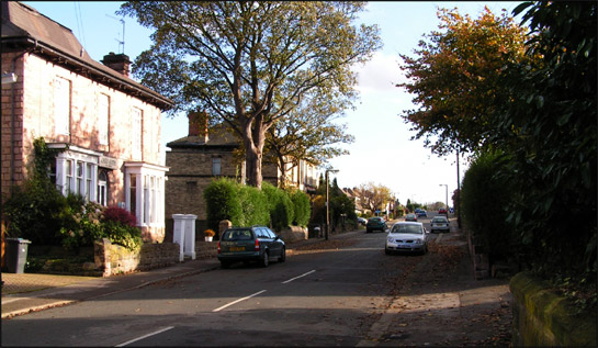
Figure 1: A typical street-scape in the ‘Clifton Villa Suburb’ character area
© 2005 SYAS
The character areas that make up this zone developed away from the town centre and industrial developments to its west and north - areas which were becoming increasingly densely developed, especially in Masbrough (Munford 2000, 113). In common with many of the industrial towns in northern England, poor sanitary provision in the urbanised centre of the town contributed to the spread of infectious disease through the poorest areas, for example during the cholera epidemic of 1832 (ibid), making housing outside these areas more desirable.
The principal period of development of this zone was between 1850 and 1891, although there is some overlap between earlier and later periods. The plan form of these character areas is characterised both by ribbon development, particularly along Doncaster Road and Moorgate Road, in addition to some more planned developments, particularly to the east and south - where plot boundaries and road patterns are based on grid patterns indicating piecemeal development of blocks of land.
As well as residential, this character zone includes institutional and ornamental character units, related in their establishment and preservation to the development of the villa housing. The most obvious of these units is Clifton Park, which acts as the central focal place of the ‘Clifton Villa Suburb’ area, whilst the ‘Moorgate Villa Suburb’ area includes Rotherham General Hospital, Thomas Rotherham College, the Swinden Technology Centre, Boston Park and Moorgate Cemetery, all of which have either 19th century origins or incorporate parts of 19th century villas.
Relationships with Adjacent Character Zones
The location of this zone appears to have been influenced by the availability of land in the mid 19th century, to the east and south of the already densely urbanised town centre away from the industrialised valley of the river Don. In the 20th century the remaining undeveloped land around the zone provided an attractive site for large scale municipal and private developments of a higher density, as suburban living became accessible to those with more modest incomes through rising provision of mortgages and council housing. This zone is, therefore, adjacent to both the historic core zone and the later municipal suburbs zone.
The development of villas was underway by the time of the 1850s OS mapping, with a possible ‘Land Society’ type development at Moorgate Grove already in evidence. These societies provided an important impetus to the development of 19th century suburbs. Once established, a society bought up whole estates and divided them into individual plots, members of the society paying a monthly contribution to costs and charges for making roads. The society would be wound up once costs for the land had been met. These types of land society were popular because they enabled larger numbers of people to vote as voting rights were linked to property ownership (Harman and Minnis 2004, 282). Characterisation work in Sheffield and Barnsley has shown that often suburbs established initially by land societies were later built on by much higher density grid iron terraced housing. This process may well reflect the fact that the primary motivation behind the subdivision of these areas of land was the acquisition of land by a wider sector of society, in a deliberate attempt to widen the population eligible to vote, rather than commercial development of housing. ‘Grid iron terraced housing’ developed during the late 19th and early 20th century alongside the ‘Clifton Villa Suburb’ character area. This denser development represented the expansion of an area of similar housing in the St Anne’s area (now cleared) and an intensification of the adjoining villa development.
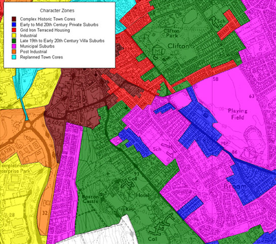
Figure 2: The villa suburb zone (green) grew close to the historic core of the town (as developed by 1850) but away from the industrial area to its west and north. Later suburban development has since enveloped these character areas.
OS 1:25,000 map base (not to scale) © Crown copyright. All rights reserved. Sheffield City Council 100018816. 2007
Inherited Character
The land on which these character areas were developed was mapped for its owner the Earl of Effingham in 1764, shortly after the Rotherham Enclosure Award of the same year (Kelk 1764; English 1984). Comparison of this map with modern OS mapping shows that the pattern of the enclosed countryside exerted a strong influence on later urban development. Preservation of earlier enclosure boundaries within these suburban developments is indicative of piecemeal phases of building within former enclosures.
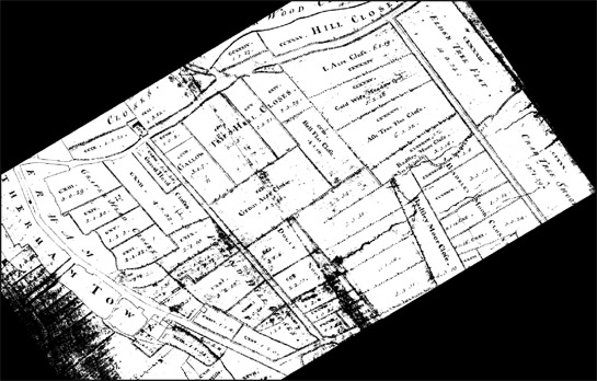
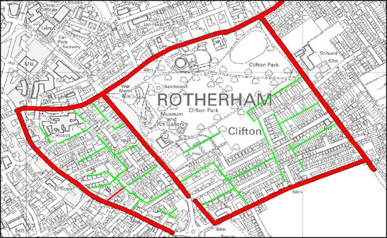
Figure 3: Comparison of this rectified extract of Kelk’s 1764 map of Rotherham (top) with the modern OS plan of the same area (bottom) shows how the earlier plan form influenced the pattern of the later suburb of Clifton (red shows pre-existing roads and green shows retained boundaries).
1:10,000 map base (not to scale) © © Crown copyright. All rights reserved. Sheffield City Council 100018816. 2007
The earliest building known within these character areas is Moorgate Hall, a listed building of five bays and two storeys, plus a pedimented third storey in the centre (EH 2005). It stands at the southern extremity of Rotherham, with the common grazing of Rotherham moor to the south until the mid 18th century. The present frontage was designed “by John Platt and was added in 1768 to an early C17 house of which much survives, notably the staircase” (Pevsner 1967, 421). John Platt II was commissioned in 1764, to provide “stables & offices for Mr Tooker” at Moorgate Hall (Elliott 1998, 127). Munford (2000, 69-70) claims a house stood on this site in the late 16th century, belonging to William West, seneschal & chief steward for the Earl of Shrewsbury's South Yorkshire manors and legal advisor to the feoffees; his son sold the house to Charles Tooker in 1627. Moorgate Hall remained a family home until 1986 when it was converted to offices. The Tookers of Moorgate Hall had steel furnaces (probably cementation furnaces) nearby in the 17th century, as well as a smithy (Munford 2000, 54-55).
Moorgate Hall serves as an exemplar of how those involved in Rotherham’s industries were able, by the late 18th century, to display their status by commissioning the best architects to develop houses with a certain level of pretension. By the late 18th century, the richest of Rotherham’s industrialists were unquestionably the Walker family. The first large house built by the family was at Masbrough in 1768-9, close to the family steel furnaces, but by the 1780s the second generation of the family chose the area to the east of the historic town for their mansions of Clifton House [1783-4] and Eastwood House [1786], both of which were designed by the eminent architect John Carr (Munford 2003, 38-39). Clifton House survives, within Clifton villa suburb, and was purchased by the council in 1891 at the time of the adoption of its park for municipal use. Eastwood House was demolished for the construction of villa housing between 1903 and 1923 (according to OS maps) – the site has since been reused as a teacher training college.
Later Characteristics
Because much of the villa suburbs that were laid out in the late 19th century were not fully built up, a range of housing styles developed within this zone, as available plots were gradually filled. These have, however, largely kept to a spacious design with mostly detached and semi-detached houses. This indicates a continuation of the middle class status of these suburbs.
Character Areas within this Zone
Map links will open in a new window.
Bibliography
- Doe, V.
- 1976 Some Developments in Middle Class Housing in Sheffield. In: S. Pollard and C. Holmes (eds.), Essays in the Economic and Social History of South Yorkshire. Barnsley: South Yorkshire County Council.
- English, B.
- 1985 Yorkshire Enclosure Awards. Hull: University of Hull Department of Continuing Education.
- English Heritage
- 2005 Listed Building System Data [unpublished MIDAS dataset export in xml format]. Swindon: English Heritage National Monuments Record. Available from: National Monuments Record Centre, Kemble Drive, Swindon.
- Elliot, B.
- 1998 ‘Architects of No Slender Merit’: Platt of Rotherham, 1700-1810. In: M. Jones (ed.), Aspects of Rotherham 3. Barnsley: Wharncliffe Publishing.
- Harman, G. and Minnis, J .
- 2004 Sheffield: Pevsner Architectural Guide. Yale and London: Yale University Press.
- Kelk, G.
- 1764 A Map of the Manor of Rotherham.
- Pevsner, N.
- 1969 Yorkshire: The West Riding [2nd edition with E Ratcliffe]. London: Penguin.
- Munford, A.
- 2000 A History of Rotherham. Stroud: Sutton Publishing Ltd.
- Munford, A.
- 2003 Iron and Steel Town: An Industrial History of Rotherham. Stroud: Sutton Publishing Ltd.