Late 20th Century Private Suburbs
Summary of Dominant Character
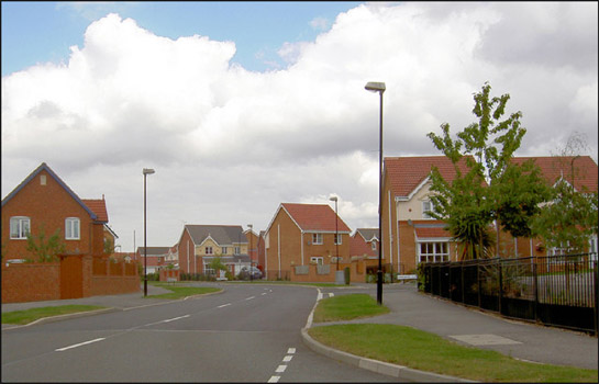
Figure 1: Modern private housing in Brampton, built on a site formerly occupied by tipping from Cortonwood Colliery.
© Steve Fareham. Used under ‘creative commons’ license [http://creativecommons.org/licenses/by-sa/2.0/]
This zone represents private suburban areas built since 1960, which tend to consist of relatively low-density estates of housing. Large estates often consist of just one housing type, although smaller estates sometimes contain a mix of bungalows, detached and semi-detached houses, as well as low rise flats. The earliest private housing developments in this zone often continue the layout principles seen within earlier municipal housing schemes, which had strong ‘garden suburb’ influences (see ‘Planned Industrial Settlements’ zone and ‘Municipal Suburbs’ zone). Housing density across the zone tends to be medium to low, with at least a rear garden common to most houses.
From the 1970s onwards, the layout plans of private housing estates are more commonly of cul-de-sac form, in contrast to contemporary municipal developments which tend to be based on variations of the ‘Radburn’ system of town planning. A further divergence between this zone and the municipal zone can be seen in the division of space around each property. Garden areas in this zone are consistently demarcated into individual private plots, whilst in municipal character areas private open space is less often provided in favour of unenclosed communal areas.
Cul-de-sacs are designed to minimise through traffic past the front of houses, whilst ensuring that each property has some form of vehicular access. As a result, properties do not generally front on to main roads, but are instead clustered around short branching off-shoots, increasing the privacy of each dwelling. An advantage of this plan is its adaptability to irregularly shaped plots of land, making it especially useful for infilling vacant plots within established areas of settlement.
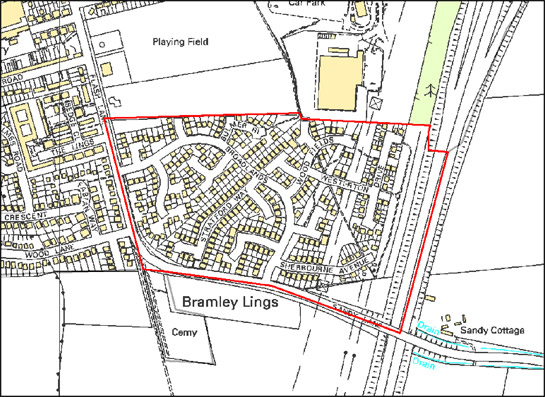
Figure 2: This 18 hectare cul-de-sac development in Bramley shows how the pattern reduces through traffic past most houses, the majority of which are situated on the roads that branch off the main arterial road of Broadlands.
© Crown copyright. All rights reserved. Sheffield City Council 100018816. 2007
The vast majority of the land in this zone has been characterised as having a residential character. The next most extensive land use is by institutional complexes, mostly government funded schools and their playing fields. Schools built during this period were generally constructed using building systems such as those developed by the public sector CLASP [Consortium of Local Authorities Special Project] group. Buildings constructed using the CLASP system (in common with private sector systems such as Vic Hallam’s ‘Derwent system’) feature significant amounts of prefabricated materials, and are generally formed of prefabricated steel frames infilled with asbestos, wood or concrete panels under flat roofs. The system was regarded as being particularly suitable for construction on sites liable to mining subsidence (CLASP n.d.). There are also a rising number of private and NHS old people’s homes within the zone.
Few settlements within Rotherham have not been altered by late 20th century suburbanisation, which has significantly expanded the amount of housing in the district. In the small rural settlements of the district, this suburbanisation process has sometimes doubled the size of the settlement. These are often considered to be desirable locations for people looking for a less urban lifestyle, leading to the creation of new estates at the edge of existing villages. Close to the M1 and M18 motorways, areas of late 20th century housing have developed as commuter belts.
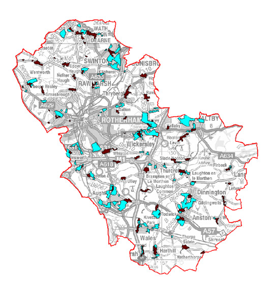
Figure 3: Late 20th Century Private Suburbs (blue) and Nucleated Historic Settlements (brown), which provide attractive locations for better off commuters.
Base mapping © Crown copyright. All rights reserved. Sheffield City Council 100018816. 2007
Relationships with Adjacent Zones
This zone is often directly adjacent to earlier suburbanisation or surrounds the historic core of rural villages, reflecting a continuing trend towards the expansion of the suburban landscape. This expansion has been driven not just by the continued population growth of the borough, but also by a general increase in prosperity, resulting in the growth of property ownership and the consequent movement of population from the urban centres to lower density urban fringe locations.
Small areas of late 20th century infilling will be found within other zones where they are too small to have registered as character areas in their own right.
Inherited Character
The majority of the suburban development within this zone has taken place on land that was used for agriculture prior to the late 20th century. This is a typical feature of this period of suburban expansion; small villages are expanded and suburbs grow around the edges of towns, sometimes linking former villages to a larger conurbation. There is often little former agricultural character visible within these modern estates; most of the units recorded by the characterisation project have only fragmentary or invisible legibility of the past landscape. This is due to the large scale on which some of these estates were developed, over writing the previous field boundary patterns with their new curving roads. Where aspects of the former field pattern do survive, these tend to either be where an estate has been built in phases, with the field boundary surviving as a tidemark between these phases, or where housing on the edge of an estate runs up to the edge or a former field. In some developments built since the mid 1990s it is possible that the introduction of the Hedgerow Regulations in 1997 (HMSO) may have encouraged hedgerow retention. These regulations require the notification of the Local Planning Authority before a hedgerow is removed, in addition to conferring powers on the same authority to serve a “Hedgerow Retention Notice” where hedgerows can be defined as important in historical, archaeological, wildlife or landscape terms.
Later Characteristics
The main period of historic character in this zone stretches from the 1960s to the time of the characterisation survey and, as a result, the dominant characteristics of this zone are, at the time of this study, continuing to form.
Character Areas within this Zone
Map links will open in a new window.
- Aston, Aughton and Swallow Nest Late Suburbs (Map)
- Bramley Late Suburbs (Map)
- Brampton and Melton Late Suburbs (Map)
- Brinsworth Treeton and Catcliffe Late Suburbs (Map)
- Brookhouse, Laughton Common and Throapham Suburbs (Map)
- Dalton Late Suburbs (Map)
- Eastwood Late Suburbs (Map)
- Firbeck Late Suburban (Map)
- Harthill and Woodall Late Suburban (Map)
- Kimberworth Late Suburbs (Map)
- Kiverton Park Late Suburbs (Map)
- Lings Common Late Suburbs, Bramley (Map)
- Maltby Late Suburbs (Map)
- Moorgate Late Suburbs (Map)
- North and South Anston Late Suburbs (Map)
- Ravenfield Common Late Suburbs (Map)
- Rawmarsh and Upper Haugh Late Suburbs (Map)
- Swinton and Kilnhurst Late Suburbs (Map)
- Thorpe Hesley Late Suburbs (Map)
- Thurcroft Late Suburbs (Map)
- Todwick Late Suburban (Map)
- Wath Late Suburbs (Map)
- Wickersley Late Suburban (Map)
Bibliography
- CLASP
- n.d. CLASP Consortium [online]. Available from:
http://www.clasp.gov.uk/NetBuildPro/process/6/History.html [accessed 14/03/08]. - HMSO
- 1997 The Hedgerows Regulation (Statutory Instrument 1997 No.1160).