Complex Historic Town Core
Summary of Dominant Character
This character area highlights the historic core of Rotherham, the area to the immediate east of the rivers Don and Rother that had developed as an urban settlement by the time of the first 6 inch to the mile Ordnance Survey map of 1851. The form of this area is made up of a tight cluster of streets, of probable medieval origin, around All Saints church comprising: High Street, College Street, Church Street, Bridgegate, Upper Millgate and Lower Millgate. The plan form of the property boundaries related to these streets has evolved from a typically medieval pattern of narrow plots or ‘burgages’ set at right angles to these streets and either retained or amalgamated through subsequent years.
Whilst the central feature of the plan is clearly All Saints church, an equally important feature in the plan has been the historic market area, which lies to the west of the church yard - an area bounded by Church Street, Domine Lane and Market Street. Connecting this central area to other settlements are Millgate, Westgate and Wellgate, to the south, and, to the east, Doncaster Gate, all of which may well be of medieval origin. Communications to the north, west of the river Don, have been facilitated by a bridge to the north end of Bridge Street, since the medieval period, (discussed in more detail below).
As with the other main historic town cores in South Yorkshire (principally Barnsley, Doncaster and Sheffield), the present townscape is a complex mixture of old and new buildings, with elements of earlier plan form retained through the replacement of buildings within historic property boundaries. This zone description will discuss the complexities of this pattern in the section ‘plan form analysis’ (below).
Relationship with Adjacent Character Zones
The character zones surrounding Rotherham’s historic core are intimately related to the processes that have operated to enlarge the settlement since its rapid evolution from market centre to industrial conurbation, from the 18th century onwards. Industrial and post-industrial landscapes dominate the area to the north and west of the River Don, where the smaller subsidiary settlement of Masborough was already becoming engulfed by the mid 19th century; developments in the iron and steel, glass and brass founding industries played an important part in this over the last 100 years. The best preserved examples of this industrial development can be found due west of Rotherham’s historic core – an area that includes the listed buildings of the Guest and Chrimes brass foundry.
To the north of this area of surviving industrial character, and encircling much of the north of the historic core, is a large area inside the Centenary Way urban dual carriageway that is now characteristic of the ‘Late 20th Century Replanned Centres’ character zone. This ‘Replanned Rotherham’ character area is dominated by late 20th century developments of commercial and municipal property, generally constructed by non traditional methods. This modern character area has developed on land cleared in parts from areas of former industrial and former high density terraced housing.
To the east of the historic core lies an area of surviving grid iron terraced housing of late 19th century date. This housing was developed to a lower density than that which has been subsequently cleared, and is mixed with large detached properties. The south eastern and southern fringes of the historic core also border on areas with residential characteristics. The ‘Moorgate Villa Suburb’ to the south of the historic core developed along Moorgate Road from the mid 19th century onwards.
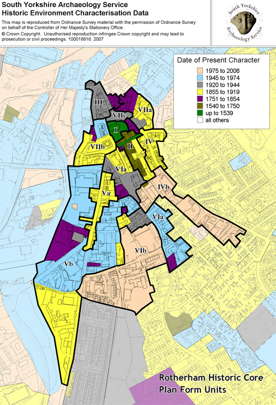
Figure 1: Plan form units within the historic core of Rotherham.
Plan form Analysis of Rotherham’s Historic Core
The layout of the historic core of Rotherham survives well, with many earlier road patterns remaining. Through a combination of historic map analysis, consideration of archaeological excavations and comparison with other medieval settlements, the development of the town can be described, with degrees of historic legibility and later development considered in each plan unit.
Plan Unit I – All Saints Church
The present church of All Saints is now largely characterised by work of the Perpendicular architectural period (c.1335-50 to c.1530), although evidence exists for earlier building phases - with Saxon and Norman architectural fragments reused in foundation courses (Ryder 1982a, 96).
Plan Unit II – High Street Burgage Plots.
This plan unit consists of thin and narrow plots set perpendicular to the High Street. The plot series are reasonably well preserved, with little amalgamation of plots. The buildings standing on these plots include the former Three Cranes public house. This timber framed building is a composite structure, the frontage of which dates to the late 16th to 17th centuries, whilst an earlier wing consists of a medieval open hall block that retains evidence for a high status ‘coved’ area at one end, in addition to the remains of a vaulted undercroft beneath (YAJ 1980, 8; SMR ref: 1131). This building represents a potentially unique survival for South Yorkshire of in situ medieval domestic architecture on a burgage plot.
The plots to the south of High Street are significantly longer than others within the town, perhaps indicating a primacy within the urban hierarchy. Further evidence of their medieval date was demonstrated by archaeological excavations to the north of High Street (McCluskey 2005), which exposed a ditch perpendicular to the street. This was interpreted as a medieval property boundary as it contained 12th century pottery; it was sealed by a layer containing 13th-14th century pottery. Other plots contain listed buildings of 18th and 19th century date. To the east of the southern plot series some plots have been amalgamated to form sites suitable for 20th century retail properties, whilst to the west the series was interrupted in the late 19th century by an extension of Moorgate Street (see unit VIa).
Plan Unit III – Corporation Street to Bridgegate
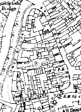
Figure 2: (above) 1893 OS map of Bridgegate
© and database right Crown Copyright and Landmark Information Group Ltd (All rights reserved 2008) Licence numbers 000394 and TP0024
This unit’s importance in the medieval period would have lain in its connection of the fording point (later a bridging point) across the Don and the market and ecclesiastical centre to the south. The area includes the Chantry Bridge, which, whilst largely a 20th century replacement of the medieval bridge, retains part of the medieval structure - on which stands a rare example of a medieval bridge chapel.
Historic maps show the primary plot series of this plan unit, i.e. where the plots are longest in length, to be those facing on to Bridgegate. On historic maps, for instance the 1891 25 inch to the mile OS, a number of the boundaries of this plot series can be traced as continuous lines all the way through to the (now) lost Lower Millgate Street. This could suggest that Lower Millgate originally functioned as a ‘back lane’, providing rear access to the primary burgages. Lower Millgate Street originally ran alongside the eastern bank of a channel of the River Don. In the early 20th century this eastern channel (which may have been deliberately kept clear for the purposes of returning the water from the town mill to the main river) appears to have first silted up and then been made into new developable land at the time of the construction of Corporation Street in 1913 (Munford 2000, 126). The new street truncated the western edge of the original plots of this unit, resulting in the development of new buildings along this side.
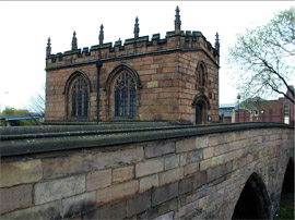
Figure 3: (above) Medieval bridge chapel
Photo © SYAS
Some plots may fossilise earlier boundaries but otherwise little pre-20th century fabric survives. Medieval legibility is strengthened by the survival of the chantry chapel on the bridge over the River Don.
Plan Unit IV – Wellgate / Doncaster Gate early 20th century development
A series of regular narrow plots along both Well Gate and Doncaster Gate are shown on Rotheram’s 1774 plan of the town. The present buildings are likely to contain a majority of elements from the early 20th century although piecemeal redevelopment, with the survival of earlier forms, is possible. The layout of property boundaries here appears little changed since the 1850s, with good continuity of back to the medieval period likely.
Plan Unit IVb – Wellgate suburban area
Suburban development along Wellgate was already in evidence by the OS survey of 1851 and initially included some larger properties, such as the 18th century Wellgate Hall, itself likely to have been built on the site of a medieval manor (SYAS 2008, SMR ref 795). This property was industrialised by the mid 19th century, with a small chemical works erected in its grounds for the processing of dyes and pigments. By then much of the land within this plan unit had been developed as high density terraced and courtyard housing. This housing was in turn cleared in the later 20th century. This plan unit is now characterised by large late 20th century buildings surrounded by car parking and set in plots that are largely of modern origin. It includes office buildings, industrial and retail premises.
Plan Unit Va – Westgate
This plan unit is within the area shown as developed on 18th century maps, with a pattern of traditional narrow plots between the junctions of High Street and Sheffield Road.
This area of Rotherham saw much light to medium scale industry on land behind the street frontages in the 19th century. However, the decline of this sector during the 20th century led to economic deprivation of the area. Current land use falls firmly within the 'suburban commercial core' Broad Type, with a high proportion of early 20th century public houses, with characteristic frontages, and a few terraced retail shops and a telephone exchange building that have been identified by Jessop and May (2004) as being of medium to high historic potential.
Although the plan unit's present character dates mostly to the turn of the 19th and 20th centuries, current properties maintain some historic boundaries, despite their truncation by the developments of plan unit Vb.
Plan Unit Vb – Westgate Industrial Area
This plan unit was initially developed as traditional narrow plots as far south as the present junction of Westgate and Sheffield Road (described in unit Va above), with further ribbon development following similar patterns in the early 19th century, largely infilling and subdividing strip enclosures shown on the 1764 enclosure plan. The burgage plots shown on 18th century mapping had evolved into a mixed light industrial area by time of the 1851 OS survey, with many small courtyards of high density housing behind the frontages to the north of the unit. Conversely, the residential character of the southern half of the unit was dominated by larger middle class housing and orchards.
By the early 20th century bylaw terraced housing was encroaching to the south, whilst the courtyard dwellings had begun to be cleared in favour of light industrial units. By the mid 19th century, high density residential development lay alongside at least three foundries and a railway station to the west of Westgate. These developments had all been cleared and replaced by the mid 20th century. The eastern side of Westgate remained largely residential until the decline of this area in the later 20th century. By the 1980s and 1990s most of the housing in this area had been cleared in favour of prefabricated units, mostly concerned with motor trade businesses.
This area is now characterised by large open areas and buildings of typically mid 20th century date, although there are some 19th century industrial and institutional survivals. Jessop and May (2004) have identified a number of surviving features related to the 19th century fabric of the area, with historic potential.
VIa – Rotherham Town Hall, The Crofts and Upper Moorgate.
This plan unit is dominated by a large rectangular open area, shown on the 1764 enclosure map, that was the site of the town’s cattle market until this was moved to a new site in Corporation Street. This occurred at the time of the construction of the police station and court house (now used as the Town Hall). This open space lies to the rear of a series of burgage plots on Wellgate and High Street, and to the north of an area of surveyed enclosure (shown on the 1764 plan). Its western boundary is formed by Moorgate Street, re-routed from its historic course (now Ship Hill) in the late 19th century, through the High Street plots (Unit II).
The oldest building within this area is the Methodist chapel to its west. The properties in the area now front on to Ship Hill and Moorgate, but formerly occupied High Street burgage plots.
VIb – Southgrove school site, Moorgate Nursing Home and The Maltings Sheltered Housing Scheme.
This plan unit is now occupied by a mixture of buildings dating to the late 20th and early 21st century. These include the site of the former South Grove School (under development as new build offices at the time of a site visit in 2005), which was built in the early 20th century on the site of a large villa, ‘South Grove’; a nursing home, built on the site of the former Rotherham Union Workhouse (built c.1840), after its demolition in the 1980s; and a sheltered housing scheme also dating to the 1980s, on the site of a late 18th century malthouse that was cleared in the 1970s. Very little legibility of earlier developments remains.
VIIa – Effingham Street
This area represents an area of the medieval settlement core between the medieval College Street and Howard Street. Howard Street was laid down in the 1850s (Munford 2000, 117) and follows the approximate line of the historic common boundary behind the Bridgegate and College Street burgage plots, before joining with the former Pigeon Lane (shown on Rotheram’s 1774 map), running between the Doncaster Gate burgages.
This area was notable in the medieval town for including the site of the College of Jesus (SYAS 2008, SMR ref:189), erected by Thomas Rotherham in 1483 as a college for priests of the collegiate church of All Saints. This college comprised a quadrangle of buildings around a college yard, which survived in large part until the mid 19th century although in reduced circumstances, after the dissolution of the chantries in 1547.
After dissolution the college estate, which included orchards, gardens and grazing lands, was acquired by the Earl of Shrewsbury (Guest 1880). The buildings seem to have been put rapidly to secular use - in 1590 a local rector was to bemoan the use of the buildings as a malthouse (Munford 2000, 43). On the 1774 map of the town the surviving building is marked on the town map as the College Inn. Its remains are currently encased within the buildings of the Woolworths store - other parts of the college may lie under Effingham Street to the west, which was driven through the college yard in the mid 19th Century.
This area was subject to radical change following a private Act of Parliament gained by the Earl of Effingham in 1850 (Munford 2000, 117) that enabled him to grant long leases on his land. This gave the Earl the opportunity to lay out a new grid pattern of streets to the north and east of the town core around the newly laid out Effingham Street. The land within this grid was then divided into building plots that could be leased to speculative developers for further improvement. During the second half of the 19th century the area to the west of Effingham Street was developed as commercial buildings, whilst the environs of the college to the east of the new street seem to have developed as institutional buildings, including a court house, police station and National School. At present the western plots consist of mid-late 19th century commercial buildings, but the eastern plots have been rebuilt and date to the mid-late 20th century.
VII b – The ‘Market Place’
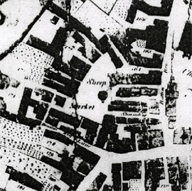
Figure 4: The market area in 1774 (above) shown on Rotherham's plan of the town.
This plan unit, largely under redevelopment during the life of this project as part of the Rotherham Renaissance programme, represents the historic site of Rotherham’s market place. Historic mapping suggests that the medieval market place lay to the south east of the church yard, an arrangement that has also been suggested at Doncaster. The 1774 map of the town shows an open area labelled Sheep Market, with burgage plots aligned along its western side a dense concentration of semi-regular streets, including one labelled Shambles (traditionally a placename associated with the stalls of butchers). The four narrow passages running back (from what is now Church Street) towards the market place probably relate to the provision of street frontages for shops. It is possible that these streets emerged as ‘market accretions’, as stalls were gradually made into more permanent structures - again a process already suggested in a number of medieval market places, most locally at Doncaster (Slater 1989, 51).
This eastern side of the market place was swept away in the early 19th century as a result of an Act of Parliament, sought in 1801 “for enlarging and improving the Market Place … of Rotherham” (Munford 2000, 109). A new Shambles, shown on 19th century OS mapping, was the key result of this Act, providing accommodation for twenty eight shops on its exterior and 20 butchers and fishmongers stalls on its interior (ibid).
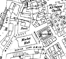
Figure 5: The Market Place area by 1891, shown on the OS 25" map.
Historic OS map © and database right Crown Copyright and Landmark Information Group Ltd (All rights reserved 2008) Licence numbers 000394 and TP0024
The 19th century shambles were replaced in the early 20th century with the present Imperial Buildings. The rest of the open market place, including its western burgages, remained and a corn exchange was added in 1841. However, in 1879 the properties to the west were comprehensively cleared by the Local Board and replaced with a new Market Hall, first built in iron and glass and then, by 1889, in brick (see plan above). This late 19th century development (demolished in the 1970s) established the street pattern that still survives today.
VIIc – All Saint’s Square
All Saints Square was created in 1933 by the removal of a block of properties between College Street and All Saints church (Munford 2000, 135). Re-landscaped in the 1990s, this area is currently a public open space featuring a large TV screen. Earlier buildings on the plot included a dispensary, Grammar School and New Assembly Rooms built in the 1820s (ibid, 117). This area was shown built up on the 1774 map of the town and is likely to have been densely occupied in the medieval period.
Character Area within this zone
Map links will open in a new window.
- Rotherham Historic Core (Map)
Bibliography
- English, B.
- 1985 Yorkshire Enclosure Awards. Hull: University of Hull.
- Guest, J.
- 1880 On Rotherham and its Ecclesiastical and College Buildings. Journal of the British Archaeological Association, December, 1880, 377-397.
- Hey, D.
- 1979 The Making of South Yorkshire. Ashbourne: Moorland Publishing.
- Jessop, O. and May, R.
- 2004 Archaeological Desk-Based Assessment and Buildings Appraisal for Westgate, Rotherham, South Yorkshire [unpublished]. ARCUS for Rotherham MBC.
- Kelk, J.
- 1764 A Map of the Manor of Rotherham in the West Riding of Yorkshire
- McCluskey, B
- 2005 Speeds Building, 14-15 Vicarage Lane / 18 High Street, Rotherham, South Yorkshire [unpublished document] client report for Pheonix Enterprises by ASWYAS, Morley, Leeds.
- Munford, A
- 2000 A History of Rotherham. Stroud: Sutton Publishing Ltd.
- Rotheram, B.
- 1774 A Plan of the Town of Rotherham in the County of York drawn for the Earl of Effingham.
- Ryder, P.F.
- 1982 Saxon Churches in South Yorkshire. Barnsley: South Yorkshire County Council.
- Slater, T.
- 1989 Doncaster’s Town Plan: An Analysis. In: P. Buckland, J. Magilton and C. Hayfield, The Archaeology of Doncaster 2. BAR British Series 202.
- SYAS
- 2008 South Yorkshire Sites and Monument Record [dynamic MS Access – GIS database] Sheffield: South Yorkshire Archaeology Service. Available by appointment with SYAS, Howden House, 1 Union Street, Sheffield, S1 2SH. Email: syorks.archservice@sheffield.gov.uk.
- YAJ
- 1980 Yorkshire Archaeological Journal 51