Rotherham Replanned Centre Zone
Summary of Dominant Character
This zone represents the post-World War II changes to the northern part of Rotherham town centre. Dramatic programmes of urban renewal took place nationwide during this period. Areas were generally cleared wholesale of earlier buildings and features, and street patterns were reconfigured. In Barnsley, Doncaster and Sheffield this process generally overlapped with parts of the medieval town cores. In Rotherham, however, the zone lies immediately to the north of the medieval centre – in an area of urban expansion by the Earl of Effingham in the 19th century, although some of the zone (to the west of the river Don) overlaps with the historic settlement of Masborough.
The principal land uses in this zone are commerce, transport infrastructure and institutional, each of which occupies around 30% of the land surface. Residential property, which in the 1940s characterised 55% of the area of this zone, is almost entirely absent. This reflects the influence of planning decisions made by local government, seeking to create a commercial and administrative centre for the town connected to the rest of the borough by efficient modern transport links.
The components of this zone are linked by a gyratory system of roads, designed as urban dual carriageways, which pedestrians were generally discouraged to cross at surface level. To facilitate crossing, a large number of pedestrian bridges and subways were built, especially at roundabouts. Character units characterised within the ‘Communications’ Broad Type, (Ring Road, Car Parks and Bus Stations / Interchanges) account for 26% of the land within this zone.
The architectural style of the zone is typical of similar areas of post-war urban renewal in South Yorkshire and beyond. The modernism of the zone’s planning is expressed in ‘new’ materials, often suited to prefabricated construction techniques, such as concrete, steel, glass and composites like plastics. Municipal buildings and road schemes built in this style from the 1950s to 1980s are of particularly uncompromising style. Examples include the brutalist Civic Building, Norfolk House and the Central Library and Arts Centre.
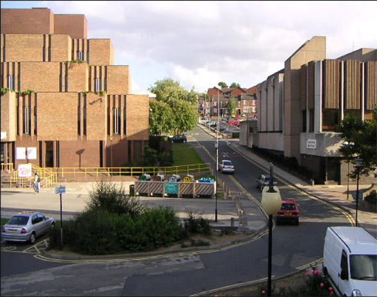
Figure 1: Norfolk House (left)’ and the Central Library and Arts Centre (right) are examples of the modernist architecture championed by many municipal authorities in the late 20th century.
Image © 2005 Christopher Thomas – used under a creative commons licence http://creativecommons.org/licenses/by-sa/2.0/
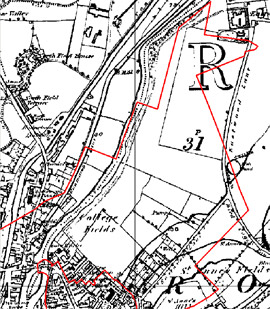
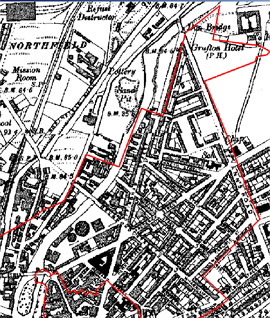
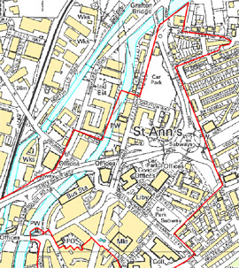
Figure 2: The evolution of the north eastern part of the replanned centre zone, shown on OS maps of 1854, 1905 and 2002.
Modern mapping © Crown copyright. All rights reserved. Sheffield City Council 100018816. 2007. Historic mapping © and database right Crown Copyright and Landmark Information Group Ltd (All rights reserved 2008) Licence numbers 000394 and TP0024
Inherited Character
The most dramatic change of character in this zone during the post-war period was the near complete clearance of residential character units between St Anne’s Road and Howard Street, to the north east of the historic core of the town.
This area was first subject to urban development following a private Act of Parliament gained by the Earl of Effingham in 1850 (Munford 2000, 117) that enabled him to grant long leases on his land. This gave the Earl the opportunity to lay out a new grid pattern of streets to the north and east of the town’s core, around the newly laid out Effingham Street. The land within this grid was then divided into building plots that could be leased to speculative developers for further improvement. The majority of this land was developed as terraced housing in the later 19th century. Whilst often of a high density, with undivided shared yards common (in a similar style to that seen across Sheffield), no actual ‘back to back’ property seems to have been constructed.
Historic map evidence points to the clearance of this housing around the 1960s, in advance of the construction of the present developments. Some aspects of the street pattern remain, including Effingham Street, although there are points at which it has been interrupted by changes to the road system, and the grid pattern so clear in the early twentieth century has been largely lost. The clearest legibility of the Earl of Effingham’s 19th century developments are a small triangle defined by Howard, Effingham and Fredrick Streets, where buildings include the former Mechanics Institute, Old Town Hall, School of Art and banks. These buildings have now all been converted at street level with modern shop fronts, with a modern shopping arcade created through the centre.
Industrial activity within this zone developed mostly to the west of the river Don, in Masborough. One of the most important early industrial complexes here lay to the west of Masborough Street, where significant investment in furnaces and works buildings was undertaken by the Walker family in the mid 18th century - close to the newly established South Yorkshire Navigation Canal (Munford 2003, 23). In the later 19th century the surrounding area was developed as back-to-back and terraced housing. The only part of this area to retain 19th century buildings now is at Chapel Walk where there are some surviving fragments of the Cupola Works of Samuel Walker and John Booth. These buildings now house a scrap metal business.
Later Characteristics
Redevelopment of the commercial, business and entertainment facilities within the urban centre of Rotherham is a continuing process. In the late 1990s and early 21st century, projects to revitalise the region’s economy were instigated. Major rebuilding projects in the centre of the town have been part of this process; these have included the replacement of some of the extensive commercial developments of the 60s and 70s, which are considered to be dated and inappropriate for modern shoppers. These ongoing changes now form a part of the regeneration programme known as ‘Rotherham Renaissance’ (Rotherham Renaissance 2008).
Character Areas within this Zone
Map links will open in a new window.
- Replanned Rotherham (Map)
Bibliography
- Munford, A.
- 2000 A History of Rotherham. Stroud: Sutton Publishing Ltd.
- Munford, A.
- 2003 Iron and Steel Town: An Industrial History of Rotherham. Stroud: Sutton Publishing Ltd.
- Rotherham Renaissance
- 2008 Rotherham Renaissance: a new beginning [online]. Available from: http://www.rotherhamrenaissance.co.uk [accessed 01/08/2008].