Strip Enclosure
Summary of Dominant Character
This zone is characterised by long thin curving fields, sometimes all running in the same direction and sometimes forming a patchwork pattern across the landscape. These patterns are interspersed with more irregular enclosures with some curving boundaries. Field boundaries in this zone are typically hedged and field sizes are much smaller than those typical today. More and older boundaries, with a greater number of mature trees within them, can be found in the character areas to the north and west of the main Rotherham conurbation, where the land is less suitable for modern arable cultivation and a greater proportion is currently managed as permanent pasture. There is little dispersed settlement in this zone.
Relationships with Adjacent Character Zones
Areas of ‘Strip Enclosure’ are almost exclusively found in association with ‘Nucleated Rural Settlements’. Where this is not the case it is possible that an earlier settlement has shrunk to such an extent that it cannot be recognised. This contrasts with areas of ‘Assarted Enclosure’ where the settlement pattern tends to be one of dispersed farmsteads. This has long been noticed in landscape studies as a classic example of the relationship between social and landscape patterning. Rackham (1986, 3-5) recognises the distinction between ‘Ancient’ and ‘Planned’ countryside and this is broadly comparable to the ‘dispersed’ and ‘nucleated’ settlement zones in Roberts and Wrathmell (2000).
Historically across the Rotherham district, the areas of strip enclosure and nucleated settlements made up a clearly planned landscape, but modern agricultural practices have resulted in significant boundary loss. Many former areas of strip enclosure have, therefore, been categorised as part of the ‘Agglomerated Enclosure’ zone.
Inherited Character
The nature of the previous landscape is the defining feature of this zone. The patterns of strip fields seen in this zone resulted from the piecemeal enclosure of former open fields. In the medieval period, large open areas of land were cultivated in long thin unhedged strips that were “individually owned but farmed in common” (Taylor 1975, 71). The land would be ploughed into ridges by oxen and often the practice of turning the plough team at the end of each strip would produce a characteristic reverse ‘s’ shape that could be fossilised by later enclosure (ibid, 78-80).
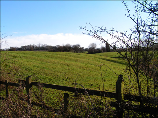
Figure 1: Ridge and Furrow earthworks to the east of the village of Carr in the ‘Carr Strip Enclosures’ character area. Preservation of ridge and furrow earthworks depends on the conversion and continued management of the land on which they survive as grasslands.
© SYAS 2006
Within open field systems, ownership of strips of land was scattered throughout the common fields. This meant that people could own a mixture of the good and bad soils. This pattern of land ownership made communal farming necessary, as strips within the same unhedged area could not be used for corn whilst others were turned to fallow and grazing. There were, therefore, typically three large fields of strips that could be farmed in rotation in the open field system (a pattern common across the English Midlands) (Hall 2001, 17).
Examples can be found of common arable practices continuing in the Rotherham district until well into the 19th century, including significant areas of West Field, Brampton (character unit HSY3112); West Field, Thorpe Hesley; and Cortworth Field, Wentworth, all enclosed in the early 1820s. These areas all lie within the ‘Surveyed Enclosure’ zone. Evidence from this zone and from former strip enclosures within the ‘Agglomerated Enclosure’ zone suggests that the enclosure of open fields by Parliamentary award was very much a ‘final settlement’ of a process of gradual enclosure ‘by agreement’ that had been underway for centuries. From the 15th century onwards, farmers were exchanging dispersed strips throughout open or town fields, to obtain contiguous blocks of land that could be enclosed (Rackham 1986, 170). Enclosure award maps from Rotherham district confirm this, with most showing significant areas of existing ‘ancient inclosures’ that conform to ‘strip enclosure’, in advance of the enclosure of remaining areas of common arable and common grazing lands.
Within this zone, the fossilisation of patterns of narrow strips by sinuous curving hedges is clearest at, ‘Kingsforth Field Strips, Wickersley’; ‘Wentworth Clay Field and Barrow Field’; and at ‘Wath Golf Course, Abdy’.
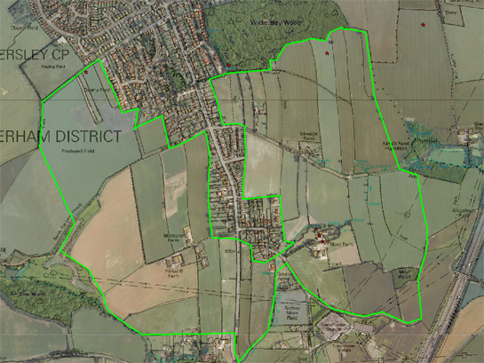
Figure 2: The ‘Kingsforth Field Strips, Wickersley’ character area shows a clear semi-regular pattern of narrow curving fields indicative of the piecemeal enclosure of former open fields. The eastern part of this area has been subject to less 20th century boundary loss.
Cities Revealed aerial photography © the GeoInformation Group, 1999; OS 1:10000 © Crown copyright. All rights reserved. Sheffield City Council 100018816. 2007
Later Characteristics
There has been some boundary loss within the ‘Strip Enclosure’ zone but this has occurred on a less significant scale than on land within the ‘Agglomerated Enclosure’ zone. The biggest influence on this process appears to be the dominant 20th century land use, with land suitable for intensive arable cultivation more likely to be subject to boundary loss than land suitable for pasture.
Across the zone there has been modern expansion and alteration of surviving farms. This has often been in the form of the introduction of modern corrugated shed-type barns, more suited to the mechanised agricultural practices of the later 20th century than traditional barns.
Some late 20th century land uses may have acted to preserve the historic strip pattern characteristic of this zone. North of the small medieval hamlet of Abdy a significant group of post-medieval strips survives within the landscaping of ‘Wath Golf Course’. The ornamental reuse of this landscape has protected these strips from the agglomeration that is so characteristic of surrounding fields.
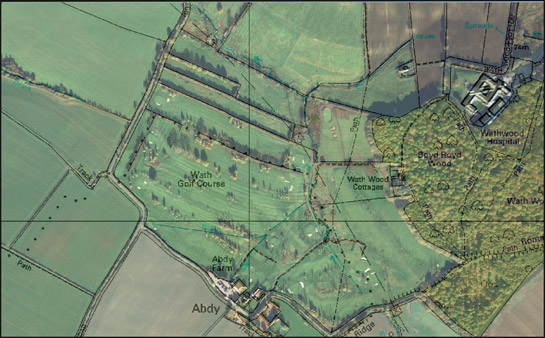
Figure 3: At Wath Golf Course there is partial legibility of former piecemeal strip enclosures, through the reuse of mature trees taken from earlier hedgerow boundaries in the landscaping of the course.
Cities Revealed aerial photography © the GeoInformation Group, 1999; OS 1:10000 data © Crown copyright. All rights reserved. Sheffield City Council 100018816. 2007
Character Areas within this Zone
Map links will open in a new window.
- Brampton en le Morthen Strip Enclosure (Map)
- Carr Strip Enclosures (Map)
- Gibbing Greave Strips, Herringthorpe (Map)
- Gildingwells Enclosed Strips (Map)
- Golden Smithies, Enclosed Strips, Wath (Map)
- Harthill and Woodall Strips (Map)
- Hooton Roberts Strip Enclosures (Map)
- Kingsforth Field Strips, Wickersley (Map)
- Laughton en le Morthern Strip Enclosures (Map)
- Little Common Lane Enclosures, Kimberworth (Map)
- Land North of Sandbeck Lane, Maltby (Map)
- Mexborough South (Map)
- Wath Golf Course, Abdy (Map)
- Wentworth Clay Field and Barrow Field (Map)
Bibliography
- English Heritage
- 2005 Listed Building System Data [unpublished MIDAS dataset export in xml format]. Swindon: English Heritage National Monuments Record. Available from: National Monuments Record Centre, Kemble Drive, Swindon.
- Hey, D.
- 2002 A History of Penistone and District. Barnsley: Wharncliffe Books.
- Hall, D.
- 2001 Turning the Plough. Midland Open Fields: Landscape Character and Proposals for Management. Northampton: Northamptonshire County Council and English Heritage.
- Rackham, O.
- 1986 The History of the Countryside. London: J.M. Dent.
- Roberts, S. and Wrathmell, S.
- 2000 An Atlas of Rural Settlement. London: English Heritage.
- Taylor, C.
- 1975 Fields in the English Landscape. London: J.M Dent.