Agglomerated Enclosure
Summary of Dominant Character
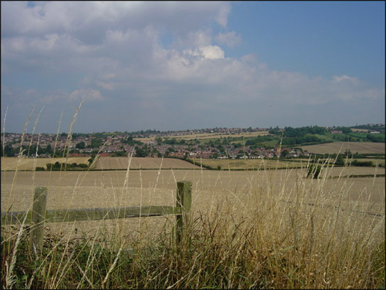
Figure 1: This view across Whiston captures the large areas of arable land with few boundaries typical of this zone.
© John Charlton 2005, licensed for reuse according to a Creative Commons licence http://creativecommons.org/licenses/by-sa/2.0/
The ‘Agglomerated Enclosure’ zone dominates much of the open countryside of the borough across both the Magnesian Limestone and Coal Measures Sandstone geological areas. Within the predominantly enclosed agricultural landscape of this zone1, intensification in arable farming is immediately apparent in the enormous areas of land with few hedgerow boundaries that are seen when compared to 19th century mapping. As a result of this boundary loss, 78% of the character units defined as ‘Enclosed Land’ within this zone have been recorded within the project database as 'Agglomerated Fields'. Despite this, closer examination of the landscape of this zone reveals a deeper history - of an agricultural landscape planned in the medieval period, or earlier, and based on the medieval common arable system. Evidence for this earlier history includes field boundaries and better surviving road patterns that exhibit the characteristic sinuous curves of former open field patterns. Such surviving elements are only a very small percentage of the similar boundaries depicted on 1850s OS mapping. In contrast, the zone contains the majority (70%) of the surviving ancient woodland in Rotherham. Pre-20th century farm buildings in this zone typically feature lime or sandstone walling and red clay tile roofing. However, from the mid twentieth century onwards many have been augmented by large prefabricated metal shed-type barns.
Relationships with Adjacent Character Zones
The landscapes of this zone alternate with landscapes of the ‘Surveyed Enclosure’ zone. Distinctions between the two zones can be subtle and difficult to identify on the ground, with both types having been subject to 20th century agricultural intensification.
Scattered throughout these two zones, and historically related to the common field heritage underlying both of these types of enclosure patterns, are a number of villages from the ‘Nucleated Rural Settlements’ zone. The agricultural productivity of the soils overlying the Coal Measures and limestone has historically facilitated the accumulation of large agricultural surpluses. From the 17th to 19th centuries this wealth was displayed through the establishment of large landscaped parklands. Elements of the ‘Private Parklands’ zone adjacent to this zone can be found at Sandbeck, Firbeck and Wentworth.
In the 20th century, the underlying limestone bedrock and coal seams were intensively exploited and significant landscapes of the ‘Extractive’ and ‘Post Industrial’ zone exist in close proximity to this zone – sometimes as islands within it.
Inherited Character
The principal historic features legible in this zone consist of elements relating to non-surveyed or ‘piecemeal’ patterns of land enclosure. The patterns visible on 19th century mapping throughout this zone suggest that most of the enclosed land here at that time had developed from large open fields surrounding nucleated villages, in a pattern typical of much of the English Midlands (see Hall 2001, 13-15). The characterisation project defines ‘Strip Enclosure’ character units as;
“Fields resulting from the enclosure of medieval open fields. Typically these fields are at least 5 times longer than their width with essentially parallel sides exhibiting reverse-s curve boundaries fossilising the shape of earlier cultivation strips within the common field” (SYAS 2005).
This type of enclosure pattern is generally thought to have resulted from the private enclosure of common arable units via the sub-division of large open fields from the late medieval period onwards (Taylor 1975, 78-80). Within this zone the agglomeration of fields in the 20th century has erased much evidence of this pattern – in some cases the present enclosures are comparable in scale to medieval open fields.
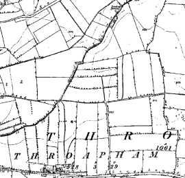
Figure 2: These extracts show how post-medieval strip enclosures depicted in 1854 (left) have been removed by 2003 (right), resulting in units of a similar scale to the earlier medieval land enclosure pattern.
Historic mapping © and database right Crown Copyright and Landmark Information Group Ltd (All rights reserved 2008) Licence numbers 000394 and TP0024; Modern mapping reduced from 1:10000 OS Mapping © Crown copyright. All rights reserved. Sheffield City Council 100018816. 2007
Many of the fundamental patterns and features underlying this landscape pre-date the period of piecemeal enclosure. Many lanes and some longer continuous boundaries, for example those that enclosed the earlier open fields or marked the edges of parishes, may well have been established in the medieval period.
This character zone includes 70% of the rural ancient woodlands in Rotherham2. Council owned ancient woodlands in Rotherham have been subject to a detailed programme of archaeological survey, as part of the ‘Fuelling the Revolution’ project, vastly increasing the records of known archaeological sites within them (Cumberpatch 2001; Lee and Richardson 2003; Lee 2005). However, within this zone the woodlands are typically in private ownership and as a result they have not been surveyed. It is probable that they contain many more earthworks than are currently recorded on the South Yorkshire SMR. Existing records for earthworks in woodlands within this zone already include: Iron Age and Romano-British enclosures; industrial remains, such as the mining spoil heaps from bell pit extraction - in the west of the borough; and medieval strip lynchets / ridge and furrow. Woodlands in this zone display a close relationship with historic parish boundaries; most of the character units identified as ‘Ancient Woodland’ in this zone intersect with a historic parish boundary (Jones 1995, 72; 2000, 54-55).
Later Characteristics
The loss of boundaries that has produced the open character of much of this zone appears to have been most significant in the second half of the 20th century. This process has continued into the present, as the economies of scale provided to farmers by larger land parcels continue to offer incentives to remove hedges. Acting to counter this trend are incentives offered by the ‘stewardship’ schemes sponsored by central government since the early 1990s. These schemes offer financial incentives to farmers who enter into environmental management agreements; these can include the maintenance or restoration of historically characteristic features such as boundaries and buildings and (under the Environmental Stewardship system in place since 2005) reduction in the impact on known buried archaeological sites (Rural Development Service 2005, 68-70).
A contemporary development has been the introduction of the Hedgerow Regulations of 1997 (HMSO). This requires the notification of the Local Planning Authority before the removal of a hedgerow, in addition to conferring powers on the same authority to serve a “Hedgerow Retention Notice” where hedgerows can be defined as important in historical, archaeological, wildlife or landscape terms.
Other late 20th – early 21st century influences on this historic character zone relate to adjacent zones. Most notable is the presence in this zone of parts of the M1 and M18 motorways. These routes are generally superimposed across landscape features of earlier origin. Their dominant constructional materials are concrete, steel and massive earthen embankments, which generally sever earlier previously coherent landscape units into newer ones.
Character Areas within this zone
Map links will open in a new window.
- Anston Agglomerated (Map)
- Bramley and Hellaby Agglomerated (Map)
- Greaseborough Agglomerated (Map)
- Harthill Field and Hunger Hill (Map)
- Hooton Levitt to Gildingwells Agglomerated (Map)
- Agglomerated Enclosures West of Laughton en le Morthen (Map)
- Newhall Grange (Map)
- Rainborough Agglomerated (Map)
- Ravenfield to Dalton Agglomerated (Map)
- Scholes Former Open Fields (Map)
- Agglomerated Enclosures West of Todwick (Map)
- Whiston to Treeton Agglomerated Enclosures (Map)
Bibliography
- Cumberpatch, C.
- 2001 An Archaeological desktop study of four areas of woodland in Rotherham [unpublished]. Sheffield: CG Cumberpatch BA PhD Archaeological Consultant.
- Hall, D.
- 2001 Turning the Plough. Midland Open Fields: landscape character and proposals for management. Northampton: Northamptonshire County Council and English Heritage.
- HMSO
- 1997 The Hedgerows Regulation (Statutory Instrument 1997 No.1160).
- Jones, M.
- 1995 Rotherham’s Woodland Heritage. Rotherham: Rotherwood Press.
- Jones, M.
- 2000 The Making of the South Yorkshire Landscape. Barnsley: Pen and Sword Books.
- Lee, D. and Richardson, J.
- 2003 Grange Park Woods, Treeton Wood and Wath and Boyd Royd Wood, Rotherham, South Yorkshire [unpublished]. Morley: ASWYAS.
- Lee, D.
- 2003 Grange Park Woods, Canklow Wood and Treeton Wood, Rotherham, South Yorkshire [unpublished]. Morley: ASWYAS.
- Rackham, O.
- 1986 The History of the Countryside. London: J.M. Dent.
- Rural Development Service
- 2005 Higher Level Stewardship.
- SYAS
- 2005 South Yorkshire Historic Environment Characterisation: revised project design 18th Feb, 2005 [Unpublished]. South Yorkshire Archaeology Service.
- Taylor, C.
- 1975 Fields in the English Landscape. London: J.M Dent.
1 83% of the land area of this zone has been characterised by the ‘Enclosed Land’ Broad Type
2 Based on calculations of the area of character units classified as “Ancient Woodland”