Wetland Enclosure
Summary of Dominant Character
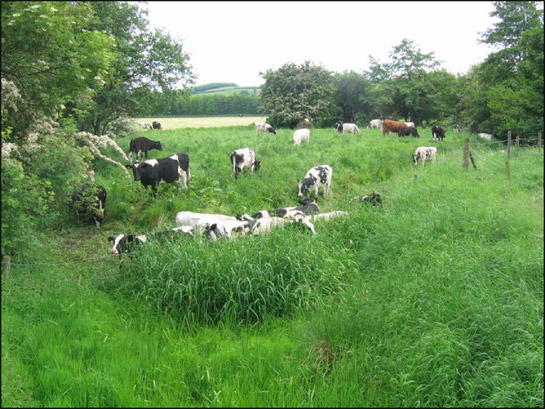
Figure 1: ‘Blue Man’s Bower’ a medieval moated enclosure near Catcliffe lies within seasonally flooded grasslands.
© Nikki Mahadevan – licensed for reuse under a creative commons licence http://creativecommons.org/licenses/by-sa/2.0/
This zone, which is comparatively small in area, is characterised by low relief alluvial landscapes prone to seasonal flooding. The vast majority of the zone consists of enclosed landscapes, although within this there are often large areas of fairly open land with few divisions. Parts of the zone contain regular drainage ditches. The character areas are under a mixture of arable cultivation, with some areas of pasture, whilst elsewhere there is scrub vegetation and woodland.
This zone lies within the historic floodplain of the rivers Rother and Don. Most landscapes are essentially 20th century in origin and have resulted from the alteration of earlier enclosed meadowland (locally known as ‘ings’), which have been drained, agglomerated or removed from later industrial use. Some relict features can be located.
Relationships with Adjacent Character Zones
Both the character areas within this zone represent the only stretches of the historic valley floors of the rivers Don and Rother not currently characterised within industrial, extractive, post industrial or urban zones. As in Sheffield, alluvial landscapes historically proved highly attractive locations for urban development, first because of the opportunities provided to harness the power of flowing water (from the medieval period onwards), and later because of the advantages of large areas of flat open land for developing bulk (canal and later rail) transport systems.
The valley floor areas are also associated with the sites of former coal mines, particularly along the Rother valley, where much of the historic meadowlands were destroyed by opencast coal mining in the later 20th century.
Where meadowland has been enclosed, there are often significant similarities in boundary formation compared with adjacent areas of ‘Surveyed Enclosure’. Systems of drainage are often laid out in a regular pattern along straight field boundaries, creating a landscape similar to the regular enclosures of the surveyed enclosure zone.
Inherited Character
Prior to its industrial development, much of this area was marked by the Ordnance Survey as liable to flooding. This flooding, which, through its deposition of many layers of alluvial silts, influenced the flat valley bottom landforms, is likely to have influenced the valley floors’ historic use as meadowland. Flood plains were eminently suitable for hay making as their propensity to flood made them simultaneously unsuitable for arable cultivation and highly fertile, due to regular deposits of alluvium. In the medieval period, meadow is considered to have been an essential part of the mix of farmland. Rackham (1986, 332) describes it as providing winter feed for animals during the months when pasture grasslands (kept for grazing) were less productive.
The ‘Kilnhurst Meadow Land’ character area contains a number of relict landscape features that indicate the industrial influences acting on valley floor areas in the post-medieval period. The area includes the sites of Swinton Iron and Steel Works (character unit HSY3896), first depicted in 1851 built alongside the South Yorkshire Navigation channel, and later a part of Baker and Bessemer Ltd (Munford 2003, 140-143) – the site was cleared between 1967 and 1986; Kilnhurst Forge (character unit HSY3952), of which parts of the site including goits (races) and the weir survive to give partial legibility of the water powered tilt forge in operation by 1728 (Raistrick and Allen 1939,175); and Kilnhurst Colliery (character unit HSY3752), which operated from 1858-1986 (Taylor 2001, 216), its site now cleared and covered with scrub vegetation.
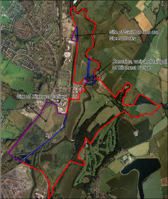
Figure 2: Relict industrial features in the ‘Kilnhurst Meadows’ character area. Note the straight channel of the South Yorkshire Navigation, dug in the late 18th century, running to the west of the character area north of the colliery site.
HEC data © SYAS; Cities Revealed aerial photography © the Geoinformation Group, 1999.
The ‘Junction 33 Meadows’ character area, represents a small relict area of meadowland. This landscape provides a unique impression of seasonally flooded meadowland along the course of the river Rother through South Yorkshire - a landscape that was to be found much more extensively before flood defence and opencast mining led to the canalisation of so much of its course. The Rother at this point appears to have become a braided channel, with relict courses still evident around the main channel, which is now retained by large flood banks. The area includes the Scheduled Ancient Monument Blue Man’s Bower (SMR ref: 260), a medieval moated site with well preserved ditches, possibly associated with an outer moat and fishponds.
Later Characteristics
Boundary loss has impacted on many of the rural character zones within Rotherham district in the late 20th century. The ‘Wetland Enclosure’ zone is no exception to this and, as with other zones, this loss is more prevalent in the east of the district. The ‘Junction 33 Meadows’ character area takes its name from the junction of the M1 motorway with the A630 Sheffield Parkway that is superimposed upon it. The area is also the home of a massive electricity substation linking Sheffield and Rotherham to the National Grid.
Character Areas within this Zone
Map links will open in a new window.
Bibliography
- Rackham, O.
- 1986 The History of the Countryside. London: Dent.
- Raistrick, A. and Allen, E.
- 1939 The South Yorkshire Ironmasters (1690-1750). The Economic History Review Volume 9, No 2 (May 1939).
- Taylor, W.
- 2001 South Yorkshire Pits. Barnsley: Wharncliffe Books.