Late 20th Century Municipal Suburbs
Summary of Dominant Character
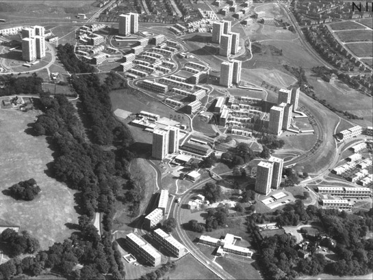
Figure 1: Norfolk Park Estate in 1969.
Aerofilms © English Heritage National Monuments Record
This zone includes a number of large scale mostly high rise municipal housing projects, making much use of non traditional construction techniques and designs. Typically these estates used a mixture of high rise towers and lower rise blocks of ‘maisonettes’, in which many flats shared common utility services, amenity facilities and access routes. Pedestrian and vehicular traffic was generally strictly separated and most estates were designed as independent communities with their own schools, shopping facilities, public houses and places of worship.
Each character area within this zone occupies upwards of 70 hectares of land. These large scale municipal estates comprise the largest examples of the modernist system built housing in Sheffield and were built from the mid 1950s until the early 1970s. The zone does not by any means include all examples of this type of social housing across the city. Estates of up to 50 hectares exist elsewhere in the city, but these largely form infill development within earlier suburbs (for example the estates at High Green and Woodhouse), or formed part of the replanning of the city centre. As such, these smaller estates form components of other zones with more dominant historic characteristics.
At the time of this survey (a baseline of 2003) parts of this zone were already subject to redevelopment programmes that led to their demolition or wholesale redevelopment, particularly at Norfolk Park (largely demolished and rebuilt by 2007) and at Park Hill, subject to a regeneration scheme that aims to realise a City Council vision of a “mixed tenure, mixed use, transformation of Park Hill as a fashionable city centre address”.
There were several similar large scale estates built in Sheffield, including the estates of Kelvin, Woodside, Broomhall and Upperthorpe all of which shared much of the ethos behind the city’s embrace of system built high density housing. These areas now lie within other character zones, as they were demolished prior the commencement of this study.
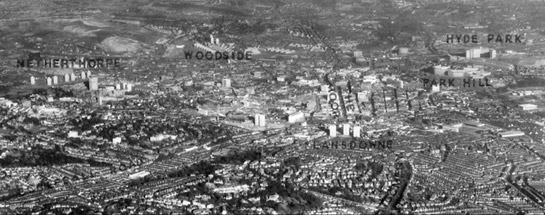
Figure 2: The city architect’s vision was of a ring of high rise developments placed on high points around the city centre, in order to build up “hill top compositions… producing something of the fascination of the Italian Hill Towns” (H. Lambert cited in Sheffield Corporation 1962).
Photo © SCC 1967
The guiding hand behind these developments was the Sheffield City Council Architect’s department, led by J.L. Wormersley, sent en-masse by the council leadership on a tour of European multi-storey housing projects in early 1954. The results of this trip, outlined in a report to council the following year (Sheffield Corporation 1955), was an audacious programme of building around the city on steeply sloping sites that would otherwise prove difficult to develop. The first wave of this work were reviewed by the Architect’s department, with internationalist pride (the text was produced in English, French and Russian), in a landmark publication entitled Ten Years of Housing in Sheffield (Sheffield Corporation 1962). The aspirations behind these developments were neatly summed up in this document by the council’s chair of housing development – “most of our projects feature as important additions to the total environment … the topographical characteristics of the city allow many of them … to be visually related to one another … - the building up of hill-top architectural compositions – is gradually producing something of the fascination of the Italian hill towns” (ibid, 3).
Inherited Character
The estates produced by Sheffield Corporation during this period fall into two main categories – those which replaced existing high density housing (character areas ‘Park Hill and Sky Edge’ and ‘Woodside / Burngreave’ fall into this category) and those which were constructed as new suburbs, on what would today be called green-field sites (‘Jordanthorpe, Batemoor and Greenhill Estates’, ‘Gleadless Valley’ and most of the larger suburban estates, such as those around Woodhouse, fall into this category). These two subdivisions reflect the challenges facing the Architect’s Department in the post -war period, summarised by the council as:
“land shortage, ever increasing distances between homes and work-places, immobility of heavy industry and the urgency for slum clearance” (Sheffield Corporation 1954, 37).
These restrictions led the housing committee to seek out the best ways of building rapidly (using modern materials and prefabrication) and to a high density (using high rise and collectivised designs). Through developing at a higher density than seen with existing housing, the council was able to facilitate the clearance of slum areas without moving too many people away from the areas where they had always lived. In addition, land shortages led the council to develop innovative solutions to the development of land hitherto considered too steeply sloping for economic development, such as at Gleadless Valley, Woodside and Norfolk Park (Sheffield Corporation 1962, 6).
As a rule, the two sub-groups (those built on existing urban sites and those built in ‘virgin’ countryside) have differing profiles of historic legibility. Those replacing earlier terraced and back-to-back housing tended to involve wholesale clearance and re-landscaping, removing most physical traces of earlier landscapes. Those built across rural landscapes were more likely to preserve earlier features, such as mature trees, woodlands and earlier roads. The best examples of this approach are to be found within the Newfield Green / Rollestone district of the Gleadless Estate, where relict ancient field boundaries (already marked by the presence of many mature trees by the time of construction of the estate) are preserved within the development. The estate is also divided into three distinct districts by the retained and ancient Rollestone Wood, which cloaks the steep slopes of the Meers Brook (historically the boundary of Derbyshire and Yorkshire).

Figure 3: The Woodside Estate was created by total clearance of a large area of terraced and back-to-back housing. The entirely new landscape and plan form was separated from an adjoining industrial area (in the foreground) by open space.
Aerofilms 1969 © English Heritage National Monuments Record.

Figure 4: Newfield Green (Gleadless Valley) in the late 1960s. This estate was built across former steeply sloping fields and incorporated former field boundaries and mature woodlands.
Aerofilms © English Heritage National Monuments Record
Later Characteristics
The characteristic developments of this zone have been subject to massive change in the past fifteen years, as public attitudes to high rise and municipal development have changed. Many of the developments of the Womersley period have been fundamentally altered (such as the Netherthorpe cluster of blocks, which were re-clad in the late 1990s) or demolished, such as at Woodside and Norfolk Park. This programme of change was continuing during the life of this project, with Norfolk Park being replaced with a mixed tenure development of private and social rented accommodation.
Character Areas within this Zone
Map links will open in a new window.
- Gleadless Valley (Map)
- Jordanthorpe, Batemoor and Lowedges Estates (Map)
- Norfolk Park Estate (Map)
- Park Hill and Sky Edge (Map)
Bibliography
- Sheffield Corporation
- 1955 Multi Storey Housing in Some European Countries: Report of the City of Sheffield Housing Deputation Sheffield: Sheffield Corporation Architects Department.
- Sheffield Corporation
- 1962 Ten Years of Housing in Sheffield. Sheffield: Sheffield Corporation Architects Department.