Assarted Enclosure
Summary of Dominant Character
This zone is dominated by agricultural landscapes enclosed in irregular patterns. The enclosures within this zone and those of the ‘Strip Enclosure’ zone form the bulk of the surviving landscape still characteristic of the nature of rural land division before the development of Parliamentary Enclosure in the late 18th century. Landscapes originally enclosed in a similar piecemeal fashion but later subject to significant influences from adjacent urban / industrial areas are not included in the zone.
Assart, the term used to describe woodland cleared for cultivation, has been used to describe the character of this zone, although the irregular fields of this zone are probably the result of piecemeal enclosure of moorland, as well as of woodland. Most such piecemeal enclosures date to the medieval or early post-medieval period. The boundaries of the small, highly irregular fields seen in the Mayfield valley are species rich hedgerows (Friends of the Porter Valley 2004, 62-75), a classic indicator of land assarted from woodland (Taylor 1975, 95).
This zone can mostly be found to the west of the modern city of Sheffield, on the lower slopes of the river valleys. The enclosures within this zone vary in their regularity. The most clearly assarted enclosures are irregular ones on the lower slopes, which tend to have hedged boundaries; away from these areas field boundaries are usually of stone. Some enclosures in this zone form strips arranged in furlong blocks that are set at right angles to one another and feature fields with reversed ‘s’ shaped curves. These have been interpreted as examples of small ‘town fields’ attached to small settlements. These probable former strip fields have been included in this zone as they rarely form systems as large or clear as those to the east of the city, described in the ‘Strip Enclosure’ zone.
A dispersed settlement pattern is generally seen within this zone, while nucleated settlements are generally related to areas of former common field agriculture (see the ‘Strip Enclosure’ zone). This relationship has long been recognised in landscape studies (see, for example, the distinction between ‘Ancient’ and ‘Planned’ countryside in Rackham (1986, 4-5), or between ‘nucleated’ and ‘dispersed’ settlement zones in Roberts and Wrathmell (2000)). Data collected for the urbanised area of Sheffield suggests it is a frontier between these two settlement zones, and here there is significant blurring of the two.
Within this zone, enclosure patterns indicative of assartment of both woodlands and moorland and associated farmsteads intermingle with small villages such as High and Low Bradfield, Dungworth and Onesacre, which appear to have been associated with small common arable systems – generally only one former open field can be identified for each of these settlements. Characterisation records interpret a similar pattern extending into the present urban area of the city, as far east as Parson Cross and Wincobank, and as far south as the River Sheaf, with a small nucleated settlement associated with an open or town field at Crookes.
A significant correlation can be seen in the distribution of surviving cruck buildings and areas characterised as piecemeal enclosure, and there is a particular correlation with the assarted enclosure zone. Cruck construction in South Yorkshire generally dates to the 14th-17th centuries (see Ryder 1979c), which corresponds well with the expected date of assarted enclosure.
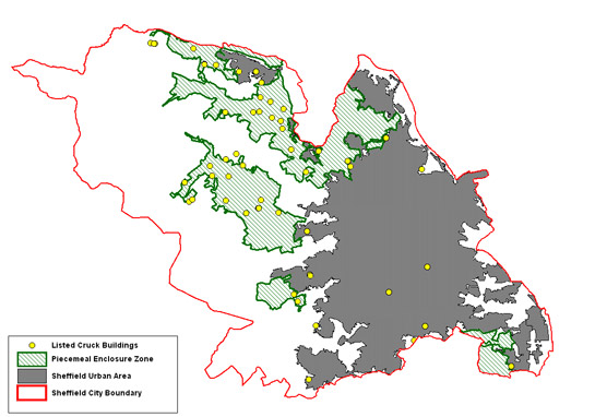
Figure 1: The distribution of listed ‘Cruck Framed’ timber buildings is closely related to that of land enclosed piecemeal before Parliamentary Enclosure - particularly with assarted enclosure.
© SYAS 2008; based on OS mapping © Crown copyright. All rights reserved. Sheffield City Council 100018816. 2007
Inherited Character
Traces of the ancient woodlands from which much of this enclosed landscape was assarted can be seen across this zone (and the ‘Strip Enclosure’ zone, particularly to the north of the city). These woods typically survive on steep slopes where the land was impractical to clear. Where these woodlands have not been replanted during the past 150 years they generally have many legible archaeological features relating to their management for timber, mineral extraction and charcoal burning (Jones 1989).
Later Characteristics
Many elements in this zone, such as its placenames, ancient woodlands, cruck buildings and dispersed settlement patterns all point to origins in the medieval period, or possibly earlier. However, there are also significant modern influences. Major landscape change in this zone began in the late 18th century and continued into the mid 19th century, with the enclosure of remaining common land mostly by Parliamentary Enclosure. Whilst many of the settlements here are recorded either in the Domesday Book or in 13th-14th century documents, the vast majority of surviving buildings are later in date. Many buildings within historic settlement areas are of 18th or 19th century date.
This zone was less attractive than the better connected limestone ridge to the east of Rotherham to developers of ornamental parklands, but small parks dating to the period of parliamentary enclosure survive at Barnes Hall, Chapeltown and Whitely Hall, Ecclesfield.
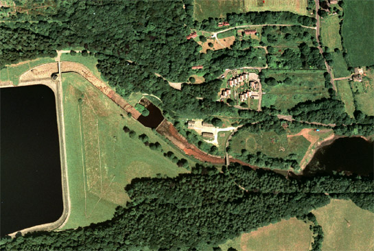
Further major changes, influenced by the proximity and growth of Sheffield, continued from the later 19th century onwards with the construction of Agden (1864), Damflask (1894), Underbank (1907), Broomhead (1929) and More Hall (1929) reservoirs. All these water supply reservoirs were created by the embanking and flooding of steep sided valleys, with historic map evidence showing the loss of irregular enclosure and dispersed farmsteads. Between More Hall and Broomhead reservoirs a prefabricated community created for the labourers on the project is partially legible at Ewden Village.
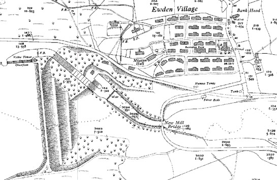
Figure 2: ‘Ewden Village’ was created in the early 20th century for navvy labourers contracted to build the earthworks of Broomhead and Moor Hall Reservoirs (see above); despite much demolition and some redevelopment, a few original prefabricated houses and most of the road network laid out still survive (see below).
© and database right Crown Copyright and Landmark Information Group Ltd (All rights reserved 2008) Licence numbers 000394 and TP0024 and Cities Revealed aerial photography © the GeoInformation Group, 1999.
Character Areas within this Zone
Map links will open in a new window.
- Bradfield Semi Regular Enclosures/ (Map)
- Ewden Valley Irregular Enclosures (Map)
- Mayfield Valley (Map)
- Midhopestones Piecemeal Enclosures (Map)
Bibliography
- FOPV (Friends of the Porter Valley)
- 2004 Field Boundaries in the Mayfield Valley [unpublished]. Friends of the Porter Valley, 42 School Green Lane, Sheffield S10 4GQ.
- Hall, D.
- 2001 Turning the Plough. Midland Open Fields: Landscape Character and Proposals for Management. Northampton: Northamptonshire County Council and English Heritage.
- Rackham, O.
- 1986 The History of the Countryside. London: J.M. Dent.
- Roberts, S. and Wrathmell, S.
- 2000 An Atlas of Rural Settlement. London: English Heritage.
- Taylor, C.
- 1975 Fields in the English Landscape. London: J.M Dent.