Post-Industrial
Summary of Dominant Character
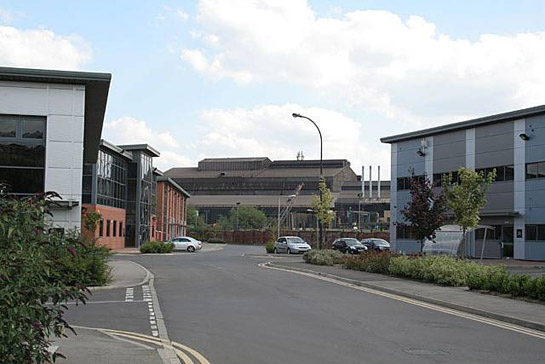
Figure 1: ‘New and Old in Brightside’ – In the foreground are office buildings of Jessop’s Riverside, an early 21st Century commercial development on a former steelworks site. In the background are the Electric Arc melting sheds of Sheffield Forgemasters.
Photo © 2007 Alan Murray-Rust and licensed for reuse under a creative commons license http://creativecommons.org/licenses/by-sa/2.0/
Only in the city centre has development been more intense and resulted in a more diverse and fast evolving historic landscape than within this zone. Contemporary developments of retail parks and multiplex cinemas overlie and are juxtaposed with surviving traces of both earlier heavy industry and earlier semi-rural water powered industries. Underlying all these developments is a dense network of roads and railways, laid out in the later 19th century to connect the works buildings sited here with one another and with the wider world.
The dominant character of this zone (which lies mostly within the Upper and Lower Don valleys, as well as in part of the Sheaf valley) has altered markedly in the years following the collapse of Sheffield’s main industrial base in the late 1970s. The historic character of around 65% of the land within this zone post dates 1970. For most of the 19th and 20th centuries land in this zone was dominated by the manufacture of steel and its processing into tools, castings and rolled products; these industries evolving, in many cases, directly from water powered sites present along the rivers from the late medieval period onwards. In the closing decades of the 20th century Sheffield’s heavy industries were subject to immense change, during which large areas within this zone fell derelict, its buildings obsolete and its workforce redundant.
Efforts to regenerate these areas can be traced back to the late 1980s, with the formation of the Sheffield Development Corporation in 1988 (Hey 1997) and Sheffield’s successful bid to host the 1992 World Student Games. Regeneration development has begun to shift land use within this zone away from industrial use to commercial and recreational activities. Major examples of this in the Don valley include the sports facilities around the site of the Student Games (Don Valley Stadium, Bowl and Arena – all built on the site of the former Brown Bayley Steel Works); the Meadowhall Shopping Centre (on the site of the massive Hecla Steel Works of the Hadfield company); and the Valley Centertainment complex of cinema, restaurants and bowling alley (on the site of the former Attercliffe Common Steelworks and its associated railway sidings). Throughout this zone, many 19th century brick built works buildings and the immense corrugated black sheds that superseded them in the early 20th century have been replaced by newer warehouses, retail parks, car parks - as well as sheds used by specialised light industries that were able to modernise and capitalise on the skills of the established workforce and the presence of Sheffield’s two universities. The corridor to either side of the A57/A630 Sheffield Parkway road, which links the city centre to junction 33 of the M1, is considered as part of this zone as a range of late twentieth century retail, commercial and service developments have grown up to either side of it - on the site of the early 20th century Nunnery coal mine and associated railway goods yards.
The change of land use from industrial to commercial and service sectors has involved other changes in the built character of this area, notably the huge increase in facilities for car parking and public transport (the Sheffield Supertram system was built along both the Upper and Lower Don valleys during the mid 1990s). A further, and generally welcome, change has been a reintroduction to these areas of vegetative cover, especially along the rivers themselves; once heavily polluted by industrial activity, these areas are now championed by city authorities as ‘Green Corridors’.
Inherited Character
The most ancient landscape features of all these zones are the courses of the historic rivers Don, Sheaf and Porter, sitting at the centre of the wide alluvial flood plains that proved so suitable for the development of heavy industries in the 19th century. These rivers all retain traces of their management from at least the late medieval period. The rivers were first harnessed for industrial use for the grinding of edge tools and later for the rolling and processing of steel (see Crossley 1989 for comprehensive details on the survival of these features). Surviving features include weirs, goits, culverts and other features of the systems developed to bypass and harness the energy of these rivers. The buildings and dams associated with water powered industries survive less commonly – the vast majority having been levelled to provide building platforms for later works. However, a handful of sites retain built features, such as the reused mill dam of Rawson’s Mill (now Oxspring Dam), and the surviving rows of vernacular cottages (built as parts of small industrial hamlets) at the sites of Moscar Wheel and Norton Hammer, both in the Sheaf Valley, and again at Rawson’s Mill.
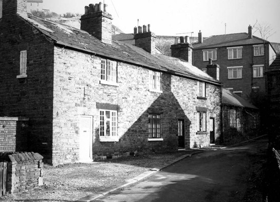
Figure 2: Vernacular cottages, probably at Norton Hammer Lane, thought to have been built for workers at the site of the nearby water powered forge.
© 1968 SCC
Large-scale industrial expansion of this zone began first in the Lower Don valley, following the 1838 opening of the Sheffield – Rotherham Railway, with its terminus at Wicker Station (Hey 1998). This opened the wide valley floor to industrial expansion in the late 1840s, with the foundation of large integrated works by Spear and Jackson (Etna Works) and Charles Cammell and Co. (Cyclops Works), both companies having outgrown smaller sites in the city centre. Earlier mapping shows the flood plains of these rivers generally occupied by irregular enclosures, often identifiable through meadow or ing place-names as places for seasonal grazing. Later development has left few traces of these enclosures.
Further development soon followed, as other established major steel-makers, including Thomas Firth, John Brown, Naylor Vickers and Co. and William Jessop, opened new works. This expansion was represented in an increase in the annual production of crucible steel in Sheffield from 10,000 tons in 1835 to 100,000 tons by 1873 (Barraclough 1976, 13). These industries were mostly developed on a grid iron pattern of streets aligned with the railway (later the Midland Railway); Carlisle and Savile Street, running to the north west and south west of this grid respectively, provided road transport up and down the Lower Don valley. The grid iron pattern of these streets echoed the internal arrangement of the works themselves, where processes were initially developed around square open courtyards, with different processes operating on each side and accessed through a common cart entrance set in a more architecturally ostentatious front range, through which access to the yard beyond could be strictly controlled. This arrangement was developed in tandem with that of typical Sheffield integrated cutlery works, where key concerns were: the need to bring different processes together; the need to provide light at workshop benches; and the need to control secure access for the delivery and despatch of valuable supplies and products (see Wray 2001, 45-53). Later development produced more linear ‘shed type’ buildings, as the steel making technology evolved into bulk processes requiring the internal transport of products by rail transport (Williams 2003).
The later 19th and earlier 20th century saw a rapid succession of technological innovations in the steel industry, these included: the move from crucible and cementation furnace based technologies to the Bessemer furnace; the development of the Siemens open-hearth process, based on methods of bulk production; and consequent enlargements of rolling and forging equipment. These changes are represented in the almost constant modification, addition and enlargement of complexes visible on historic Ordnance Survey plans of the Lower Don valley. In the earlier phases of steel making described above, furnaces and other plant were often an integral part of the buildings around the courtyards, with individual processes clearly identifiable on contemporary etchings and maps by the building forms. As the 19th century progressed, buildings increasingly took the form of substantial brick and later corrugated steel clad sheds, in which a wide variety of different processes and plant could be accommodated (Wray et al 2001, 21).
Each of the types described above can be seen in this zone. Few examples survive in the ‘Norfolk Atlas and Cyclops’ and ‘Hecla Jessops and Staybrite’ character areas, although the brick built front range of the 1856 President Works on Savile Street East is a notable surviving fragment of a ‘courtyard type’ integrated complex. The 1863 West Gun Works (Savile Street East) and the surviving components (dating mostly to the early 20th century) of Cammell’s Cyclops Works (Carlisle Street) are good examples of the move to large ‘shed based’ complexes. The scheduled Darnall Works in the ‘Darnall Canalside’ character area is the largest surviving traditional crucible steel works - developed around 1871-2 for the production of large castings (Harman and Minnis 2004, 200). The level of destruction of earlier steel manufacturing buildings in this area is due not just to their modernisation in the 20th century, but also to the severe recession of the industry by the early 1980s and the remediation of derelict sites by the Sheffield Development Corporation - especially the site of the former Firth Brown company’s works (much of the Norfolk, Atlas and Cyclops group), and the site of the Hadfield company’s Hecla Works (redeveloped as the Meadowhall Shopping Centre).
Elsewhere in this zone the sites of steel works were generally cleared of buildings and left as regenerative scrubland for many years with no new buildings erected until the early 21st century. Examples include the Brightside Steel Works of William Jessop and Co. and Tyzacks Little London Works, both of which evolved from the sites of medieval water powered wheels, known from documentary evidence to have been engaged in the metal trades by at latest the 18th century (see Badcock 2000 & 2002 and Crossley 1989).
All of the character areas in this zone make up major transport corridors, with 19th century railways forming major features of both the Sheaf and Don valleys. Some monumental railway architecture survives, especially along the route of the Midland Railway (dating to the 1880s) in the Sheaf valley - where bridges, embankments and retaining walls are built from local stone. The disused Heeley Station, for instance, is raised some 20 feet above the surrounding land by a massive retaining wall forming a definite ‘edge’ to the adjacent residential suburb. At least one further disused station survives at Brightside, in addition to a large number of either reused, derelict or active areas of railway sidings (including the large surviving marshalling yards at Tinsley dating to the mid 20th century). In Albert Road, Heeley, are the remains of a Sheffield Tramways depot and stables, built in 1878 to house tram cars and the horses that pulled them.
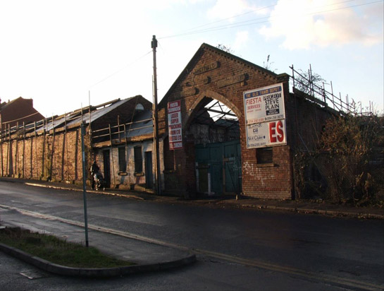
Figure 3: Albert Road Horse Tram Depot in 2006
© SYAS.
Later Characteristics
As this zone is typified by much of the most recent developments to affect the Sheffield landscape it is perhaps best to consider it as a growing landscape, highly likely to expand over the next decade. During the life of the characterisation project development work has been in progress in all the character areas of this zone.
Character Areas within this zone
Map links will open in a new window.
- Blackburn Meadows and Tinsley Viaduct (Map)
- Darnall Industrial Canalside (Map)
- Don Valley Sports and Leisure (Map)
- Greenland Industrial Estate, Darnall (Map)
- Hecla, Jessops Brightside and Staybrite (Map)
- Parkway (Map)
- Lower Porter Valley (Map)
- Lower Sheaf Valley (Map)
- Norfolk, Atlas and Cyclops (Map)
- Tinsley Park and Airport (Map)
- Upper Don Valley (Claywheels Lane to Club Mill) (Map)
Bibliography
- Barraclough, K.
- 1976 Sheffield Steel. Sheffield: Sheffield City Museums.
- Badcock, A.
- 2000 Archaeological Appraisal of land at Jessops Riverside, Brightside, Sheffield. Sheffield: ARCUS unpublished report 595.1.
- Badcock, A. 2002
- Archaeological Appraisal of land adjacent to Broadfield Road, Sheffield. Sheffield: ARCUS unpublished report 658.1.
- Harman, R. and Minnis, J.
- 2004 Sheffield: Pevsner Architectural Guide. New Haven and London: Yale University Press
- Hey, D., Olive, M. & Liddament, M.
- 1977 Forging the Valley. Sheffield: Sheffield Academic Press.
- Williams, A.
- 2003 The Typology of Industrial Buildings with Reference to the Steel Trades in Sheffield, 1750-1900. Thesis (PhD). University of Sheffield.
- Wray, N.
- 2000 ‘One Great Workshop’: The Buildings of the Sheffield Metal Trades (main report). York: English Heritage.
- Wray, N. Hawkins, B. Giles, C.
- 2001 ‘One Great Workshop’: The Buildings of the Sheffield Metal Trades (popular publication). London: English Heritage.