Surveyed Enclosure
Summary of Dominant Character
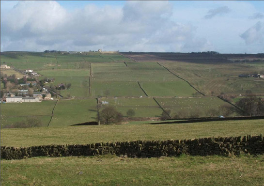
Figure 1: A typical landscape of Surveyed Enclosure at Loxley Chase to the west of Sheffield. Former moorland was converted to grassland pasture and enclosed by straight dry-stone walls according to plans approved by the Commissioners of the Wadsley and Loxley Chase Parliamentary Act Enclosure awarded in 1789 (date from English 1985)
© 2006 SYAS
This zone is dominated by land enclosed by straight-sided walls or, less often in Sheffield, by hedgerows laid out to a regular pattern. In the Sheffield district, surveyed enclosure survives on a large scale almost exclusively to the west of the city, on areas of higher ground. Further large tracts of land were enclosed in a similar way elsewhere in the district, but these have since been lost to urbanisation. The majority of the surviving landscapes of this type are found between the city and the moorland zone.
This landscape is largely the result of enclosure by Parliamentary Award in the late 18th and early 19th centuries, when moorlands were converted to grassland pasture. Most roads in this zone are of standard and regular widths and are laid out on straight courses. These characteristics are typical of roads laid out by Parliamentary Enclosure surveyors nationwide (Hindle 1998). Such standardisation was a typical feature of enclosure countryside and can be seen as representative of a shift from vernacular to designed processes of landscape formation. Rational standardisation was also a feature of contemporary turnpike roads. In this area, Ringinglow Road, dating to the mid 18th century, represents a well-preserved example. The landscape includes a related 18th-19th century hamlet at Ringinglow, with an inn and toll house.
Surviving settlement in this zone is mostly contemporary with, or post dates, the surrounding enclosures. Settlement is generally dispersed, with the typical farmstead being built from local stone in the 19th century and extended with modern pre-fabricated barns in the 20th century. An exception to this is the small, nucleated village of Bolsterstone. This earlier settlement, first mentioned in 1375 (Smith 1961, 257), is included within this zone as a result of the surveyed enclosure of its surrounding former open or town fields.
On the western extremes of this zone enclosures are larger in size and are often reverting to moorland types through abandonment of grazing over the past 20 years. On the eastern fringes of the zone there are influences from the nearby western suburbs of Sheffield.
Inherited Character
The land making up this zone represents a large-scale systematic programme of landscape design and change. The processes involved dramatically altered the character of the area in social as well as physical terms, as the common resource of the heather moors was transformed into managed grasslands, only accessible to their owners and tenants. This land became, in terms of capital, a private commodity rather than a communal resource. The physical transformation of the land involved, for the most part, a complete change from what was already present. In moorland areas the land was often ploughed for the first time in thousands of years (Taylor 1975, 143), this area having been last exploited for agriculture in the Bronze and Iron Ages. As in many other parts of the country, this process may often have included the deliberate levelling of existing (prehistoric) earthworks, which probably accounts for the relative lack of earthwork monuments in this zone, when compared to higher areas to the west, which remained un-converted to grassland.
Evidence for the earlier moorland landscape is generally too subtle to be significantly legible within this zone, although where larger enclosures have not been converted to grassland or where abandoned fields are reverting to moorland flora an impression of the former landscape character can be gained. Surviving features from earlier periods mostly exist on the fringes of this zone, where lower slopes, especially around streams, preserve fragments of earlier land uses. Good examples of this can be found at Copperas Farm (near Ringinglow), where remains of a mid 18th century lead-smelting cupola survive, and at Whirlow Hall Farm, which includes fragments of buildings relating to older piecemeal enclosure landscapes to the east (now mostly under suburban development).
Later Characteristics
It is impossible to separate the landscape history of this zone from that of the city of Sheffield. The most notable effect has been the creation of the large water supply reservoirs, to meet the needs of the rapidly growing urban population: Rivelin Dams (c.1845); Dale Dike Reservoirs (c.1864 re-opened 1874); Langsett Reservoir (c.1905); and Midhope Reservoir (c.1907) are all within this zone. The most remarkable of these historically is Dale Dike, which failed in 1864 causing destructive flooding in the Loxley and Don valleys as far as Brightside and resulted in the loss of 240 lives, 693 animals, 100 buildings and 15 bridges (Walton 1984, 204). The reservoirs are associated with plantation woodlands, which were created to stabilise the valley sides and reduce silting in the reservoirs (Bevan 2003, 54). The construction of the reservoirs also saw the demolition of a number of adjoining farms, which were seen as a pollution threat to the water supply (ibid, 10).
Within this zone, the transition to a suburban landscape becomes blurred as you get closer to Sheffield. The southern slopes of the Rivelin valley near Crosspool are an excellent example of this, where parliamentary enclosure patterns (probably dating to the enclosure of common grazing land by the Hallam Enclosure Award of 1805 (English 1985, 62)) have been superimposed with extensive allotment gardens, cemeteries and a golf course. At Long Line on Dore Moor, limited ‘ribbon development’ suburbanisation has taken place along a typical enclosure period road, since the 1930s.

Figure 2: Long Line, laid out by the Dore Moor Enclosure Award of 1822 (Kain et al. 2004).
© 2006 SYAS
Modern agricultural changes such as the creation of large scale ‘prairie’ fields, for the efficient mechanised production of cereal crops, have had a less drastic effect on this landscape than on enclosure landscapes elsewhere in South Yorkshire, where arable farming is the main land-use. However, there have been some losses of boundaries in this area as a result of intensification. Most surviving farmsteads have seen significant enlargement in the 20th century, with the erection of large prefabricated sheds (mostly) for the housing of livestock.
Character Areas within this Zone
Map links will open in a new window.
- Bolsterstone and Upper Midhope Surveyed Enclosure (Map)
- Bradfield Surveyed Enclosure (Map)
- Dore Moor and Ringinglow Parliamentary Enclosures (Map)
- Strines Moorland Edge (Map)
- Upper Rivelin Parliamentary Enclosures (Map)
Bibliography
- Bevan, W.
- 2003 The Upper Derwent: Long Term Archaeology in the Peak District. Thesis (Phd). University of Sheffield.
- English, B.
- 1985 Yorkshire Enclosure Awards. Hull: University of Hull.
- Hindle, P.
- 1998 Roads that ramble, and roads that run. British Archaeology, 31 [online]. Available from: http://www.britarch.ac.uk/ba/ba31/ba31feat.html [accessed 04/08/2008].
- Kain, J.C., Chapman, J. and Oliver, R.
- 2005 The Enclosure Maps of England and Wales Cambridge, CUP
- Long, D.J., Chambers, F.M. and Barnatt, J.
- 1998 The Palaeoenvironment and the Vegetation History of a Later Prehistoric Field System at Stoke Flat on the Gritstone Uplands of the Peak District. Journal of Archaeological Science, 25, 505-519.
- Smith, A.H.
- 1961 The Place-names of the West Riding of Yorkshire: Part One. Cambridge: Cambridge University Press.
- Taylor, C.
- 1975 Fields in the English Landscape. London: J.M. Dent and Sons Ltd.
- Walton, M.
- 1968 Sheffield: Its Story and its Achievements. Otley: Amethyst Press.
1 see Long et al (1998) for details of environmental evidence from the East Moors of the Peak District, which suggests that much land at this altitude was agriculturally viable and actively exploited as such throughout later prehistory.