Grid Iron Terraced Housing
Summary of Dominant Character
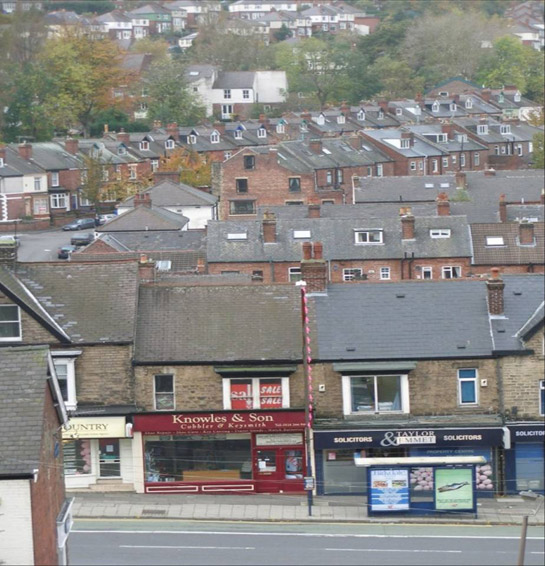
Figure 1: A typical high density landscape of slate roofed brick properties in the ‘Sharrow Vale and Hunters Bar’ character area
© 2005 SYAS
This zone was first subject to large-scale urbanisation in the period 1864-1919, with the development of housing on regular grid street patterns. The dominant housing type is generally standardised terraced property, although a distinct hierarchy of building types can be discerned. This ranges from simple two–up-two-down designs, through to large townhouses providing dedicated scullery kitchens, larders, entrance hallways and bathrooms in addition to a small privately enclosed garden area. For the smaller properties, it is common for there to be regular passageways between the houses, opening on to communal yards that are shared between groups of the houses; this design has been explained as a continuation of patterns established through the longer established tradition of constructing domestic courts of back-to-back houses (Muthesius 1982). Another characteristic feature of Sheffield grid iron terraced housing is that properties tend to be stepped down along the slope, giving a broken rather than continuous roof line.
The character areas within this zone also frequently include estates developed by Freehold Land Societies, where semi-detached and detached properties of more unique designs and grander proportions can be found. These estates show a greater variety of building styles as here land was first divided into plots that were then developed with individual properties. This reflects the fact that the primary motivation behind the subdivision of these areas was the acquisition of land by a wider sector of society, rather than development for commercial gain; land society developments enabled larger numbers of people to vote, as voting rights were linked to property ownership (Harman and Minnis 2004, 282). These societies provided an important impetus to the development of 19th century suburbs. Once established, a society bought up land and divided it into individual plots, members of the society paying a monthly contribution to costs and charges for making roads, with the society being wound up once costs for the land had been met.

Figure 2: Land Society development in Norton Woodseats in 1894
© and database right Crown Copyright and Landmark Information Group Ltd (All rights reserved 2008) Licence numbers 000394 and TP0024
Excellent examples of land society development in this zone have been recorded in Norton Woodseats, Crookes, Heeley, Walkley and Meersbrook. Historic map evidence shows that often these areas did not develop past the building of a few large villas – the ‘building plots’ being shown as undeveloped n some places for 40 years or more. In many cases, final development of these areas was undertaken in standard terraced form.
Housing in this zone is associated with contemporary institutional buildings, especially churches and primary schools built by the Sheffield School Board. Many also feature Vestry Halls, e.g. at Meersbrook Park Road, Cemetery Road (Sharrow), and Crookesmoor Road, built for the collection of rates, administration of local neighbourhoods and to provide local places of assembly.
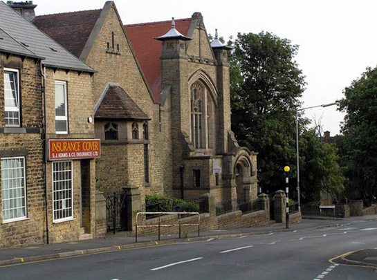
Figure 3: Former St Luke’s Methodist church, Crookes Road
© 2004 Ivor Hutchinson. Licensed for reuse under a creative commons license - http://creativecommons.org/licenses/by-sa/2.0/
These suburbs were provided with shops and pubs, often sited on street corners. In addition, earlier settlement cores such as Owlerton, Crookes, and Woodseats became commercial centres, as did important termini of the tramway networks, such as at Firth Park. Purpose built variations of larger terraced properties were provided with shop fronts on the ground floor frontages. Most of Sheffield’s terraced suburbs also featured at least one larger co-operative society store.
Many of these suburbs absorbed earlier elite houses built in the 18th century by industrialists and merchants. Associated parkland was often set aside by the municipal authority or provided by benefactors to form centrepieces to the new suburbs, such as Meersbrook, Hillsborough, and Firth Parks. Further recreational space was set aside in most of these areas for allotment gardens, the largest area of plots being at Meersbrook.
Contemporary cemeteries can be found in Burngreave, Crookes and Norton, which are typical of their period, with sandstone mortuary chapels and geometric layouts of avenues mirroring the grid iron patterns of the surrounding housing.
The suburbs that make up this zone are all to be found in close association with industrialised river valleys. All were provided with connections on Sheffield’s tramway network, allowing commuting from residential districts to more distant workplaces. Some dispersed small industrial buildings can be found within most areas of this zone, especially in the transitional areas between this and other zones, particularly the older established residential or industrial zones (for instance in the Porter valley at Sharrow Vale).
Inherited Character
The most obvious early landscape features in this zone tend to be found where earlier hamlets have been absorbed by the 19th century suburban developments. Good examples of this process can be found at Crookes, in parts of Norton Woodseats, Woodseats Dale and at Owlerton.
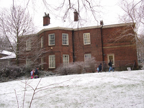
Figure 4: Meersbrook House in Meersbrook Park
© 2005 SYAS
The historic parklands of Meersbrook, Firth Park and Hillsborough preserve earlier designed and semi-natural woodland landscapes around large previously private residences of the 18th century, although all were modified on their municipalisation. The parks themselves also preserve legible traces of earlier agricultural land-uses. A number of other 18th and early 19th century large residences are a feature of this zone, good examples being Abbeydale House; Mount Pleasant and 10 Sharrow Lane - formerly the Charnwood Hotel (Highfields); Pisgah House (Walkley); Abbeyfields House; and Page Hall (now the Abbey Grange nursing home).
Suburbanisation of these areas was frequently as a result of the organic extension of earlier industrial suburbs - Sharrow, Highfields and Abbeydale Road represents the steady advance of housing southwards along the Sheaf valley from the older hamlet of Little Sheffield. Generally, older terraces can be discerned closest to these earlier cores, such as the late 18th or 19th century listed terraces on Barnabas Road - some of the oldest in the city.
Development of new terraces took place over a variety of earlier landscapes. Where earlier land enclosure formed a regular pattern, then development has sometimes fossilised earlier patterns, for instance in the former Club Gardens in Sharrow; the parliamentary enclosures of Sharrow and Pits Moors; and the enclosed strips to the west of Crookes’ historic core. However, where regular patterns were not present then old boundaries appear to have been cleared and the new grid patterns laid out wholesale across the land.
Later Characteristics
Later development within this zone has focussed on the sites of former brickworks and quarries (that produced building materials for the original phase of development). Frequently these sites have seen infill housing or commercial developments – often retaining dramatic former quarry faces through the sandstone geological sequences. Good examples of such reuse can be found at Brincliffe and Woodseats. Elsewhere there has been considerable redevelopment of earlier allotment garden sites for housing, mostly small areas of semi-detached housing, in the early to mid 20th century.
Housing clearance has, by and large, been restricted to areas of older housing in other zones. In Sheffield this process was undertaken on a large scale across grid iron terraced areas in the 1960s and 1970s and has been separately described in the ‘Terraced Housing Clearance Areas’ zone. The most notable exceptions are at Highfields and Lowfields, where three blocks of late 19th century grid iron terracing were demolished in the 1970s, and within Burngreave and Page Hall, where small areas have (and continue to be) subject to clearance programmes.
However, social change over the past one hundred years has led to significant changes to the way houses in this zone are occupied and maintained. Most notably, the now widespread phenomenon of multiple car ownership has had a significant effect on the streetscape, with off-road opportunities for parking near completely absent and on-road opportunities limited by the inherent short street frontage of terraced properties. Within properties the most notable change has probably been the introduction of bathrooms and toilets in the main living accommodation, rather than contained within the back yard. Changes in property maintenance impacting on the general character of these area include the widespread replacement of wooden doors and windows with double glazed uPVC units; the replacement of welsh slate roofing with concrete and other composite materials; and the introduction of TV and satellite aerials.
Changes in attitudes and practices concerning religion and schooling are also manifesting themselves in the changing characteristics of former institutional buildings in this zone; buildings originally provided for these purposes are now often put to re-use as community centres, clubs or youth centres.
Character Areas within this Zone
Map links will open in a new window.
- Crookes, Walkley and Broomhill (Map)
- Highfields, Sharrow and Abbeydale Road (Map)
- Hillsborough (Map)
- Meersbrook (Map)
- Norton Woodseats (Map)
- Pitsmoor, Burngrave, and Firth Park (Map)
- Sharrow Vale and Hunters Bar (Map)
- Wadsley Bridge (Map)
Bibliography
- Harman, R. and Minnis, J.
- 2004 Sheffield. New Haven and London: Yale University Press
- Muthesius, S.
- 1982 The English Terraced House. New Haven: Yale University Press.