Terraced Housing Clearance Areas
Summary of Dominant Character
This zone is made up of areas characterised by large scale clearance of mostly 19th century terraced housing during the middle to late 20th century. While many original street patterns, institutional buildings, public houses and some housing survives throughout these areas, clearance and redevelopment has left a significant mark on the historic character. Most of these areas feature large quantities of late 20th century municipal housing. These include system built estates constructed in materials new in the 1950s and 60s and, from the mid 1970s onwards, more traditional estates of low rise housing. Open spaces are also regular features of these areas; the characterisation project has shown that over half the green spaces created in Sheffield in the last 30 years are former areas of housing.
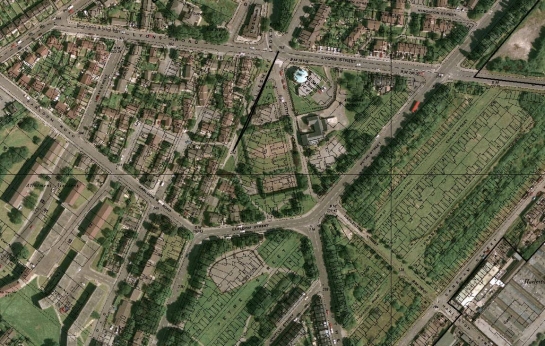
Figure 1: This 1999 aerial photograph overlain with the 1891 OS map shows the extent of 20th century housing clearance and redevelopment in the ‘Shirecliffe, Woodside, Spital and Lower Burngreave’ character area.
Cities Revealed Aerial Photography © the GeoInformation Group, 1999; historic map data © and database right Crown Copyright and Landmark Information Group Ltd (All rights reserved 2008) Licence numbers 000394 and TP0024
Geographically this zone is found most commonly to the north of the city, in close relationship to the sites of former heavy industry in the Upper and Lower Don valley floors. This close industrial relationship is most strongly felt in the Attercliffe, Infirmary Road and to a lesser extent in the Darnall areas, where redevelopment since housing clearance has focussed on the expansion of this established industrial area across previously wholly residential or mixed residential and industrial areas. Elsewhere, redevelopment replaced older housing forms with often radically new architectural forms, such as the large estates of Kelvin, Woodside, Upperthorpe and Burngreave. The most radical of these (Kelvin and Woodside) have already themselves been subject to further clearance programmes in the early 1990s and 2003-4 respectively.
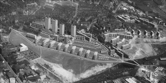
Figure 2: The Woodside / Burngreave Estate shortly after construction in the 1960s
© SCC
Inherited Character
Attercliffe, Darnall and Heeley all grew as suburbs around earlier villages; the plan form, boundary features and occasionally buildings of which all form important parts of the present historic environment of these places. In the case of Attercliffe and Darnall, these villages were likely to have developed as nucleated settlements by at least the medieval period. Early mapping shows these villages developing in a linear form, with thin narrow plots set perpendicular to main roads. Such plan form layouts are generally interpreted as indicative of some level of planning during the medieval period. Surrounding these settlements were open townfields that had become fossilised by later semi-regular piecemeal enclosure by the early 19th century (Sanderson 1835). The resulting thin strip fields sometimes formed units for later development, for example at Station Road, Darnall.
Early mapping around Heeley (e.g. Jeffreys 1775 and Sanderson 1835) indicates that the later suburbanisation of this area joined up a number of earlier separate hamlets (these earlier settlements are now known as Heeley Bridgehouses, Lower Heeley (or Heeley Bottom), Middle Heeley, Upper Heeley and Heeley Green). These settlements had a much less regular plan form than that seen at Darnall and Attercliffe and there were no clear large scale open field systems in this area. It seems possible that the nucleation of these settlements was a response to the growth of the metal trades industries that flourished here by the early 17th century (see Kingston 2004).
Legible traces of each of these villages survive in property boundaries, occasional buildings (such as the cruck barn at Wilson Place, Heeley, and the early 17th century Hill Top Chapel at Attercliffe), and the less regular building lines within the former historic cores. The pattern, observable in the ‘Grid Iron Terraced Zone’, of historic cores becoming the later central places of suburbs continues within this zone, with the historic cores of Attercliffe, Darnall and Heeley still forming the basis of the commercial shopping area of each today.
Suburbanisation of this landscape had begun in earnest by the mid 19th century, following the development of bulk steel making processes in the Lower Don and Sheaf valleys. Development processes in this area were similar to those acting within the well preserved suburbs of the ‘Grid Iron Terraced Housing’ zone, although the properties developed in this zone tended to be earlier, with large numbers of back-to-back courts. The vast majority of these were cleared from the inter-war period (1919-1939) onwards as Sheffield City Council embarked on the development of major public housing schemes away from traditional industrial areas - such as those to be found in the ‘Early to Mid 20th Century Municipal Suburbs’ zone.
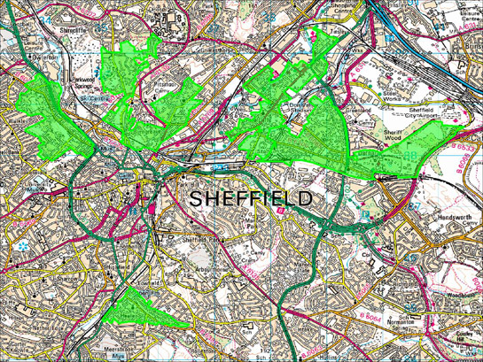
Figure 3: The distribution of this zone corresponds to the first areas developed with terraced housing outside the city centre © SYAS based on Ordnance Survey mapping
© Crown Copyright, All Rights Reserved, Sheffield City Council 100018816. 2008
Despite the high levels of housing clearance in these areas (and their resultant late 20th century regeneration) strong aspects illustrating their development in the 19th century are legible throughout. As is the case within the ‘Grid Iron Terraced Housing’ zone, housing within this zone was generally developed in parallel with contemporary institutional buildings, especially churches and primary schools built by the Sheffield School Board. The vast majority of these buildings survive but many have developed new uses as a result of the clearance of their related housing. The zone also features administrative Vestry Halls (such as those to be found at Attercliffe Hill Top and in Burngreave), built for the collection of rates, administration of local neighbourhoods and to provide local places of assembly.
Legible traces of late Victorian suburbanisation are most obvious in the pockets of un-cleared terraced housing that can be found in much of this zone. For example, a corridor of Heeley was cleared in the 1960s and 1970s, when an urban dual carriageway was proposed; outside this corridor examples of 19th century character survive. These include the institutional buildings along Gleadless Road; the land society areas of Artisan View and Heeley Bank; the 3 storey terraced properties fronting London Road South/ Chesterfield Road at Heeley Bottom; and the Sheaf Bank Works, formerly of shovel makers C.F. Skelton.
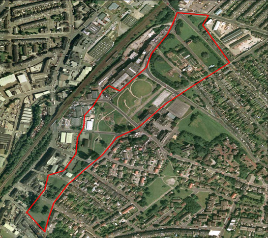
Figure 4: This corridor of land through Heeley was cleared in anticipation of a never built road scheme. The land was regenerated in the late 20th century by local community groups as a City Farm and public park.
Cities Revealed Aerial Photography © the GeoInformation Group, 1999
Upperthorpe has a similar surviving residential area around Daniel Hill and Blake Street, as well a small historic core area featuring a 19th century public baths and library, as well as one of the city’s best preserved areas of mixed housing and industrial buildings (once typical of much of the city centre) from Montgomery Terrace Road to Hoyle Street. Similar characteristics, although with more redeveloped plots, can be found within the grid iron streets between Infirmary and Penistone Road. Upperthorpe also features the reused remains of the late 18th century General Infirmary, surrounded in the late 20th century by a modern supermarket and car park.
19th century character in lower Burngreave is mostly restricted to the Spital Hill area where older terraces survive behind later shop fronts and the Spital Hill Works (formerly of edge tool maker John Sorby) clings to the hillside. To the south and east of Petre Street and Ellesmere Road a well preserved grid iron layout survives from the late 19th century. Despite the redevelopment of much of the original residential and industrial buildings, its earlier character is visible with the preservation of a handful of buildings, including at least two public houses.
Attercliffe has seen the largest shift away from housing to industry following redevelopment. In common with the other areas of this zone, surviving historic character is best demonstrated within the main commercial and historic core. Elsewhere earlier character is restricted to a surviving grid street pattern, occasionally featuring earlier industrial or institutional buildings and with public houses often surviving on street corners - retained to serve the later industrial buildings.
Darnall retains the largest areas of surviving terraced property in this zone, with grid iron groups of later bylaw terraces around Stainforth and Darnall Roads. The Darnall character area also includes an 1859 cemetery and the 1894 High Hazels Park as related suburban landscapes.
Later Characteristics
Following the initial clearances of housing in this area, major projects of housing reconstruction were undertaken, mostly by Sheffield City Council, including the massive deck access Kelvin Flats and the Woodside Estate; both of these have since been demolished. The regeneration of these areas, in an effort to improve their many social problems, remains a major influence on their physical form. These areas are currently being considered as part of the Pathfinder ‘housing market renewal’ programme.
Character Areas within this Zone
Map links will open in a new window.
- Darnall (Map)
- Heeley (Map)
- Post Suburban Attercliffe (Map)
- Shirecliffe, Woodside, Spital and Lower Burngreave (Map)
- Upperthorpe and Langsett / Infirmary Road (Map)
Bibliography
- Jefferys, T
- 1775 The County of York [Map] 1inch:1mile. Reproduction- Margary
- Sanderson, G
- 1835 Twenty Miles Round Mansfield 2001 Reprint, Derbyshire County Council.