18th-19th Century Industrial Grids
Summary of Dominant Character
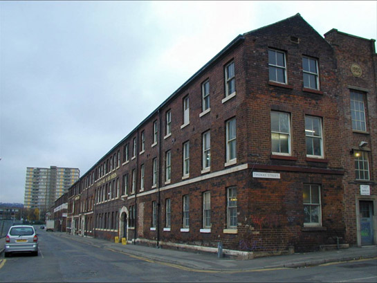
Figure 1: Eyewitness Works, in the ‘Devonshire Grids’ character area - typical of the large integrated cutlery works that dominated this zone in the late 19th century
© 2007 SYAS
This zone represents surviving areas of industrial development around the historic core of Sheffield. This zone grew rapidly in a ‘C’ shaped band around the city centre, laid out with regular grid iron street patterns from the late 18th century until the mid 19th century. The building density of the zone gradually intensified over the 19th century. Typical early development included mixed-use light industrial buildings, often buildings connected to the light trades of cutlery and tool making, which had ranges of workshops around rectangular central courtyards (Wray 2000, 46), and high density residential properties, often built back-to-back around domestic courts (Belford 2001,110). Streets were generally developed in a hierarchal pattern, with wider streets, which originally commanding the higher land values, occupied by the public showrooms and offices of the industrial works, and narrower back lanes providing service access and land for cheaper residential development.
The original buildings of this area survive less well than the grid pattern of streets, with large numbers lost in the early to mid 20th century due to a combination of industrial modernisation and housing clearance policies and centrally planned road schemes (see ‘Late 20th Century Replanned Centres’ Character Zone). The earliest survivals are in the ‘Sheaf and Porter’ character area. Howard Street and Arundel Street both retain late 18th century, three storey brick built residential properties from the Duke of Norfolk’s early scheme (Harman and Minnis 2002, 136). Venture Works (103-105 Arundel Street) represents the industrialisation of one of these Georgian residences by the construction, by 1850, of workshop ranges enclosing a narrow courtyard to the rear of the former house (Wray 2000, 57).
On a grander scale were the integrated works (see Wray 2000, 44-53), where a variety of separate processes could be accommodated within a large courtyard based complex, often featuring stationary steam engines to power grinding and forging processes. Examples include the Butcher Works, Sellers Wheel, Challenge Works and Sterling Works in the ‘Sheaf and Porter’ character area; the Beehive Works and Eyewitness Works in the ‘Devonshire grid’ character area; and the Portland Works, Stag Works, Harland Works and Clifton Works in the ‘Little Sheffield and Bramall Lane’ character area.
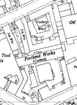
Figure 2: Portland and Stag Works in the ‘Little Sheffield and Bramall Lane’ character area
© and database right Crown Copyright and Landmark Information Group Ltd (All rights reserved 200X) Licence numbers 000394 and TP0024
The ‘Central Don Valley Floor’ character area includes a significant group of integrated works connected to the light trades around Kelham Island, including Cornish Place Works (built for electroplating); Wharncliffe Works and Green Lane Works (stove and fire grates); and Brooklyn Works (saws and files). This character area marks a geographical transition between areas dominated by Sheffield’s light trades of cutlery and tool manufacture and areas dominated by the heavy trades, concentrating on the production and refinement of steel as well as the production, forging and rolling of large castings. Prior to the 1850s, steel making remained on a small enough scale to operate alongside the lighter trades in premises of similar size (see ‘Industrial’ Character Zone), and examples can be found in trade directories and other historic sources of steel making facilities in most parts of this zone.
The ‘Central Don Valley Floor’ character area, however, (which includes an area of grid iron extension to the immediate north west of the ‘Crofts’ character area) proved to be the site of some notable developments in the steel manufacturing sector. The area still retains significant upstanding examples of the buildings of the steel trade, which predate the relocation of companies such as Charles Cammell, Spear & Jackson, John Brown, and Thomas Firth and Sons to the Lower Don Valley in the 1840s and 1850s into the complexes that would later form the heart of the city’s bulk steel production. Large classically influenced office buildings connected to Globe Works (Penistone Road) and Sheaf Works (adjacent to the canal basin) survive from this phase. This area also contains the demolished site of important early integrated steelworks at Spital Hill (Wicker Iron Works) and Millsands (Marshalls / Naylor Vickers, River Don Works). Despite the larger size of the processes within these works, the layout tended to follow the same spatial principles of the smaller cutlery workshops, with narrow ranges of buildings positioned around a central courtyard. This allowed work-pieces to easily pass between various specialised craftsmen.
Harder to read in the present landscape of this zone is the substantial history of residential property that was established here before the 1860s. Historic Ordnance Survey maps show large numbers of mostly back-to-back workers housing throughout this zone.
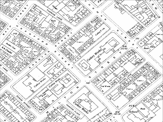
Figure 3: This extract from 1954 OS 1:1250 mapping of part of the ‘Devonshire Grids’ character area shows the significant density of back to back property built in this zone in the mid 19th century
© and database right Crown Copyright and Landmark Information Group Ltd (All rights reserved 200X) Licence numbers 000394 and TP0024
Most domestic properties in this zone were cleared in the early 20th century, as part of a co-ordinated programme of demolition and re-housing that created the municipal cottage estates of Parson Cross, Shiregreen and Manor (see ‘Early to Mid 20th Century Municipal Suburbs’ Character Zone).
Rare survivals include 98 and 100 Milton Street, shown as back-to-back property on historic mapping but converted in the late 20th century to ‘through houses’ (property owner pers. com 2005). Court 4 behind these properties is an almost unique survival, although it is unusual in only serving four original properties – most Sheffield courts would form the shared communal space for between 10 and 18 households. The only other survivals of small workers houses in this zone are less typical, although nos. 4-14 Canning Street (built ‘blind back’ against workshop ranges, resulting in ventilation, illumination and access being possible only on one elevation of the dwelling) give a good impression of the typical street frontage of this style of three storey, early 19th century property (see Harman and Minnis 2004, 127).
Inherited Character
Up until the 18th century the expansion in the population of Sheffield, resulting from the burgeoning growth of its industries (Pollard 1956, 172-180), was accommodated chiefly in and around the historic core of the medieval market town through the intensification of building densities within existing burgage plots, and through the infilling of remaining open spaces within the town (see the ‘Complex Historic Town Core’ Character Zone). During the 18th century significant steps were taken to expand the town by the development of land in the ‘Crofts’ area to the north of the town and in the area between Burgess Street and Cambridge Street to the south west (Hey 1991, 87-89). These developments (whilst on a small scale) set the pattern for the development of the later grid iron developments of this zone, particularly in the system of leases that was used to facilitate development.
Leases of between 99 and 900 years were typical and under this system (AHP 2003, 16) owners of large estates employed professional surveyors to plan the subdivision of their land into prospective building plots. Plans of Sheffield drawn in the late 18th and early 19th centuries show large areas of this zone in this state, with areas annotated as building ground or showing route of proposed street. This system allowed the landowner to exploit the value of his land by levying a ground rent on the developed land according to its value in this early state. Subsequent developers could then develop buildings and charge their own increased ground rent (representing the improvement made to the value of the land by their new building). The system could often include further tiers of sub letting. This pattern of lease and sub lease was particularly well matched to the conditions of labour in the cutlery trades. In this sector a complex system, where independent craftsmen (known as Little Mesters from the late 19th century onwards [see Symonds et al 2002, 19]) rented working space within larger buildings had been in existence for many years1. As each tier of ground rent had a value that could be used as security against borrowing, the system greatly facilitated the financing of large-scale industrial development (ibid).
The first major example of the application of the building lease system in this zone was instigated by the Duke of Norfolk, in the area between the historic town and the River Sheaf - land recorded by the survey of John Harrison in 1637 as Alsopp Farme (Scurfield 1986, 163-164). This survey recorded the farm as demesne land of Sheffield Manor let to tenants at will. The land lay just inside the boundary of the former deer park and is likely to have been one of the earliest parts of the park to be subdivided and let as farmland. In the 1770s the Norfolk estate commissioned James Paine to prepare plans for a grid pattern of streets here (Harman and Minnis 2004, 135). It was intended that the leases be taken up by developers for high class residential property, but it seems that few were interested and by the 1790s leases were being arranged with cutlers for smaller dwellings; restrictions on ‘offensive trades’ (ibid, 136), originally intended to protect the new development, had been removed by 1800.
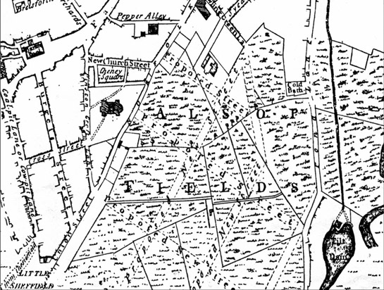
Figure 4: Detail of Fairbank's 1771 plan of Sheffield showing the 'Proposed Streets' of the Duke of Norfolk's development scheme.
Historic maps of Sheffield from the late 18th to mid 19th century show the rapid proliferation of grid patterned developments. As well as the progressive expansion of the Alsop Fields grid pattern, separate grids were drawn up for speculative development across Little Sheffield Moor (enclosed from common land by the Ecclesall Enclosure Award (Fairbank 1788, No I Plan) and further parts of the Church Burgesses land to the west of the town centre. Most of these were laid out by the Fairbanks family of surveyors who dominated the local profession from 1739 - 1850 (Sheffield City Libraries 1936), and careful analysis of the patterns from separate phases suggests that each phase was carefully planned to ensure its streets intersected as efficiently as possible with earlier grids. The connectivity of the resultant layout facilitated the industrial specialisation of the Sheffield light trades, where work pieces passed from trade to trade between separate workshops as different processes undertaken to bring a finished product to completion were completed by various craftsmen.
Later Characteristics
The grid patterns of this area, which offered new opportunities for manufacturers to develop integrated complexes, began to be outgrown by the largest steel manufacturers by the mid 19th century. Thomas Firth (whose Portobello Works opened near West Street in 1842) and John Brown’s first Atlas Works (opened in 1846 on Furnival Street) had both moved to the Lower Don Valley by 1852 (Belford 2003). Not only did the Lower Don floodplain offer large open spaces over which large new complexes could be laid out, but the newly constructed Manchester, Sheffield and Lincolnshire Railway provided a means to transport increasingly large products to their markets.
The light trades continued here into the 20th century by increasing the production of specialist precision instruments in the face of ever cheaper imports of cutlery from labour markets less resistant to mechanisation than Sheffield’s. Walton, writing in 1968, noted a recent revolution in the industry,
“already the traditional ways of apportioning work have been altered, and it has been found that machines of the right kind can, after all, produce first-class cutlery” (Walton 1984, 268).
These changes in the working conditions of the light trades appear to have been accompanied by the first major clearances of older courtyard works, workers housing and tenement factories. Walton remarked on the “clearance of whole streets” (ibid), leading to major reductions in the spaces available for rent to independent craftsmen. Following World War II, there was considerable investment in this zone, which now contains significant quantities of post-war industrial buildings. These were constructed following the City Council’s reorganisation of land use through the application of planning policies intended to concentrate light industrial activity into certain areas of the city (Sheffield City Council 1945, 28-29).
Many new cutlery factories can be seen marked on the 1950s Ordnance Survey mapping. These works reflect the introduction to the industry of new working practices based on production lines and mechanisation. The old courtyards are no longer present, instead a wide single storey space is generally provided, with lightweight prefabricated roofing, under which a range of machinery could be accommodated, lit by electric and natural light. By the appendix to the fifth edition of Walton’s book, written in 1984, the failure of these changes to protect the skills and workforce of the light trades is painfully apparent with a fall in the workforce quoted as being from “25,000 to somewhere between 2,000 and 4,000” a level which recent estimates suggest has remained stable (Symonds et al 2002, 108).
The post-war period also saw significant severance of parts of this zone, caused by the redevelopment of the severely bomb damaged Moor and the construction of the Civic Circle and inner ring road. This, combined with the decline of the light industries of this zone in the second half of the 20th century, has stimulated a further loss of industrial character.
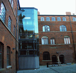
Figure 5: Butcher Works in the ‘Sheaf and Porter’ character area, converted to residential use in the early 21st century
© 2007 SYAS
Most recently, a profound change in the residential profile of this zone has emerged. Following clearance of former industrial buildings, land has become available for new ‘city living’ and student accommodation, resulting in the construction of mixed-use commercial and residential buildings, such as West One. These developments have been accompanied by conversion and reuse of some of the most important surviving integrated works, including Butcher Works, Truro Works, Brooklyn Works and Cornish Place. Common to many of these developments, whether situated in new or historic buildings, is a concern to provide strict segregation of the communal and private space of the development with the public space of the street, mediated by entry systems and CCTV security systems (Ratcliffe 2007). It is interesting to how the traditional form of the courtyard works has been adapted to meet the requirements of the modern ‘security community’.
Character Areas within this zone
Map links will open in a new window.
- Canal Basin and Victoria Station (Map)
- Central Don Valley Floor (Map)
- Devonshire Grids (Map)
- Little Sheffield and Bramall Lane (Map)
- Sheaf and Porter Central Industrial (Map)
Bibliography
- Belford, P.
- 2001 Work Space and Power in an English Industrial Slum. In: A. Mayne, and T. Murray, The Archaeology of Urban Landscapes: Explorations in Slumland. Cambridge: Cambridge University Press, 106-117.
- Belford, P.
- 2003 Advanced Art, Imperfect Science: The Archaeology of Cementation and Crucible Steelmaking in Sheffield 1700-1850. Ironbridge Archaeology Monograph 1. Oxford: BAR Archaeopress.
- Fairbank, W.
- 1788 Ecclesall Enclosure Plan [parchment folio]. Available from: Sheffield Archives, Shoreham Street Sheffield [CA363].
- Hey, D.
- 1998 A History of Sheffield. Lancaster: Carnegie Publishing Ltd.
- Pollard, S.
- 1956 The Growth of Population. In: D.L. Linton (ed.), Sheffield and its Region: A Scientific and Historical Survey. Sheffield: British Association for the Advancement of Science.
- Ratcliffe, D.
- 2007 Changing Townscapes of South Yorkshire: Sheffield’s Housing Since the 1960s. In: J. Schofield (ed.), Modern Times. Conservation Bulletin 56. London: English Heritage.
- Sheffield City Libraries
- 1936 Guide to the Fairbank Collection. Sheffield: Sheffield City Libraries.
- Symonds, J. (ed.) Beauchamp, V. and Unwin, J.
- 2001 The Historical Archaeology of the Sheffield Cutlery and Tableware Industry 1750–1900. – ARCUS studies in historical archaeology 1. Sheffield: ARCUS.
- Walton, M.
- 1984 Sheffield: Its Story and its Achievements (Fifth Edition). Otley: Amethyst Press.
- Wray, N.
- 2000 ‘One Great Workshop’: The Buildings of the Sheffield Metal Trades (main report). York: English Heritage.
1This pattern was established by the later 17th century at water-powered grinding wheels, where cutlers would generally rent a ‘seat’ or ‘trow’ for as long as necessary to process their wares (Hey 1991, 102). Most ‘wheels’ (referring in Sheffield to any building used for the grinding of cutlery) were in turn generally rented from a landlord (often the Duke of Norfolk). This pattern of renting working space is known to have continued at all levels of the later urban industry, with even large owner occupied works such as Globe and Sheaf works thought to have been renting out bench space to ‘outworkers’ (Symonds et al 2002, 60).