Strip Enclosure
Summary of Dominant Character
This zone is dominated by agricultural landscapes enclosed in a semi-regular pattern. This semi-regular pattern resulted from the piecemeal enclosure of strips within the open field arable system. In the medieval period, large open areas of land were cultivated in long thin strips that would be ploughed separately into ridges. Often, the practice of turning the oxen plough team at the end of each strip would produce a characteristic curving reversed ‘s’ shape pattern. This pattern was often fossilised in later piecemeal enclosure boundaries that were laid out around individual or groups of strips (Taylor 1975, 78-80).
This zone occurs principally to the east of the city; this is likely to be due to the lower altitude of this side of the city, making it more suitable for arable cultivation, than that of the assarted enclosure zone to the west. Where the agricultural landscape survives in this area (where it has not been overbuilt), there has been some boundary loss.
Landscapes originally enclosed in a similar piecemeal fashion but later subject to significant influences from adjacent urban / industrial areas are not included in this zone.
The two types of piecemeal enclosure pattern found within Sheffield (‘Assarted Enclosure’ and ‘Strip Enclosure’) are closely related to different settlement patterns. Dispersed settlements are generally found within areas of assarted enclosure, whilst nucleated settlements are related to areas of former common field agriculture. This relationship has long been recognised in landscape studies as a classic example of the relationship between social and landscape patterning - see for example the distinction between ‘Ancient’ and ‘Planned’ countryside in Rackham (1986, 4-5), or that drawn between a ‘nucleated’ and ‘dispersed’ settlement zones in Roberts and Wrathmell (2000). Data collected for the urbanised area of Sheffield suggests it is a frontier between these two settlement zones, and here there is significant blurring of the two.
As well as Sheffield itself, nucleated villages with elements of planning can primarily be found to the east and south of the city, at Attercliffe, Beighton, Chapeltown, Dore, Ecclesfield, Greenhill, Handsworth / Handsworth Woodhouse, Mosborough, Norton and Tinsley. All of these villages were associated with large systems of former open fields; most are likely to have been operating three fields – a pattern common across the English Midlands (see Hall 2001, 13-15).
Only a small proportion of the land within this zone remains in agricultural cultivation – mostly in the ‘Moss Valley’ and ‘Grenoside and Birley’ character areas. Agricultural intensification has led to some boundary loss across much of this zone, although characteristic enclosures and boundaries remain in places, most notably around Bridle Stile near Mosborough, where some very long and narrow strips are preserved. Such examples provide strong evidence for the medieval cultivation methods of open fields.
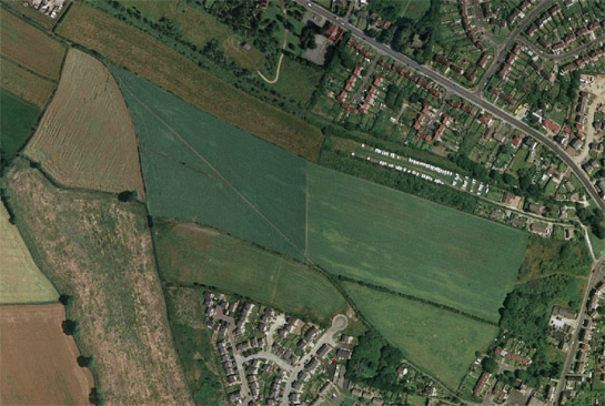
Figure 1: The enclosure pattern surviving around the ‘Bridle Stile’ footpath in Mosborough (see above - running across the fields) dates to the piecemeal enclosure of strip units from a former open field, before the Parliamentary Enclosure of remaining common arable in the parish in 1796 (see Figure 2 in Stroud 1996).
Cities Revealed aerial photography © the GeoInformation Group, 2002ã and database right Crown Copyright and Landmark Information Group Ltd (All rights reserved 2008) Licence numbers 000394 and TP0024
The tradition of open field agriculture appears to have functioned on an increasingly small scale as the landscape gains altitude to the west of the city. Assarted enclosures associated with dispersed settlement become the norm here, but there appear to have been small scale common arable systems based on one or two ‘town fields’ around settlements such as Low Bradfield, Dungworth and Onesacre. From examining characterisation records for past landscape use we can interpret a similar pattern of small scale open or town field agriculture extending into the present urban area as far east as Parson Cross and Wincobank, and as far south as the River Sheaf, with a small nucleated settlement associated with a town field at Crookes.
Inherited Character
Traces of ancient woodlands can be seen across this zone and the ‘Assarted Enclosure’ zone, particularly to the west and north of the city. These woods typically survive on steep slopes where land has been impractical to clear. The distribution of ancient woodlands is clearly related to these zones of piecemeal enclosure. Where these woodlands have not been replanted during the past 150 years they generally have many legible archaeological features relating to their management for timber, mineral extraction and charcoal burning (Jones 1989).
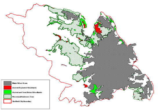
Figure 2: The two piecemeal enclosure character zones (Assarted and Strip Enclosure) include most of the City of Sheffield’s ancient woodlands. Most of these woodlands are to be found on steeply sloping land, historically difficult to cultivate.
Image © SYAS 2008; Ancient Woodland data © English Nature (used with permission).
Later Characteristics
There has been some boundary loss within the ‘Strip Enclosure’ zone but this has occurred on a less significant scale than that seen within the ‘Agglomerated Enclosure’ zone. The biggest influence appears to be the dominant 20th century land use, with land suitable for intensive arable cultivation most likely to have been subject to boundary loss.
Across the zone there has been modern expansion and alteration to the surviving farm buildings. This has often been in the form of the introduction of modern corrugated shed-type barns, more suited to the mechanised agricultural practices of the later 20th century than traditional farm buildings.
Character Areas within this Zone
Map links will open in a new window.
- Dore and Totley Relict Enclosures (Map)
- Grenoside / Birley Countryside (Map)
- Moss Valley Countryside (Map)
- Onesacre and Worral Former Townfields (Map)
Bibliography
- Hall, D.
- 2001 Turning the Plough. Midland Open Fields: Landscape Character and Proposals for Management. Northampton: Northamptonshire County Council and English Heritage.
- Jones, M.
- 1989 Sheffield’s Woodland Heritage. Sheffield: Sheffield City Libraries.
- Rackham, O.
- 1986 The History of the Countryside. London: J.M. Dent.
- Roberts, S. and Wrathmell, S.
- 2000 An Atlas of Rural Settlement. London: English Heritage.
- Taylor, C.
- 1975 Fields in the English Landscape. London: J.M Dent.