Grid Iron Terraced Housing Zone
Summary of Dominant Character
This zone is characterised by blocks of conjoined terrace housing built in a regular grid pattern, generally dating to between 1900 and 1938. The built form of each house in a row is highly regular, with a standardised elevation usually including one widow for each of the two storeys and a front door below a roof that slopes away from the street. Internally most of these houses will have two main rooms per storey, plus a large attic room lit by skylights. Most examples in Doncaster feature a rear offshoot, normally housing a kitchen and bathroom. Access to the rear of the houses is typically via a rear alleyway - the arrangement commonly seen in Sheffield of regular passageways through houses opening on to communal yards shared between houses is rare in Doncaster. In Sheffield this design has been explained as a continuation of patterns established through the longer established tradition of constructing domestic courts of back-to-back houses (Muthesius 1982) – a tradition which seems to have been largely absent from Doncaster. The few back-to-back properties identifiable on historic maps of Doncaster tend to be built in isolated rows, with open access at both sides. Most properties in this zone appear to have been laid out with separately enclosed private rear spaces accessible either from the house or the alley. In Mexborough both ‘passageway’ and ‘alley’ types can be located.
Grid patterns of streets and alleyways are common across this zone with the hierarchy of main thoroughfares and lesser side streets often reflected in the property sizes on each, the main streets generally laid out with the largest houses. Features marking the higher status of some terraces include tree-lined streets, bay windows, decorative stone lintels over doors and windows, ridge tiles and finials, and bands of differently coloured stone or brick used to elaborate front elevations.
Non-residential character included within this zone, due to its intimate relationship with surrounding housing, includes parks, allotments, churches and chapels, integral terraced shops, and schools. These features are generally contemporary with the laying out of the housing.
Relationship to Adjacent Character Zones
As is typical across many parts of Britain industrialised in the later 19th century, the development of large areas of terraced housing in Doncaster is closely related to large-scale heavy industries and the need to quickly and affordably build sufficient housing to accommodate workers and their families. Each character area of this zone is adjacent to sites of significant industrial employment in the late 19th and early 20th century, for example the Plant Works west of Doncaster town centre and the industries along the river Don through Mexborough and Doncaster town centres.
Areas of terraced housing are a feature of many of the earliest phases of ‘Planned Industrial Settlements’, especially at Denaby Main, where the majority of the town was built according to strict grid iron terraced patterns before its near complete demolition and rebuilding from 1967–1987 (Jones 1999, 123-142). Grid iron terraced housing also formed the earliest phases of mining villages at Bentley and Instoneville (Askern). Whilst much of the other housing in the colliery villages and (significant amounts of 20th century municipal housing) continued to be built as conjoined rows, most of this housing was in non grid iron patterns and represents a development, rather than a continuation, of the character type described here.
Inherited Character
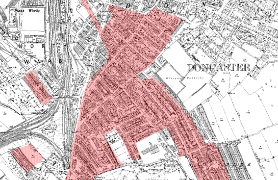
Figure 1: 1891 OS Map extract showing Doncaster's earliest area of grid iron terraced housing (shaded).
© and database right Crown Copyright and Landmark Information Group Ltd (All rights reserved 2008) Licence numbers 000394 and TP0024
The earliest terraced suburb in Doncaster was developed over approximately 50 hectares, bounded by the medieval suburb of St Sepulchregate, Glasgow Paddocks, the Plant Works/Station, and Doncaster Cemetery between 1851 and 1894. This suburb, probably related to the inflow of workers to Doncaster’s Plant Works, was developed across earlier allotment and market gardens. Nearly all this area was cleared in the late 20th century; the area, now occupied by dual carriageways, commercial buildings and the Balby Bank Estate forms part of the ‘Late 20th Century Replanned Centres’ zone.
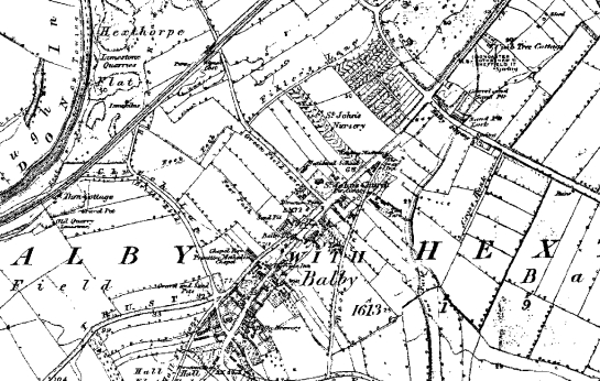
While terraced housing developed outside the historic cores of Doncaster and Mexborough, at Balby an earlier linear village and its surrounding perpendicular strip field landscape was progressively absorbed into a terraced suburb.
1852
1894
1938
Figure 2: Development of grid iron terracing across an earlier strip enclosure landscape in Balby.
© and database right Crown Copyright and Landmark Information Group Ltd (All rights reserved 2008) Licence numbers 000394 and TP0024
The development of Balby does not appear to have fossilised many of the buildings of the earlier settlement, although the road patterns do preserve significant legibility of the earlier plan form. The main axis of the early settlement appears to have been Low Road, with most buildings depicted in 1775 (Jeffreys) and in 1854 (Ordnance Survey) focussed here. High Road / Warmsworth Road are part of a former turnpike route between Doncaster and Rotherham. Early terraced development appears to have focussed on the stretch of this road from Balby to Doncaster and gradually colonised the strip fields to either side. Many of these side roads fossilise the layout of former fields, an example being St John’s Road, first depicted in 1894 but built within a plot marked as gardens in 1854.
Housing in this zone frequently developed one or two streets at a time over many years. Strip fields formed ideal rectangular plots in which to fit developments of this scale. Patterns influenced by former fields can be found in blocks between Holly Avenue, Wellington Road (Bentley Rise) and around Hyde Park in the ‘Balby Terraces’ character area. The straight boundaries of parliamentary enclosure landscapes proved even more suitable. The block of perpendicular streets from Milton Road to Victoria Road in Mexborough all align with enclosures defined by the Parliamentary enclosure of Dolcliffe Common, undertaken in 1861 (Goodchild 1997, 206).
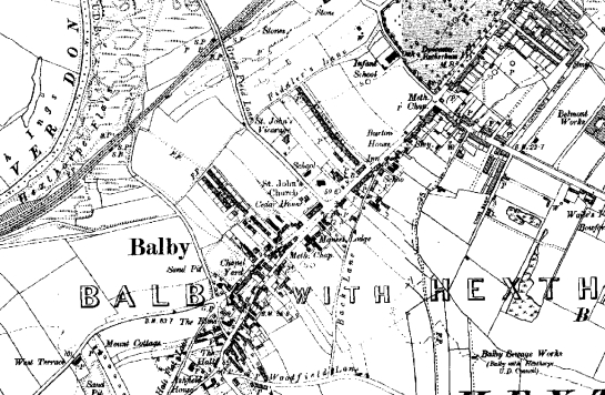
An exception to the patterns of legibility seen above can be demonstrated within the ‘Wheatley Terraced’ character area, where development appears to have been more wholesale within the former grounds of Nether Hall. These houses were built between 1882 and 1892 and are reputed to be the first terraced houses built in Doncaster with inside toilets (Kessen 2006).
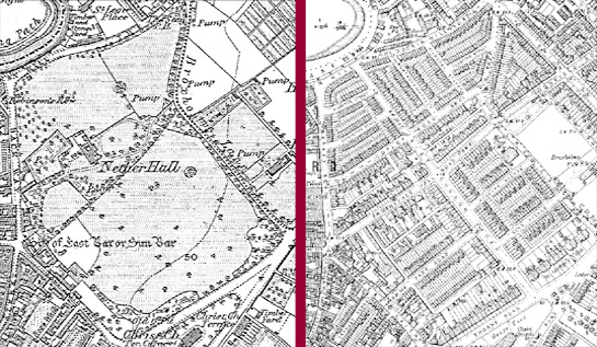
Figure 3: Wheatley Terraced character area; the parkland of the 18th century Nether Hall (left, in 1852) was developed wholesale with terraced housing, leaving the hall itself an isolated island of earlier character. It survives, in much altered form, as part of a complex of Doncaster MBC offices.
© and database right Crown Copyright and Landmark Information Group Ltd (All rights reserved 2008) Licence numbers 000394 and TP0024
Suburbanisation of this area fossilised few boundary patterns, although the hall itself, thought to have been built on the site of a medieval manor house (Hunter 1828, 51; Magilton 1977, 32) survives at the core of present municipal offices.
Later Characteristics
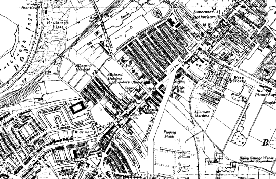
The majority of this zone continues to be characterised, at character unit level, by developments with clear pre Second World War origins. However, 50 hectares (about 1/7th of the total zone) has been recorded in the project database as being characteristic of the post-war period. Some of this land represents clearance of the oldest 19th century terraced housing stock for newer housing, but the majority represents infilling of remaining open spaces, particularly remaining agricultural land, allotment gardens and former quarries and brick pits.
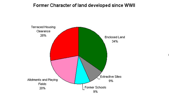
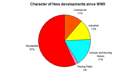
Figure 4: Changing character of units developed since WWII
© SYAS 2008
Character Areas within this Zone
Map links will open in a new window.
- Balby Terraces (Map)
- Bentley Rise Terraced (Map)
- Hexthorpe Terraces (Map)
- Mexborough Terraces (Map)
- Wheatley Terraced (Map)
Bibliography
- Goodchild, J.
- 1997 The Enclosure of Mexborough. In: B. Elliott (ed.), Aspects of Doncaster: Discovering Local History. Barnsley: Wharncliffe Publishing, 199-208.
- Jones, M.
- 1999 Denaby Main: Development of a South Yorkshire Mining Village. In: B. Elliott (ed.), Aspects of Doncaster 2: Discovering Local History. Barnsley: Wharncliffe Publishing, 123-142.
- Kessen, D.
- 2006 We don’t want to loo-s important piece of history. Doncaster Free Press [online]. Available from: www.doncasterfreepress.co.uk/doncaster-star-news/We-don39t-want-to-loos.1919186.jp [accessed 18/01/08].
- Magilton, J.
- 1977 The Doncaster District: An Archaeological Survey. Doncaster: Doncaster Museum and Arts Service.
- Muthesius, S.
- 1982 The English Terraced House. New Haven: Yale University Press.