Wetland Enclosure
Summary of Dominant Character
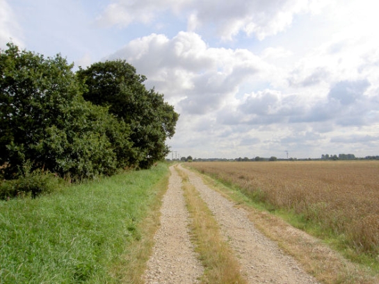
Figure 1: The landscapes of this zone are typified by straight boundaries and roads, drainage ditches, flat open arable fields and wide skies.
Photo ‘Green Lane’ West End, Doncaster © 2007 Steve Fareham –licensed according to a creative commons license- http://creativecommons.org/licenses/by-sa/2.0
The main landscape divisions within the zone are: large-scale wide open areas of arable farmland, enclosed by regular patterns of man-made drainage ditches; valley floor pastures alongside the rivers Don and Went; and the vast landscapes of scarred peat making up the remnants of the lowland raised mires of Thorne and Hatfield Moors.
This zone is characterised by low relief alluvial landscapes. ‘Enclosed Land’ is by far the most dominant Broad Type of character unit recorded, occupying 78% of the zone, with the relict moorlands making up the next most frequent Broad Type of character unit.
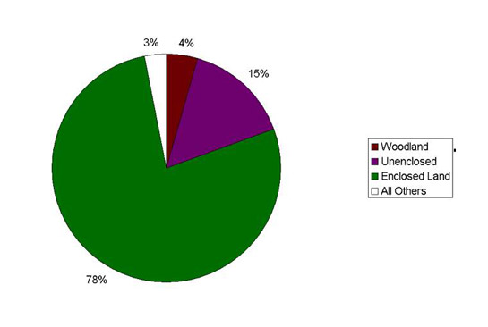
Figure 2: Wetland Enclosure zone by Broad Type of character unit
The arable farmlands here are a large-scale modern agricultural landscape, characterised by a highly regular pattern of drainage ditches. Linear features such as roads and field boundaries often follow the same course for many miles. Settlement within this landscape is typically dispersed, with small brick-built farmsteads associated with each land holding. Occasional rectilinear plantation woodlands fit within the overall plan form of enclosures. Some landscapes belonging to non-agricultural character types, particularly those related to gravel extraction, are also present.
The valley floor character areas are principally located in the historic flood plain of the River Don. Dominating this area is the main channel of the river and a number of subsidiary channels designed to facilitate navigation or improve the drainage of surrounding land. This improvement of the valley floor began in the 18th century, with the construction of the South Yorkshire Navigation. Cuts were made to straighten meanders of the river and to avoid non-navigable features such as weirs and sand beds (Hopkinson 1956; Holland 1980, 32). The river and canal system is accompanied by man-made flood embankments, used to allow areas of normally dry land to act as floodplain. As a result of this expectation to flood, this land was generally set down as permanent pasture. Land within the natural flood plain of the river, but protected (in theory) by the man-made embankments, was generally drained by ditches and managed for arable production.
The relict moorland landscapes at Thorne and Hatfield constitute the two largest lowland raised mires in Britain. As such, these areas are of special scientific interest for their biological and archaeological. They are characterised by open expanses of wet, boggy peat. The moorlands are subdivided by regular grid patterns of drainage ditches, within which are further regular patterns of trench-like cuttings. Some parts of the moors support large stands of woodland.
The earliest large-scale drainage landscapes visible today were created following an agreement in 1626 between Charles I and the Dutch engineer Cornelius Vermuyden (Hey 1979, 129). Vermuyden’s drainage scheme proved highly unpopular with much of the local population, who not only disputed the new rights of ownership allocated to the participants in the scheme through direct action, but also complained of increased flooding in surrounding lands (Dinnin 1997a, 26). Much of this secondary flooding was not alleviated until the second great period of drainage in this zone, during the period of Parliamentary Enclosure - in Doncaster between c1750-c1850.
Relationships with Adjacent Character Zones
The former wetland character of these landscapes means that areas of historic nucleated settlement are largely absent from the interior of this zone, although their edges are rich with settlements, such as Hatfield, Thorne, Bawtry and Hatfield Woodhouse.
The typological division between this landscape and the adjacent landscapes of the ‘Surveyed Enclosure’ zone is sometimes indistinct, where common drainage patterns intersect landscapes of uncertain earlier character.
Post-drainage exploitation within areas of former wetland has resulted in the development of character areas belonging to other zones, for instance: the sites of Hatfield and Thorne Collieries; Finningley Airport; and the motorways and junctions of the M18 / M180, belonging to the ‘Extractive’ and ‘Post-industrial’ character zones.
The development of the transport corridor along the valley floor of the River Don has resulted in areas of ‘Wetland Enclosure’ alternating with ‘Industrial’, ‘Extractive’ or ‘Post-industrial’ character areas. This trend is most visible through the limestone ‘Don Gorge Valley Floor’ area and through the main Doncaster conurbation. Nucleated settlements, with a historic relationship to the valley floor area, include Fishlake, Braithwaite, Kirk and South Bramwith, Thorne Waterside, Barnby Dun, Kirk and Long Sandall, Doncaster, Sprotbrough, Conisbrough, Old Denaby and Mexborough.
The present extent of the moorland within this zone is the result of historic processes of conversion (through drainage, dry warping, mineral and peat extraction), giving a close relationship with enclosed and extractive landscapes.
Inherited Character
Drainage: The drained arable farmlands within this zone have parallels with other large-scale drained landscapes in the UK, chiefly the East Anglian Fens, but also the Somerset Levels, Romney Marsh and the Norfolk Broads.
Historically most of the area that is now arable farmland was characterised by “watery marshes, fens, bogs, moors and other grounds of like nature” (Gardner 2005, 5). Exploitation of much of this area was under the control of the crown from 1347, as a royal hunting park (Hatfield Chase), effectively preventing any medieval attempts at drainage (Dinnin 1997a, 22). Beyond the Chase, land was subject to intercommoning (ibid) - the important resources of peat, grazing pastures, wood (especially in areas of carr), fowl, and fish being shared by the surrounding parishes.
Prior to its drainage, the largest area of wetland was around Thorne and Hatfield Moors. It is this area that is likely to have formed the bulk of Hatfield Chase. There is some evidence (see ibid, 20-21) that the earliest attempt to drain this area was made either during the Romano-British period or in the early centuries following the Norman Conquest, with the digging of the Turnbridge Dike. A plan made in 1639 by Thomas Arlebout (in Miller 1997, 3.3) shows that the essential form of the ‘Hatfield - High and Low Levels’ and ‘Dikes Marsh and Moorends’ character units, defined by the project, dates to the agreement in 1626 between Charles I and the Dutch engineer Cornelius Vermuyden (Hey 1979, 129). In these units it is possible to identify the sinuous courses of former streams on aerial photographs.
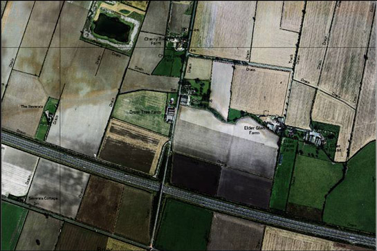
Figure 3: An example of irregular linear settlement following a relict watercourse in the Hatfield Levels.
Cities Revealed aerial photography © the GeoInformation Group, 1999 overlain by modern OS mapping © Crown copyright. All rights reserved. Sheffield City Council 100018816. 2007
As in the Cambridgeshire Fens [where they are known as ‘roddons’ (Page et al 1936)], these palaeo-channels provide higher and more stable ground for building, due to the presence of fluvial gravel deposits. This has led to the development of linear collections of farmsteads, all coinciding with a palaeo-channel; this pattern is still visible on aerial photographs (at OS grid references SE7019; SE7119; SE7219).
Previous character types: Earlier character variations in the intercommoned wetlands and flood plains within this zone can be gleaned from analysis of placename elements indicative of land-use. Common examples of such elements are summarised in the table below.
| Placename element | Meaning | Examples |
|---|---|---|
| ‘Ing’
| A meadow – especially one by the side of a river and low-lying1 | Low Ings, Sykehouse; West Ings and Peaker Ings, Stainforth; Town Ings, Fishlake; Bentley Ings; Old Ings, Kirk Bramwith; Ings Field Rossington; Long Sandall Ings; Newton Ings; Hexthorpe Ings.
|
| ‘-holme’ | A piece of flat low-lying ground by a river1 or stream water-meadow2 | Lindholme, Almhome, Reedholme and Rands Ruskholme |
| ‘Moor’ | A boggy area, especially one that is peaty and dominated by peats and sedges3 | Thorne Moor; Hatfield Moor; Tween Bridge, Pighill and Nun Moors (Thorne Cables); Thorne Moorends; Hatfield Moor; West Moor; Rushy Moor, Owston. |
| ‘Carr’ | Marsh ground covered with brush wood1 A wood of alders4 | Huggin Carr; Almholme Carr; Potteric Carr; Carr Doles, Rossington; Black Carr, Cantley; Loversall Carr; Balby Carr; Wadworth Carr; and Stancil Carr. |
1. Shorter Oxford English Dictionary 1973
2. The Place-names of the West Riding of Yorkshire, (Smith, 1969)
3. Merriam Webster Online Dictionary
4. (Rackham 1986)
The valley floor areas are dominated by ‘ing’ and ‘-holme’ place names, both generally taken to be indicative of riverside meadow-land. In the medieval period, meadow is considered to have been an essential part of the mix of farmland. Rackham (1986, 332) describes it as providing winter feed for animals during the months when pasture grasslands (kept for grazing) were less productive. In areas of arable production, like much of the Doncaster area, this feed was largely for animals kept for motive power. Flood plains were eminently suitable for hay making as their propensity to inundation made them simultaneously unsuitable for arable cultivation and highly fertile, due to regular deposits of alluvium.
Much of the valley floor is now characterised by straight edged enclosure, consisting of both hedged and ditched boundaries. It is probable that many of these enclosures originated with Parliamentary Awards. Bentley Ings is a good example of this, where the surviving enclosure pattern is typical of enclosure period layout, with straight roads and similarly aligned field boundaries throughout. It is probable that its enclosure dates to the 1830 Bentley with Arksey Enclosure award, which dealt with “Open fields, intermixed inclosures, ings, meadows, pastures, commons, wastes, commonable lands” (English 1985, 15 - my emphasis ). The frequent presence of ‘ings’ in the classes of land recorded as enclosed by Parliamentary Award and the frequency of straight-sided enclosure in locations with ‘ing’ placenames throughout the borough is strong evidence that meadowland was generally a resource held in common.
‘Moor’ place names are associated with three main locations in the zone: Thorne Moors; Hatfield Moor; and West Moor. ‘Moor’ is generally taken in modern use to indicate “uncultivated hill land” (Rackham 1986, 305), however, historically it has also been associated with lowland ‘turf-moors’ indicating land covered by a layer of peat. There is a technical difference between Hatfield and Thorne Moors, on the one hand, and West Moor on the other. The former are raised mires, where peat growth has been the product of water levels maintained entirely by precipitation exceeding transpiration levels. As such, they are raised above the level of the surrounding countryside. West Moor is thought to be “somewhat unusual” in its origins (Dinnin 1997b, 157), having developed in a 5-6m deep circular geological depression without connection to present or past water courses.
Thorne and Hatfield Moors were avoided in their entirety by Vermuyden’s drainage scheme, whilst only a partial attempt was made at the drainage of West Moor, by digging two drainage ditches across it – thought to be precursors of West Moor, Dutch and Diggin Dikes (ibid, 159).
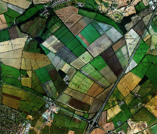
Figure 4: The circular outline of the pre-drainage ‘West Moor’ is still perceptible in boundary patterns shown on this 1999 aerial image (overlain with 1854 OS 6 inch to the mile data). The area drained by Vermuyden was probably the narrow crescent along the southern edge, now under development as the ‘West Moor Park’ commercial development.
Cities Revealed Aerial photography, 1999 © the GeoInformation Group; Historic mapping 1854 © and database right Crown Copyright and Landmark Information Group Ltd (All rights reserved 2008) Licence numbers 000394 and TP0024
The earliest reclamation of part of Thorne Moor is likely to have been in the area known as Thorne Cables, between the moor and the town of Thorne. These linear, parallel sided fields, associated with ‘moor’ placenames, are generally taken to date to the period between Vermuyden and the later parliamentary enclosures. A description of their creation survives :
“every inhabitant that had right of common and turbary in this parish, by agreement had the moor measured in breadth next to Thorne common and they computed how many yards broad would fall to each common-right house. When this was done every person had his equal breadth . . . and .. . cut to the east…; then they begun to cut drains betwixt each others moor; the turf that came out paying for the labour, and betwixt those dykes they graved their turf. . . to the very bottom… …now they have got from twenty to forty and fifty acres each of good firm land.” (Stovin c.1752)
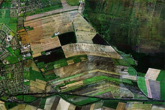
Figure 5: Thorne Cables – reclaimed from moorland by the removal of peat, by former commoners allotted land as compensation following Vermuyden’s drainage of Hatfield Chase.
Cities Revealed Aerial photography, 1999 © the GeoInformation Group; Historic mapping 1854 © and database right Crown Copyright and Landmark Information Group Ltd (All rights reserved 2008) Licence numbers 000394 and TP0024
Stovin’s description of this land improvement highlights the removal of peat, a valuable commodity that would continue to be extracted from both Thorne and Hatfield Moors until recent times. Turves were transported away from the moor by water transport during the 18th century. Boating Dyke, which cuts across many of the southern Cables, is a survival of this process.
Much of the remainder of the South Yorkshire section of Thorne Moor was allocated for enclosure by the Hatfield, Thorne, and Fishlake Enclosure Award of 1825, with the cutting of further drainage ditches in a grid pattern across the Moor (shown on Haywood 1825). However, this process does not appear to have led to a concerted effort to convert the moor to agricultural use.
Hatfield Moor appears to have avoided any direct attempts to drain it until the enactment of the 1825 enclosure award. Stovin described the moor as:
“[a] Great moras or turf more so turgid with water and so soft and rotten that it is not to be gone on unless in ye driest times of the year … good for nothing but to dig up, to dry, and burn for turves” (quoted in Dinnin 1997a).
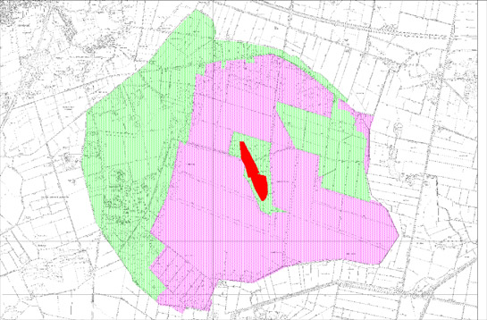
Figure 6: The extent of Hatfield Moor as enclosed in 1825: areas successfully improved by ‘dry warping’ up to 1891 shaded in green; areas marked as rough ground in 1891 shaded in purple; and Lindholme Island in red.
Historic maps © and database right Crown Copyright and Landmark Information Group Ltd (All rights reserved 2008) Licence numbers 000394 and TP0024
At the centre of the intractable waste recorded by Stovin, lay a raised area of dry land known as Lindholme Island, still apparent as an island today, standing proud of the surrounding peat. This island is likely to have been at least sporadically settled since the Neolithic; a trackway leading from it, dating to that period, was discovered in the early 21st century (Gardner 2005, 4). In the medieval period, Lindholme Island was the home of a religious hermitage (ibid, 9), but by the time Stovin visited the island in 1736 the island was in use as a farmstead, “60 acres of firm sandy ground. . .which was growing barley, oats and pease” (cited in Gardner 2005, 8).
The enclosure of Hatfield Moor is notable for the success of a technique called ‘dry warping’, through which a large band to the west and north of the moor was claimed for agriculture by the extraction of alluvium from former riverbeds of the Don and Idle and its transport overland to the moor. Both the 1825 Enclosure Award plan (Haywood 1825) and the 1851 OS 6 inch mapping of the moor indicate that it was intended that the whole area be improved in this way. However by 1894, only part of the moor had been treated in this way.
The remainder of the lands enclosed and drained by enclosure acts provide fewer indicators of their former character. Placenames tend to refer either to ‘common’ or ‘carr’. Etymologically ‘carr’ is more useful for the reconstruction of former character. Most authorities agree that ‘carr’ is derived from the Old Norse term ‘kjarr’ meaning ‘marsh’ or ‘brushwood’ (Smith 1962, 215). In South Yorkshire the word is a frequent place-name element and has been taken to refer particularly to low-lying woods bordering wet areas, with a predominance of alder and willow (Jones 2000, 53). Carr placenames in this zone are particularly concentrated to the south west of Doncaster – the ‘Doncaster Carrs’ character area highlighting their extent. This area retains the highest density of woodland of this zone.
‘Common’, the final placename element discussed here, is less indicative of former land cover, and it may simply indicate the type of land tenure in use before enclosure and drainage. Where it occurs, it may merely indicate land that was neither remembered as ‘carr’ at the time of its enclosure and first cartographic survey, nor characterised by the impenetrable vegetation of ‘moor’. Notable examples within this zone are Sutton and Norton Commons, to the east of Askern. Both these former wetlands are visible in plan form through continuous former external boundaries. Sutton Common is the better known archaeologically, for the presence of two dunes or islands of drift geology that have stood proud of the surrounding wetland for much of the Holocene (Van de Noort et al 2007, 53). Archaeological work has shown these islands acted as a locale for specialised activity in the prehistoric period. As at Lindholme, their physical isolation within wetlands seems to have been central to their use. The first identified phase of use comprised a small mortuary enclosure associated with a single pile of pyre debris dated to the early Bronze Age. The second phase included the construction, from 372BC – 350BC, of elaborate earthwork ditch and bank defences around both islands, which were broken at formal entrances, at which evidence has been found for structured deposition of human heads. Inside the defences there were later addition of what have been tentatively interpreted as ephemeral mortuary enclosures, where pyre debris was scattered following cremation (ibid, xviii).
By the mid 19th century the earlier uses of the dunes at Sutton Common were long forgotten, the Ordnance Survey plans of the 1850s marking them as Crook Hills - shortly before the Parliamentary Enclosure of the common in 1858 (English 1985, 138). This enclosure, drainage and subsequent lowering of the water table on the common appears to have had near immediate implications for the buried remains. In the 1860s timber posts likely to be related to an Iron Age causeway between the enclosures were observed, probably exposed due to the desiccation and shrinkage of protective layers of peat (Van de Noort 1997, 21).
Later Characteristics
Changes in the drained arable landscapes in this zone reflect national intensifications in agriculture, found in other enclosed historic character zones in South Yorkshire. Much of this intensification can be traced back to the drive towards national self-sufficiency in agriculture and the rise in the adoption of mechanised agricultural practice in the post-war period (Penrose 2007, 108-109). Developments typical of this period that can be identified in this zone include the conversion of traditional pasture to arable cultivation, the removal of internal hedgerow boundaries to make larger enclosures and the construction of large “functionally homogenous” (Lake 2007) shed units to replace and supplement traditional farm buildings. In Doncaster, an important development has been the intensification of drainage regimes sponsored through the 1970s and 1980s by the UK Government. At Sutton Common, further reductions in the water table are known to have been stimulated by increased intensive drainage in the 1970s, whilst in the 1980s the larger of the enclosures was flattened, the land being further improved for agriculture use by the laying of field drains.
The twentieth century also saw the conversion of some areas of drained farmland to other uses, most notably institutional functions connected with military and punitive activities. The largest military landscape in the zone was an ‘expansion period’1 heavy bomber base to the west of Hatfield Moor, within the area reclaimed by dry warping in the 19th century (SMR ref: 4344). RAF Lindholme was constructed in advance of World War II and during much of the war functioned as a training base for heavy bombers. Following World War II, the base became a training establishment for Bomber Command. It was sold in 1985 to the Prison Service, with conversion of the runways back to agricultural use; the camp to the south was reused as prison accommodation. Legible areas of the former base include the reused and converted ‘technical and domestic site’ of the airfield, within the perimeter of the current Lindholme Immigration Removal Centre. The site is complete in plan form and includes a control tower, five 'Type-C' hangars, barrack blocks (converted in 1985 from dormitory to single cell accommodation), Headquarters and officers mess buildings (interpretation based on likeness to plans of Cranfield and Feltwell, in Dobinson 2000, 137). Adjacent, but belonging to the separately described ‘Early 20th century Private Suburbs’ zone, are a number of streets of Airmen’s Married Quarters.
A late addition to the RAF station at Lindholme is the cold war period Lindholme Tactical Control Centre, one of two surviving complexes of its kind in the UK from an original four (SMR ref: 4582). The buildings, which include the base of a Type 82 Radar Unit and the Tactical Control Centre itself, served as part of the Cold War Bloodhound Missile System, a network of control centres controlling 11 missile sites, mostly protecting the bases for the British V-Force air-launched nuclear deterrent - operational until the introduction of the submarine-launched Polaris system. The Monument Protection Programme considered this site to be of “National Importance” and recommended it be put forward for listing (Cocroft 2001).
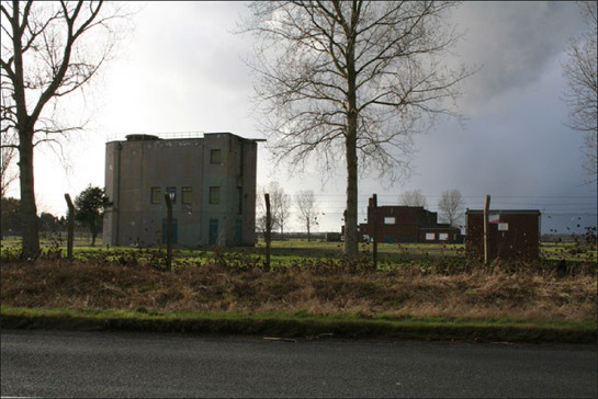
Figure 7: Lindholme Type 82 Radar Unit and Tactical Control Centre c.1950-1960
© Ken McCann and licensed for reuse under a creative commons license - http://creativecommons.org/licenses/by-sa/2.0/
The most visible and significant later landscapes in this zone relate to the large-scale extraction of peat from Thorne and Hatfield Moors, and to a lesser extent to the extraction of gravel from the western fringe of Hatfield Moor. Traditional exploitation of peat evolved into more intensive extraction in the mid 19th century, for use as horse litter. By 1903, 10,000 tonnes were extracted annually for this use from Hatfield Moor alone, although the industry declined from the 1920s onwards with the increase in motor transport. The peat industry began to dominate the moors again from 1963 onwards, when Fisons purchased the British Peat Moss Litter Company, with a consequent introduction of mechanised block cutting on both moors. During the late 1970s the introduction of the 'surface milling' technique allowed greater efficiency of operation, resulting in the eventual reduction of the peat depth on the moors to less than 2m (Van de Noort and Ellis 1997, 28-29). Following financial agreement between the UK government, English Nature and Levington's Horticulture (successor in title to Fisons), most peat cutting at Hatfield ceased in 2004 - the site, now in the ownership of Natural England, is to be managed for public access and conservation as a National Nature Reserve.
Character Areas within this Zone
Map links will open in a new window.
- Bentley Ings to Thorne Don Valley (Map)
- Doncaster Carrs (Map)
- Don Gorge Valley Floor (Map)
- Humberhead Drained Farmland (Map)
- Sutton / Norton Commons and Wrancarr (Map)
- Thorne and Hatfield Moors (Map)
- Went Ings (Map)
Bibliography
- Cocroft, W.D.
- 2001 Cold Mar Monuments: an assessment by the Monuments Protection Programme [unpublished]. English Heritage.
- Dinnin, M.
- 1997a The Drainage History of the Humberhead Levels. In: R. Van de Noort and S. Ellis (eds.), Wetland Heritage of the Humberhead Levels. Hull: Humber Wetlands Project/ University of Hull.
- Dinnin, M.
- 1997b The Paleoenvironmental survey of West, Thorne and Hatfield Moors. In: R. Van de Noort and S. Ellis (eds.), Wetland Heritage of the Humberhead Levels. Hull: Humber Wetlands Project/ University of Hull.
- Dobinson, C.S.
- 2000 Twentieth Century Fortifications in England: Volume IX, Airfield Themes. York: Council for British Archaeology.
- English, B.
- 1985 Yorkshire Enclosure Awards. Hull: Department of Adult Education, University of Hull.
- Gardner, R.
- 2005 Lindholme Hall, Hatfield Woodhouse, South Yorkshire [unpublished]. Archaeological Desk Based Assessment. Pre-Construct Archaeology Lincoln. DONMG:2005.35
- Haywood, J.
- 1825 Hatfield, Thorne, Fishlake, Stainforth and Sykehouse Enclosure Award Plan. [unpublished microfilm copy of original 12 chains to the inch plan held by Doncaster Archives] Sheffield Archives reference A152/3
- Hopkinson, G.G.
- 1956 The Development of Inland Navigation in South Yorkshire and North Derbyshire, 1697-1850. Transactions of the Hunter Society, Vol VII, 5, 229-251.
- Jones, M.
- 2000 The Making of the South Yorkshire Landscape. Barnsley: Wharncliffe Books.
- Lake, J.
- 2007 Farming., paper presented at Characterising Modern Times EH biennial characterisation seminar, Society of Antiquaries London, 7th December 2007.
- Miller, K.
- 1997 The Isle of Axholme Historic Landscape Characterisation Project [unpublished]. Countryside Commission.
- Hey, D.
- 1979 The Making of South Yorkshire. Ashbourne: Moorland Publishing Company.
- Holland, D.
- 1980 Changing Landscapes in South Yorkshire. Doncaster: D.Holland.
- Page, W., Proby, G. and Ladds, S.I.
- 1936 'The Middle Level of the Fens and its reclamation', A History of the County of Huntingdon: Volume 3 (1936), 249-290.
Available from: http://www.british-history.ac.uk/report.aspx?compid=66187.
[accessed 17/12/07]. - Penrose, S.
- 2007 Images of Change: an Archaeology of England’s Contemporary Landscape. London: English Heritage.
- Rackham, O.
- 1986 The History of the Countryside. London: Dent.
- Smith, A.H.
- 1962 The Place-Names of the West Riding of Yorkshire: Part VII. Cambridge: Cambridge University Press.
- Stovin, G.
- 1752 Hatfield Chase: A brief account of the Drainage of the Level of Hatfield Chase in the Countys of York, Lincoln and Nottingham with the Country Adjacent. Transcription by F. Dickinson from original document held by West Yorkshire Archives.
Available from: http:/members.aol.com/fdickinson/stovin.htm [accessed 18/12/07]. - Van de Noort, R., Chapman, H.P, Collis, J.R.
- 2007 Sutton Common: The excavation of an Iron Age ‘marsh-fort’. CBA research report 154, York: Council for British Archaeology.
- Van de Noort, R. and Ellis, S. (eds.)
- 1997 Wetland Heritage of the Humberhead Levels. Hull: Humber Wetlands Project / University of Hull.
1The RAF’s ‘expansion period’ dates to 1934-1939 and the Expansion Schemes A-M, which sought to rapidly expand UK air capabilities following the withdrawal of Germany from the League of Nations Disarmament Conference in Geneva (Dobinson 2000, 73-119)