Late 20th Century Municipal Suburbs
Summary of Dominant Character
This zone represents suburban areas built by municipal authorities since 1960. There is often significant divergence between the plan forms of municipal and private developments built during this period, with municipal housing developments showing a shift in emphasis during this period from enclosed private gardens to unenclosed communal spaces. This move away from ‘garden suburb’ styles is accompanied by the increasing segregation of pedestrian routes from road systems. Building densities are noticeably higher than in the ‘Early to Mid 20th Century Municipal Suburbs’ zone.
Municipal estates within this zone are often based on the ‘Radburn’ principles of design. These principles originating in a study by US architects Stein and Wright of English ‘garden suburb’ planning (Sheffield Corporation 1962, 12) and aimed to maximise the separation of vehicles and pedestrians by avoiding points at which pedestrians would have to cross roads. Instead of facing on to carriageways, houses were designed to front directly onto common green spaces without privately demarcated enclosed gardens.
The ‘Radburn’ estates built across this zone in this period are typical of many developed nationwide from the 1950s through to the late 1970s and are generally constructed according to ‘system building’ techniques, such as the ‘No Fines’ method developed by Wimpey. Houses built in this system were cast in-situ from a concrete mix requiring no ‘fine’ aggregates (i.e. cement and gravel). This method could be executed quickly and cheaply – however the resulting aesthetics of the properties, which were finished with quickly applied render, are generally regarded as bleak. Structural problems with the system include poor thermal insulation and condensation.
More recent urban design theories (Doncaster MBC undated d, 18) have turned away from the open plans of these areas, which is now believed to offer no ‘defensible space’ to residents, the common parking areas provided to the rear of property have also been criticised as “poorly overlooked and magnets for anti-social behaviour” (CSR Partnership 2004, 26). South Yorkshire’s ‘Housing Market Renewal’ programme has made the ‘de-Radburnisation’ of some of these areas a specific target of a number of its masterplans (Jones 1999; Chan 2007).
The vast majority (81%) of the land in this zone has a residential character. The next most extensive land use (11%) is by institutional complexes, mostly Doncaster MBC primary and secondary schools and their playing fields that are contemporary with the surrounding estates. Schools built during this period were generally constructed using building systems such as those developed by the public sector CLASP [Consortium of Local Authorities Special Project] group. Buildings constructed using the CLASP system (in common with private sector systems such as Vic Hallam’s ‘Derwent system’) feature significant amounts of prefabricated materials and are generally formed from prefabricated steel frames infilled with asbestos, wood or concrete panels under flat roofs. The system was regarded as being particularly suitable for construction on sites liable to mining subsidence (CLASP undated). Developments at other municipal and government sites in this zone also show strong influences of the system building movement.
Public recreational space, where provided in this zone (c.5% of overall area), generally consist of recreation grounds rather than the more ornamental parks common to earlier periods. No woodland areas, either ‘ancient’ or ‘plantation’, large enough to have been characterised as units in their own right are included within this zone.
Relationships to Adjacent Character Zones
This zone is almost always directly adjacent to earlier suburbanisation recorded in the ‘Early to Mid 20th Century Municipal Suburbs’ zone. This reflects a continuing 20th century trend towards the expansion of suburban landscapes.
As one of the most recent phase of suburbanisation, most character areas within this zone are to be found between an area of older suburbanisation and areas of rural countryside that exhibits various patterns of enclosure.
Inherited Character
This zone includes a small number of surviving character units that predate the main period of suburbanisation. Of these character units, those classified with a Broad Type of ‘Enclosed Land’ are rare – an example includes a small area of post-medieval piecemeal enclosure, totalling only 4.7ha, adjacent to York Road in Scawthorpe.
The majority of the pre-1960 character units within this zone are recreation grounds, allotments, schools and cemeteries originally developed on the fringes of earlier phases of suburbanisation (in the late 19th-early 20th centuries). These have continued to be used by residents of later suburbs.
88% of the land developed in this area since 1960 (mostly for homes, schools and playing fields) has been recorded as having had a previously ‘enclosed’ character. The legibility of this previous character has generally been assessed by the project as ‘invisible’, although - as with other suburban areas - earlier roads passing through these developments have generally been retained, as have boundaries on the edges of development phases, where earlier land parcels formed the unit of development.
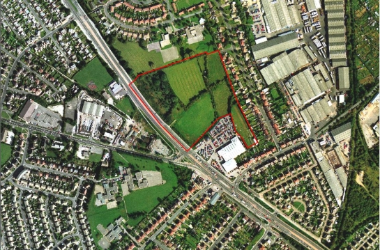
Figure 1: Within the ‘Scawsby / Scawthorpe Post-1960 Municipal’ character area is a small piece of relict enclosure countryside, now surrounded on all sides by 20th century suburbanisation (character unit HSY5157).
© 1999 Cities Revealed / GeoInformation Group
Later Characteristics
The main period of historic character in this zone stretches from the 1960s to the time of the current project and as a result its dominant characteristics are continuing to form.
Character Areas within this zone
Map links will open in a new window.
- Balby Bridge Estate Doncaster (Map)
- Mexborough Post-1960 Municipal Suburbs (Map)
- Scawsby / Scawthorpe post 1960 suburban (Map)
- Thorne Municipal Suburbs (later) (Map)
Bibliography
- GBHGIS (Great Britain Historical GIS Project)
- 2008 Doncaster: Population Rate through time. In: A Vision of Britain Through Time [online]. Leeds and Bristol: Universities of Portsmouth. Available from: www.visionofbritain.org.uk/data_rate_page.jsp?u_id=10202607&c_id=1000104... [accessed 8/08/08].
- Chan, S.
- 2007 Doncaster Housing Market Renewal (HMR) Pathfinder Programme – Masterplans for Woodlands Way Neighbourhood, Denaby Main and Associated Programme [unpublished]. Report of Housing Strategic Initiatives Manager to Mayor and Members of Cabinet, Doncaster MBC. Available from: www.doncaster.gov.uk/about/chamber/.%5CReports%5C031007Cabr4.doc [accessed 8/08/08].
- CLASP
- undated CLASP Consortium [online]. Available from: www.clasp.gov.uk/NetBuildPro/process/6/History.html [accessed 8/08/08].
- CSR Partnership
- 2004 Masterplanning at Royal: Granby: Howbeck Estates, Edlington. CSR Partnership for Doncaster MBC / Transform South Yorkshire Available from: www.doncaster-community.co.uk/Living_in_Doncaster/Homes_and_Housing/HMR_pathfinder/edlington/Masterplans_for_Edlington.asp [accessed 8/08/08].
- Doncaster MBC
- [undated] Landscape Planning on Development Sites in Doncaster: Consulation Draft. Doncaster: Doncaster MBC Environment and Planning Services.
- Jones, M.
- 1999 Denaby Main: The Development of a South Yorkshire Mining Village. In: B. Elliot (ed.), Aspects of Doncaster 2: Discovering Local History. Barnsley: Wharncliffe Books, 123-142.
- Sheffield Corporation
- 1962 Ten Years of Housing in Sheffield. Sheffield: Sheffield Corporation: Housing Development Committee.