Strip Enclosure Zone
Summary of Dominant Character
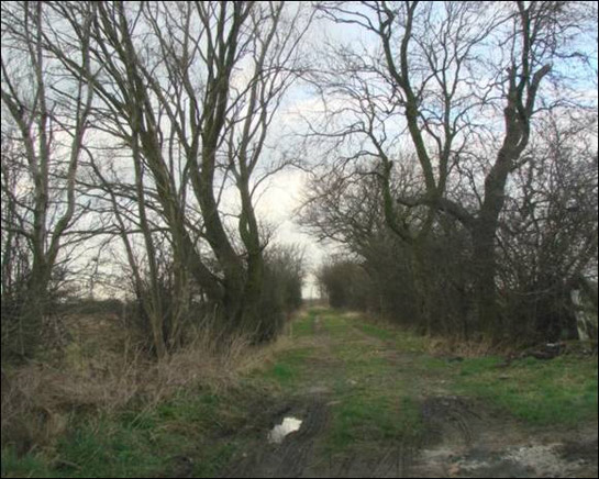
Figure 1: Un-metalled ‘green-lanes’ are still common in the ‘Fosterhouses Strip Enclosure’ character area. This example is in an area that was probably enclosed piecemeal from Fishlake West Field before the 1825 Parliamentary Award.
Photo © 2007 Bill Henderson licensed for reuse according to a creative commons license – http://creativecommons.org/licenses/by-sa/2.0/
This zone is typified by semi regular to irregular patterns of small to medium enclosures, generally bounded with dense species rich hedgerows with frequent mature trees (Doncaster MBC 2006). Such characteristics are generally considered an excellent indicator that the hedgerows are of pre-parliamentary enclosure origin (Rackham 1986, 194-204; Pollard et al 1974).
Field patterns in this zone vary from arrangements of intersecting blocks of curving narrow rectilinear fields, forming semi regular strip patterns, through to less regular patterns more characteristic of landscapes assarted from woodland over a long period. These patterns are clearest in areas where land is managed as permanent pasture but there are also parts of the zone in which more intensive arable cultivation is being practised. In these intensified areas the field patterns are larger in scale and generally less densely hedged.
Where land is still maintained as pasture, the highest concentrations of upstanding ridge and furrow and of moated site earthworks, in South Yorkshire, can be found.
Road patterns in this area are typically sinuous or irregular, with some un-metalled ‘green lanes’ forming significant features, particularly around Fishlake and Sykehouse. Parish boundaries and road boundaries generally feature mature species rich hedgerows.
In contrast to the road network are a number of straight linear routes related to main and branch railway lines and to the New Junction Canal. These features overlie the earlier field and road patterns, bisecting fields and other features.
Settlement within this zone, which surrounds a number of significant ‘Nucleated Rural Settlements’, includes a significant number of dispersed farmsteads; 25 listed farm buildings dating from the 17th to 19th centuries are recorded here (English Heritage 2005). The dispersed farmsteads in this landscape typically evolved from simple linear, l-plan and dispersed layouts into more formal courtyard arrangements in the later 19th century (see Lake and Edwards 2006, 42-44 for a detailed account of farmstead plan-form types). Building materials used for older structures are predominantly brick and tile, although sandstone rubble is sometimes seen in lower building courses. Many farms feature significant post 1950 expansion phases in the form of large prefabricated metal barns used predominantly for cattle shelter.
Blocks of woodland in this zone are less common and smaller in size than in other assarted or strip enclosure landscapes in South Yorkshire, probably as a result of a lack of steep slopes in this generally low relief landscape. Where they do exist, they are rarely large enough to have been recorded in the project database in their own right.
Relationships with Adjacent Character Zones
This character zone is closely related to its underlying geological strata, which can be generalised as an area of Bunter Sandstone overlain with silts, clays and gravels. To the east and west of the zone, the Bunter Sandstone is overlain by areas of alluvium that were historically less suitable for settlement and arable production. This change in geological character is marked by changes in historic characteristics described in the ‘Wetland Enclosure’ and ‘Surveyed Enclosure’ character zone descriptions.
To the south of Fenwick, around the area of Moss, there is a substantial area of former common belonging to the ‘Surveyed Enclosure’ zone.
To the north and south of the zone are the floodplains of the Went and Don rivers respectively. In these areas land use was historically characterised by seasonally flooded grassland meadows (known locally as ‘ings’), which is described in the ‘Wetland Enclosure’ character zone. The villages of Sykehouse, Fishlake, Fenwick, Haywood, Braithwaite and Thorpe in Balne all relate to this character zone but collectively form a part of the ‘Nucleated Rural Settlements’ zone.
Inherited Character
The principal character of this zone relates to non surveyed or piecemeal patterns of land enclosure. The patterns visible on 19th century mapping throughout this zone suggest that much of the enclosed land at that time had developed from large open field systems surrounding nucleated villages - a pattern typical of much of the English midlands (see Hall 2001, 13-15). The characterisation project defines ‘Strip Enclosure’ as “Fields resulting from the enclosure of medieval open fields. Typically these fields are at least 5 times longer than their width with essentially parallel sides exhibiting reverse-s curve boundaries fossilising the shape of earlier cultivation strips within the common field” (SYAS 2005). This type of enclosure pattern is generally thought to have resulted from the private enclosure of common arable fields from the late medieval period onwards (Taylor 1975, 78-80).
Map evidence examined during this project indicates that in South Yorkshire the majority of this type of enclosure predated the first 6 inch to the mile survey by the Ordnance Survey in the mid 19th century, with very few new examples appearing in the later 19th and early 20th centuries. Good examples of strip enclosure patterns of this type can be seen: to the south of Sykehouse (character unit HSY4384); to the south of Thorpe in Balne (character HSY4332); and to the east (character HSY4392) and north (character HSY87) of Fenwick and in the ‘Fosterhouses Strip Enclosures’ character area north east of Fishlake. The area of strip fields at Fosterhouses were already enclosed by 1825, when the Hatfield Thorne, Fishlake, Stainforth and Sykehouse enclosure award was drawn up (Haywood 1825). Late 18th century legal papers (Sheffield Archives references DDCL/1808 and CM/1373) refer to the area as “closes in the Hays of Fishlake” - part of this area is still known as Hayes, a placename that may mean “enclosure” (Smith 1964, 15) or, more specifically, “land enclosed by hedges” (Field 1972, 101). This suggests that these piecemeal strip enclosures may be medieval in origin, as the placename Hayes has been traced to 1343 [written as Haya] and 1404 [written as le Haghe] in documents relating to this location (Smith 1964, 15).
Ridge and furrow is recorded by the characterisation database and the South Yorkshire Sites and Monument Record in 14 character units within this zone, although detailed field survey would undoubtedly reveal further sites.
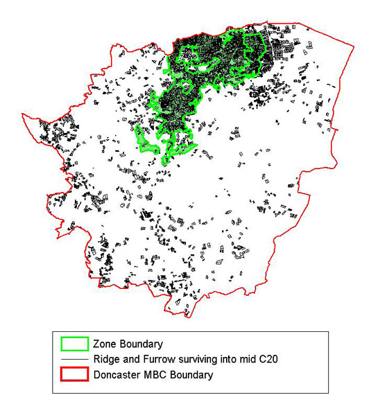
Figure 2: A significant proportion of the ‘ridge and furrow’ earthworks surviving into modern times in Doncaster were within this zone.
Aerial survey data based on Roberts et al 2007 © 2007 EH
Comprehensive digitisation of archaeological features apparent on 20th century aerial photographs (English Heritage 2007; Roberts et al 2007) showed a particular concentration of ridge and furrow surviving until at least the mid 20th century that almost exactly corresponds to this character zone. The majority of this ridge and furrow is interpreted as being of post-medieval origin. The fossilisation of these ridge and furrow patterns is likely to have taken place at a time when land passed from arable use to permanent pasture; continued management as grassland has prevented the earthworks from being ploughed away (Fairclough 2001, 11).
The loss of ridge and furrow in this zone, particularly along its western fringe, is intimately related to the reintroduction of arable farming and consequent intensification of land use through the removal of field boundaries in the late 20th century (discussed below).
The piecemeal nature of the enclosure of this zone means that many of the patterns and features of earlier landscapes survive. Many lanes and some longer continuous boundaries, for example those that enclosed the earlier open field units and marked the edges of parishes, may well have been established in the medieval period. Definite legibility of medieval landscape features is provided by the surviving moated sites. In a national context these earthwork sites are generally agreed to consist of a: “wide, water-filled ditch partly or completely enclosing one or more islands of dry ground which provided the site for one or more buildings (domestic, religious or agricultural), or for horticulture, or for both” (Darvill 1988, Para. 1).
These features frequently served to emphasise the high status of a residence, often a manor. Moated sites are sometimes known in association with other earthworks, such as building platforms, causeways or fishponds (ibid, Para 7). They are often found sited on low lying land.
Of the twenty-three moated sites recorded on the South Yorkshire SMR (SYAS 2008) in the Doncaster MBC area, eleven are within this zone. Most of these have survived due in no small measure to their identification and cataloguing as archaeological sites (see Le Patourel 1971; and Roberts 1977, 91-94 for lists of sites), with most gaining legal protection as Scheduled Ancient Monuments during the later 20th century (English Heritage 2004c). The importance of this level of legal protection is best highlighted by the case of the unscheduled Woodhouse Field Moat [SMR ref: 315], photographed and described as an upstanding monument in 1980. Site notes, dated January 1986, record the deliberate levelling of the field in which the monument stood through the infilling of the moat with imported soil and drainage with land drains prior to cultivation (Sydes 1986). The damage to the site and the surrounding former ridge and furrow patterns is clearly visible on 1999 vertical aerial photography, with the site visible as soil marks, a clear sign that the most recent ploughing of this land has disturbed the stratigraphic layers making up this monument.
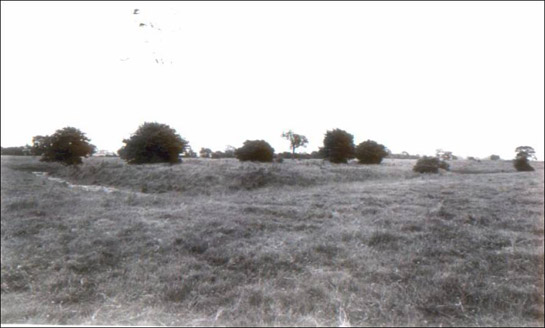
Figure 3: Woodhouse Field Moat from the North West, July 1980.
By P.F.Ryder © SYAS
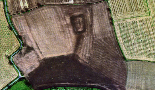
Figure 4: Woodhouse field moat in 1999 (dark rectangle at top middle of frame). Ridge and furrow patterns and the dark outline of the moat are now visible as soil marks in this recently ploughed field.
Cities Revealed aerial photography © the GeoInformation Group, 1999.
Better preserved examples include Thorpe in Balne Manor House (SMR ref: 309); Fenwick Hall (SMR ref:312); Radcliffe Moat (SMR ref:393); Tilts Farm (SMR ref:399); and Round About Moat (SMR ref:399). Of these, the most dramatic is Thorpe in Balne Manor House, a site with a well preserved medieval moat, building platform, fishponds and an upstanding section of medieval chapel retained in a later complex of barns. The residential complex at the site was rebuilt in the 18th, 19th and 20th centuries. A further well preserved complex can be seen at Radcliffe Moat near Adwick-le-Street, where a medieval moated site is preserved in a small area of rough ground that also includes a rare example of a waterlogged Motte and Bailey castle and the possible earthwork remains of Langthwaite or Hangthwaite deserted medieval village (Beresford 1953, 239).
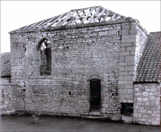
Figure 5: Fragment of chapel wall retained in later barns at the site of Thorpe in Balne Manor House, June 1981.
By P.F.Ryder © SYAS
Later Characteristics
An important factor in the later development of the historic character of this zone has been the intensification of drainage regimes sponsored through the 1970s and 1980s by the UK Government Ministry of Agriculture. This intensification often led to the agglomeration of fields, a process that in this zone occurs later than in other parts of South Yorkshire, frequently not becoming apparent until 1980s and 1990s mapping. The effects of this state sponsored drainage programme has been studied in detail at Sutton Common, to the immediate west of this zone, where one phase is known to have reduced water levels by 2m (Van de Noort et al 2007, 7), greatly increasing the viability of arable exploitation in the area. It is probable that it was one of these drainage schemes that resulted in the damage to Woodhouse Field Moat (described above). Damage through the desiccation of previously waterlogged remains has been highlighted as potentially important in many of the scheduling descriptions for the moated sites within Doncaster.
The introduction of arable farming within this zone is apparent when comparing some of the many aerial photographs taken by Derrick Riley, over the 1970s and 1980s1, with vertical photos taken in the late 1990s. The loss of large areas of ridge and furrow can be seen during this period. Analysis of aerial photography has indicated that “only one fifth [of previously recorded ridge and furrow] appears to be extant on the most recent air photographs and this is largely concentrated in the area between the rivers Went and Don and the ancient settlements of Sykehouse and Fishlake” (Roberts et al 2007, Chapter 8, p4).
The process of agricultural intensification has continued into the present, as the economies of scale provided to farmers by larger land parcels continue to offer incentives to remove hedges. Acting to counter this trend are incentives offered by the ‘stewardship’ schemes brought in by central government since the early 1990s. These schemes offer financial incentives to farmers who enter into environmental management agreements, which can include steps to maintain or restore historic features such as boundaries, buildings and (under the Environmental Stewardship system in place since 2005) and reduce the impact of activities on known buried archaeological sites (Rural Development Service 2005, 68-70).
A contemporary development has been the introduction of the Hedgerow Regulations of 1997 (HMSO), which require notification of the Local Planning Authority before the removal of a hedgerow - in addition to conferring powers on the same authority to serve a Hedgerow Retention Notice where hedgerows can be defined as important in historical, archaeological, wildlife or landscape terms.
Character Areas within this Zone
Map links will open in a new window.
Bibliography
- Beresford, M.W.
- 1953 The Lost Villages of Yorkshire. Yorkshire Archaeological Journal 150, 215-240.
- Darvill, T.C.
- 1988 Monuments Protection Programme. Monument Class Description: Moats fifth revision [online]. London: English Heritage. Available from: http://www.eng-h.gov.uk/mpp/mcd/moat.htm [accessed 9/02/08]
- Doncaster Metropolitan Borough Council (DMBC)
- 2006 Doncaster Hedgerow Survey [unpublished GIS data set]. Available from: Doncaster MBC Landscape Planning - Environment Group, Planning Services, Danum House, Doncaster, DN1 1UB.
- English Heritage
- 2004 Scheduled Monument System Data [unpublished dataset export]. Swindon: English Heritage National Monuments Record. Available from: National Monuments Record Centre, Kemble Drive, Swindon.
- English Heritage
- 2005 Listed Building System Data [unpublished MIDAS dataset export in xml format]. Swindon: English Heritage National Monuments Record. Available from: National Monuments Record Centre, Kemble Drive, Swindon.
- English Heritage
- 2007 Archaeological Cropmarks of the Magnesian Limestone [unpublished GIS data set]. Swindon: English Heritage National Monuments Record. Available from: National Monuments Record, Kemble Drive, Swindon.
- Fairclough, G.
- 2001 Foreword – Strategies for understanding and protection. In: D. Hall, Turning the Plough: Midland open fields: Landscape Character and Proposals for Management. Northampton: Northamptonshire County Council / English Heritage, 9-12.
- Field, J.
- 1972 English Field Names: A Dictionary. Newton Abbot: David and Charles (Publishers) Ltd.
- HMSO
- 1997 The Hedgerows Regulation (Statutory Instrument 1997 No.1160)
- Hall, D.
- 2001 Turning the Plough. Midland Open Fields: Landscape Character and Proposals for Management. Northampton: Northamptonshire County Council and English Heritage.
- Haywood, J.
- 1825 Hatfield Thorne, Fishlake, Stainforth and Sykehouse Enclosure Award Plan. [unpublished microfilm copy of original 12 chains to the inch plan held by Doncaster Archives] Sheffield Archives reference A152/3
- Le Patourel, H.E.
- 1971 The Moated Sites of Yorkshire. London: Society for Medieval Archaeology
- Lake, J and Edwards, B
- 2006 Historic Farmsteads. Preliminary Character Statement: Yorkshire and Humber Region. Cheltenham: University of Gloucester Countryside and Community Research Unit / English Heritage / Countryside Agency.
- Pollard, E., Hooper, M.D. and Moore, N.W.
- 1974 Hedges. London: Collins
- Rackham, O.
- 1986 The History of the Countryside. London: J.M. Dent
- Roberts, P.
- 1977 Moated Sites of the Doncaster District. In: J.R. Magilton, 1977 The Doncaster District: An Archaeological Survey. Doncaster: DMBC Museum and Arts Service, 91-93.
- Roberts, I., Deegan, A., Berg, D. and Ford, L.
- 2007 Archaeological Cropmark Landscapes of the Magnesian Limestone. [Unpublished project report]. Morley: Archaeological Services WYAS for English Heritage.
- Rural Development Service
- Higher Level Stewardship.
- Smith, A.H.
- 1961 The Place-Names of the West Riding of Yorkshire- Part One. Cambridge: Cambridge University Press.
- SYAS
- 2005 South Yorkshire Historic Environment Characterisation: revised project design 18th Feb, 2005. [Unpublished document]. South Yorkshire Archaeology Service.
- SYAS
- 2008 South Yorkshire Sites and Monument Record [dynamic MS Access – GIS database] Sheffield, South Yorkshire Archaeology Service. Available by appointment with SYAS, Howden House, 1 Union Street, Sheffield, S1 2SH. Email: syorks.archservice@sheffield.gov.uk [accessed 9/01/08]
- Sydes, B.
- 1986 Site Visit: Woodhouse Field Moated Site, PI315. [unpublished site visit note in SY SMR file 315] Available by appointment with SYAS, Howden House, 1 Union Street, Sheffield, S1 2SH. Email: syorks.archservice@sheffield.gov.uk
- Taylor, C.
- 1975 Fields in the English Landscape. London: J.M Dent
- Van de Noort, R., Chapman, H.P. and Collis, J.R.
- 2007 Sutton Common: The excavation of an Iron Age ‘marsh-fort’. CBA research report 154. York: Council for British Archaeology.
1A selection of these photographs relating to South Yorkshire has been indexed by 1km grid square and is available for consultation by appointment with the SYAS SMR officer at Howden House, 1 Union Street, Sheffield.