Industrial Zone
Summary of Dominant Character
This zone comprises the major areas of traditional heavy industry in Doncaster borough still active in 2003. The zone excludes mineral extraction (see ‘Extractive Zone’) and those large-scale landscapes characterised by the construction of leisure, retail and light industrial activity on former sites of heavy industry (see ‘Post Industrial’ zone).
The built landscape of this zone is characterised by large factory buildings, mostly dating to the mid 20th century and generally constructed from prefabricated materials such as steel and concrete, although pre-1919 examples featuring brick walling with steel truss roofing can be found. Massive shed like factories are the dominant built form, although most are surrounded by smaller ancillary buildings and offices. Buildings are set in generally flat, open landscapes. Open spaces in the zone are either open railway yards, characterised by multiple sidings interspersed with scrub, or they are tarmaced areas used for car parking or the distribution or storage of raw materials and finished products. Road patterns are straight and regular, especially in the ‘Balby Bank’ character area.
The industries represented include locomotive & carriage manufacture, engineering and repair [Doncaster Plant Works est.1953 (Bayliss 1995, 40)]; agricultural machinery manufacture [Doncaster Works, International Harvester later Case, Wheatley Hall Lane est. 1939]; glass working [Pilkingtons, Kirk and Long Sandall est.1930 (Ashurst 1992,127)]; synthetic fibre manufacture [British Bemberg later ICI and DuPont, Wheatley Hall Road est.1929 (Bayliss 1995,55)] in striking modernist factory and office buildings by important architects Wallis Gilbert and Partners (Skinner 1997, 233-234); and sundry smaller concerns.
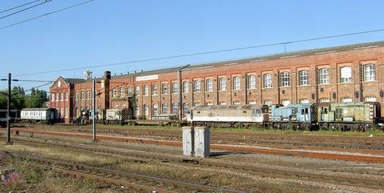
Figure 1: Doncaster Plant Works from Doncaster Station.
© 2007 Steve Fareham and licensed for reuse with a creative commons licence. http://creativecommons.org/licenses/by-sa/2.0/
Relationships with Adjacent Character Zones
The most important relationship between this zone and those that surround it is with the large areas of housing built to accommodate the industrial workforce. In Kirk Sandall, where several thousand employees worked for a single employer (Davis and Morley 2006, 400-401), housing was provided on land owned by the Pilkington company, who developed an entire model village community designed by influential planner Patrick Abercrombie (see ‘Planned Industrial Settlements’). The growth of this zone also took place alongside the growth of terraced housing in the ‘Wheatley’, ‘Bentley Rise’, ‘Balby’, and ‘Hexthorpe’ character areas (see ‘Grid Iron Terraced Housing’ zone), as well as suburban housing expansion belonging to the ‘Early to Mid 20th Century Suburbs’ character zones. Later suburban development is harder to associate with particular industrial areas because of the rise of individual mobility in the later 20th century, encouraged by greater car ownership.
Inherited Character
As with the industrial zones of Sheffield, Barnsley and Rotherham, this zone occupies a largely riverine location. However, the location of Doncaster’s heavy industries zone was not influenced by the presence of early water powered predecessors or by the transport opportunities offered by the South Yorkshire Navigation. It grew up in this position to take advantage of the flat wide open space of the valley floor, close to the railway line that was itself positioned along the level topography of the valley floor.
The pre-industrial character of the Doncaster character areas was largely rural, with 1850s OS mapping indicating ‘ing’ meadows alongside the river Don. Ings are generally understood to be low lying riverside land, prone to flooding and used for the provision of winter feed for animals during the months when pasture grasslands (kept for grazing) were less productive (Rackham 1986, 332). At the edges of the alluvial flood plain, the 19th century landscape was characterised by the strip enclosure patterns commonly associated with land enclosed piecemeal from open fields. Very little legibility survives in this zone of either of these landscapes.
A different pattern dominated the ‘Balby Bank’ character area, where the current landscape pattern is still influenced by the regular geometric surveyed enclosure patterns of the ‘Hexthorpe with Balby and Long Sandall’ enclosure award of 1785 (date from English 1985, 69). Here the present alignment of factory buildings is set perpendicular to the main arterial road that bisects the area. This road, Balby Bank Road, dates to the enclosure award and is of typical enclosure period form. The positioning of the factories echoes the earlier pattern of the enclosures.
The earliest industrial development within this zone was the town Gas Works built in a meander of the river Don just north of the town centre some time prior to 1851. The original site lay to the west of the present gasholders (first depicted by the Ordnance Survey in 1894) and was demolished between 1972 and 1984. By 1948 industrial development in this area was still small, occupying between 5-10 hectares. Reused early 20th century industrial buildings survive from this phase around the junction between Mile Thorne Lane and Wharf Road and include a spinning mill, toffee factory and wallpaper factory.
The earliest phases of Doncaster Plant Works include the long office block that can be seen from the platforms at Doncaster Station and the machine shops that lie to its immediate west. The plant was enlarged in 1890 with a new larger erecting shop (Bayliss 1995, 40). The earliest developments in the Balby Carr Bank character area also related to the railway, with early phases of the Carr Wagon Works surviving at SE585010 (ibid). Contemporary with the growth of the adjacent railway yards was the development of a substantial wire works to the east of Catherine Avenue, producing wire rope for the collieries of the region. Much of the early phases of this complex survive within the present Carr Hill works of Bridon (formerly British Ropes).
Beyond the legibility of the surveyed enclosure of Balby Carr described above the vast majority of character units within this zone have no legibility of earlier character types.
Later Characteristics
As with the areas of heavy industrial character in Sheffield, Rotherham and Barnsley, the general character trajectory of much of this zone seems likely to move towards a ‘Post Industrial’ phase in the future. This trend is already visible in the newer developments to the south of Carr Road and Wheatley Hall Road, where the greater importance of retail and distribution industries is already becoming apparent. Significant areas of Pilkington’s Glass factories at Kirk / Long Sandall have been decommissioned in the past two decades, as has the former British Bemberg facility on Wheatley Hall Road – its closure announced by owners DuPont in 1996 (New York Times 1996).
Character Areas within this Zone
Map links will open in a new window.
Bibliography
- Ashurst, D.
- 1992 The History of South Yorkshire Glass. Sheffield: J.R.Collis Publications.
- Bayliss, D.
- 1995 A Guide to the Industrial History of South Yorkshire. Sheffield: Association for Industrial Archaeology.
- Davis, S. and Morley, B.
- 2006 County Borough Election in England and Wales 1919-1938 Volume 3: A comparative analysis. Ashgate Publishing Ltd.
- English, B.
- 1985 Yorkshire Enclosure Awards. Hull, University of Hull Department of Adult Education.
- New York Times
- 1996 DuPont to Cut 2,800 Jobs in Nylon Revamping. 15th November, 1996. Available from: http://query.nytimes.com/gst/fullpage.html?res=9A0DEFDD173AF936A25752C1A... [accessed 10/01/2008].
- Skinner, J.S.
- 1997 Form and Fancy: Factories and Factory Buildings by Wallis, Gilbert and Partners, 1916-1939. Liverpool: Liverpool University Press.