Agglomerated Enclosure Zone
Summary of Dominant Character
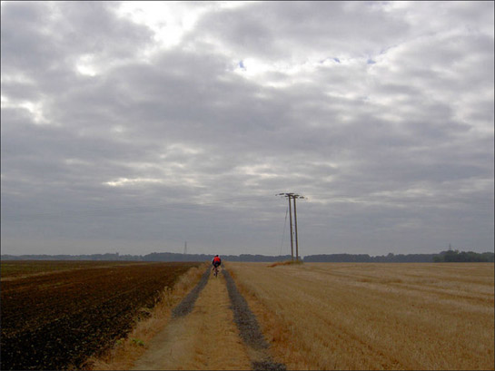
Figure 1: This zone is typified by enormous arable fields with few boundaries.
Photo ‘Is it going to Rain?’ taken near Barnburgh and is © Steve Fareham 2007 and licensed for reuse under a creative commons license http://creativecommons.org/licenses/by-sa/2.0/
The ‘Agglomerated Enclosure’ zone dominates much of the open countryside of the Magnesian Limestone and Coal Measures Sandstone geological areas of Doncaster borough. Intensification in arable farming technologies is immediately apparent in this predominantly enclosed landscape1, with enormous land parcels and with very few hedgerow boundaries to be found. As a result of this boundary loss, 55% of the ‘Enclosed Land’ of this zone has been recorded within the project database as ‘Agglomerated Fields’. Despite this, closer examination of the landscape of this zone reveals a deeper history - an agricultural landscape planned in the medieval period or earlier and based on the medieval common arable system.
The zone also contains the majority of the surviving ancient woodlands in Doncaster. Pre-20th century farm buildings in this zone typically feature limestone walling and red clay tile roofing, however, from the mid twentieth century onwards many have been augmented by large prefabricated metal shed-type barns.
Relationships with Adjacent Character Zones
The landscapes of this zone alternate with landscapes of the ‘Surveyed Enclosure’ zone. Distinctions between the two zones can be subtle and difficult to identify on the ground, with both types having seen twentieth century agricultural intensification.
Scattered throughout these two zones, and historically related to the common field heritage underlying both, are a number of villages from the ‘Nucleated Rural Settlement’ zone.
The agricultural productivity of the soils within this zone has historically facilitated the accumulation of large agricultural surpluses. From the 17th to 19th centuries this wealth was displayed through the establishment of large landscaped parklands. Elements of the ‘Private Parklands’ zone can be found adjacent to this zone at Brodsworth, Owston, Hickleton, and High Melton.
In the 20th century the underlying limestone bedrock and coal seams of the zone were intensively exploited, and significant landscapes of the ‘Extractive’ zone exist in close proximity to this zone – sometimes as islands within it.
Inherited Character
The principal legibility of this zone consists of those underlying elements relating to non-surveyed or piecemeal patterns of land enclosure, principally that of former ‘Strip Enclosure’. The main evidence comes from road patterns exhibiting the characteristic sinuous curves of former open fields, although some curving field boundaries also preserve this former character.
Well preserved strip enclosure landscapes survive within this zone adjacent to the villages of Clayton, Hooton Pagnell, Braithwell, Micklebring and Clifton. The patterns visible on 19th century mapping throughout this zone suggest that most of the enclosed land at that time had developed from large open fields surrounding nucleated villages, in a pattern typical of much of the English Midlands (see Hall 2001, 13-15). This type of enclosure pattern is generally thought to have resulted from the private enclosure of common arable fields from the late medieval period onwards (Taylor 1975, 78-80).
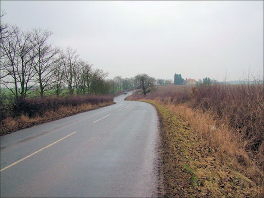
Figure 2: Church Field Road, between Clayton and Hooton Pagnell. Despite the loss of strip enclosure field boundaries either side of this road, their former sinuous shapes have been preserved by this road’s course.
Photo © 2006 Richard Spencer and licensed for reuse under a creative commons license http://creativecommons.org/licenses/by-sa/2.0/
This character zone includes 71% of the rural ancient woodlands in Doncaster2 reflecting the medieval origin of the open field systems underlying its development. Archaeologically, the ancient woodlands of Doncaster Borough are some of the least studied of those within South Yorkshire. As a result, it is probable that they contain more earthwork evidence than is currently represented on the South Yorkshire SMR. Records for these woodlands already include: Bronze Age barrows; Iron Age and Romano-British enclosures; and medieval strip lynchets / ridge and furrow. Evidence for the industrial use of woodlands in this area, so characteristic of the woodlands of Barnsley, Sheffield and Rotherham, is less well recorded.
Woodlands in this zone show a close relationship to the distribution of historic parish boundaries, with many located at the margin of parishes. All but two of the character units identified as Ancient Woodland in this zone intersect with a historic parish boundary – a pattern noticed elsewhere in South Yorkshire (see Jones 1995, 72; 2000, 54-55).
The legibility of this underlying medieval and post-medieval landscape contrasts sharply with that of an earlier landscape, dating to the Iron Age / Romano-British periods (Roberts et al 2007, Chapter 8). This earlier landscape has been sporadically observed and photographed as variations in the colour of ripening crops since the mid 1970s (see for example Riley 1980) and this ephemeral evidence has recently been mapped (Roberts et al 2007).
The present distribution of the remaining traces of this landscape are affected by a number of factors, principally the permeability of the underlying geology, which affects the degree to which crop marks are likely to form (ibid, Chapter 8, p2 and Appendix 3); more freely drained soils are more prone to the conditions under which crops become stressed at time of drought, affecting their growth where there are buried features. Within this zone, the visible crop marks correspond closely to the area underlain by Magnesian Limestone geology. However, the survival of the subsurface features themselves will also affect their distribution. In this zone, the highest concentration of crop marks is in areas where woodland was felled in the twentieth century - at the site of Brodsworth Wood; Marr Moor and Marr Thick (all of which were felled between 1938 and 1966). It is likely that the protection offered by growing trees, until their felling, preserved the features now producing these crop marks, whilst similar features were eroded by ploughing elsewhere.
Later Characteristics
The loss of boundaries that has produced the open character of much of this zone appears, from the characterisation data, to have been most significant in the second half of the 20th century. This process has continued to the present day, as the economies of scale provided to farmers by larger land parcels continue to offer incentives to remove hedges. Acting to counter this trend are incentives offered by the ‘stewardship’ schemes sponsored by central government since the early 1990s. These schemes offer financial incentives to farmers who enter into environmental management agreements, which can include steps to maintain or restore historically characteristic features such as boundaries, buildings, and (under the Environmental Stewardship system in place since 2005) reduce the impact of their activities on known archaeological sites (Rural Development Service 2005, 68-70).
A contemporary development has been the introduction of the Hedgerow Regulations of 1997 (HMSO) which requires the notification of the Local Planning Authority before the removal of a hedgerow in addition to conferring powers on the same authority to serve a Hedgerow Retention Notice where hedgerows can be defined as important in historical, archaeological, wildlife or landscape terms.
Other late 20th/ early 21st century influences on this historic character zone relate largely to the influence of adjacent zones, particularly those which will influence future character change. Most notable is the presence in this zone of the majority of the course of the A1 dual carriageway and part of the course of the M18 motorway west of Wadworth Interchange (itself part of the ‘Post Industrial’ character zone). These routes are generally superimposed on landscape features of earlier origin, although parts of the A1 follow the earlier route of the Great North Road. Their dominant constructional materials are concrete, steel and massive earthen embankments, which generally sever earlier previously coherent landscape units.
Character Areas within this Zone
Map links will open in a new window.
- Clayton-Frickley to Burghwallis Piecemeal Countryside (Map)
- Marr Thick, Melton Wood and Sheep Walks (Map)
- Mexborough to Scawsby Piecemeal Countryside (Map)
- Micklebring to Wadworth Piecemeal Fields (Map)
- Tickhill to Stainton Piecemeal (Map)
Bibliography
- Hall, D.
- 2001 Turning the Plough. Midland Open Fields: Landscape Character and Proposals for Management. Northampton: Northamptonshire County Council and English Heritage.
- HMSO
- 1997 The Hedgerows Regulation (Statutory Instrument 1997 No.1160)
- Jones, M.
- 1995 Rotherham’s Woodland Heritage. Rotherham: Rotherwood Press.
- Jones, M.
- 2000 The Making of the South Yorkshire Landscape. Barnsley: Pen and Sword Books.
- Rackham, O.
- 1986 The History of the Countryside. London: J.M. Dent.
- Riley, D.N.
- 1980 Early Landscape from the Air: Studies of Crop Marks in South Yorkshire and North Nottinghamshire. Sheffield: Dept of Prehistory and Archaeology.
- Roberts, I., Deegan, A., Berg, D. and Ford, L.
- Archaeological Cropmark Landscapes of the Magnesian Limestone. [Unpublished]. Morley: Archaeological Services WYAS.
- Rural Development Service
- Higher Level Stewardship.
- SYAS
- 2005 South Yorkshire Historic Environment Characterisation: revised project design 18th Feb, 2005 [unpublished]. Sheffield: South Yorkshire Archaeology Service.
- Taylor, C.
- 1975 Fields in the English Landscape. London: J.M Dent.
1 89% of the character units within this zone fall within the ‘Enclosed Land’ Broad Type
2 This calculation is based on the character units classified with a Broad Type of “Ancient Woodland”