Extractive Zone
Summary of Dominant Character
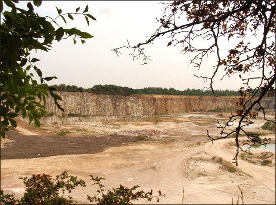
Figure 1: View over Holme Hall Limestone quarry near Stainton.
© SYAS 2006.
The ‘Extractive’ zone contains all quarrying and mining operations still operative in 2003. To the east of the district, between Hatfield and Bawtry, lie concentrations of sand and gravel pits, exploiting the glacial deposits that overlie the Bunter Sandstone. Elsewhere, the colliery sites of Thorne (disused, but at the time of the survey still featuring headgear), Hatfield Main and Rossington Main all exploit the extensive concealed coalfield deposits below the Bunter Sandstone and Magnesian Limestone strata. Further west, the Magnesian Limestone supports a number of large-scale limestone quarries. The character areas making up this zone are often single or small groups of quarries. They have been treated as a separate zone due to the intrusive nature of their relationship to the surrounding landscape. Generally these landscapes date to the mid 20th century or later (although some have evolved from smaller, now illegible extractive sites) and are heavily industrial in character. Access by the general public is typically low, except where former gravel and clay pits have been allowed to flood and converted to amenity uses.
Relationship to Adjacent Character Zones
This zone always is found within or at the edge of enclosed agricultural landscapes, although the coal mines of Rossington, Thorne and Hatfield are also intrinsically related to adjacent ‘Planned Industrial Settlements’. Most of the borough overlies important mineral reserves and as a result extractive landscapes can be found as character islands within ‘Surveyed Enclosure’, ‘Agglomerated Enclosure’ and ‘Wetland Enclosure’ zones. There is a time based relationship between this zone and the ‘Post Industrial’ character zone as there are strong forces of change in the borough acting to promote the reuse of disused extractive zones as recreational and commercial sites.
Inherited Character
The nature of the activities at these sites means that beyond traces of their earlier development as extractive landscapes, previous historic character is invisible, having literally been quarried away. The inherent destruction of earlier evidence that this activity involves often includes the continual removal of earlier phases of work. Therefore, this section will concentrate on a brief history of the extractive landscapes of this zone themselves.
Coal: In 2003, the end date for the characterisation of this landscape, this zone contained three coal mines retaining surface buildings, Hatfield Main, Rossington Main and Thorne Colliery. Of these, Hatfield and Thorne were dormant (with pumping gear kept working, despite day to day coal extraction having ceased) and kept on a ‘care and maintenance’ basis in case of future need. Rossington Main was still in operation as a working mine.
The South Yorkshire coal reserves consist of both an exposed coalfield where seams outcrop at the surface and are consequently easily accessible, and a concealed coalfield where the carboniferous strata (in South Yorkshire the ‘Coal Measures Sandstones’) are overlain by later geological deposits of Permian and Triassic limestone and sandstone. The shallower depth of the most productive seams in the exposed coalfield (most notably the Main or Barnsley Bed seam, from which many collieries gained part of their name) meant that mining was concentrated to the west of the county until the late 19th century (Hill 2002, 16). However, by the end of the 19th century, collieries on the west of the coalfield were beginning to become exhausted and advances in technologies of transport, ventilation and pumping were beginning to make the exploitation of the deeper concealed coalfield a reality. Most of the collieries on the Doncaster coalfield were first sunk between 1905 and 1916 (Gill 2007), with the exception of Cadeby and Denaby Mains, which were sunk earlier as they exploited a natural cutting through the Magnesian Limestone made by the Don Gorge.
The first shafts at Rossington Main Colliery were sunk in 1912 with the mine beginning production in 1916 (Taylor 2001, 105-106). Production finally ceased in March 2006 (BBC News 2006a). Prior to mining, the area formed part of the larger drained wetlands of the ‘Doncaster Carrs’ character area (see ‘Wetland Enclosure’ zone). Early OS maps mark the area as Holmes Carr, with typical regular drained enclosures bounded by ditches shown. The colliery expanded in size largely through the growth of its spoil heaps to the north east and principally to the south. Further effects on the landscape were created by the construction of the accompanying mining village of New Rossington around an older medieval village to the east (described in ‘Planned Industrial Settlements’ zone). During 2003 the colliery was highly legible as a working coal mine with exposed headgear and traditional brick buildings.
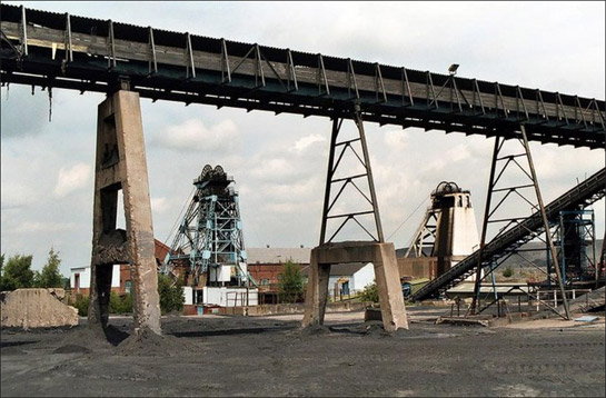
Figure2: Hatfield Main Colliery
© 2004 Alan Murray-Rust and licensed for reuse with a creative commons license. http://creativecommons.org/licenses/by-sa/2.0/"
Hatfield Main Colliery was sunk in 1911 with major investment schemes implemented in 1945-6, 1957 and 1978. However, large losses through the 1980s led to periods of closure from the 1990s (Hill 2001, 213-214) and production finally ceased at Hatfield Main in 2003. Current proposals (BBC News 2006b) to introduce a coal gasification plant would (if successful) reintroduce mining to the pit by 2009. The proposals would involve the demolition of the current above ground buildings and washing of the colliery spoil tips and their replacement with an industrial estate resulting in “dramatic changes to the setting of the surviving pithead elements” (Lakin 2002, 19).
Analysis of Haywood's enclosure award plan of the area (1825) does not suggest Parliamentary enclosure here. The irregularly bounded enclosures shown suggest pre-existing piecemeal enclosure; the expansion of the pit-head and its accompanying spoil heaps appears to have removed all traces of this earlier landscape. Nearby placenames such as Nettleholmes and Carr suggest previous land uses as wetland common. The growth of Hatfield Main fostered the growth of the adjacent ‘Stainforth Colliery Village’ character area (see ‘Planned Industrial Settlements Zone’).
Thorne Colliery was first sunk in 1909, although the sinking process was interrupted by both flooding problems and WWI; production did not begin until 1926 (Hill 2002, 232). The colliery is sited within the area of 'Moorland Allotments' as defined by Miller (1997) to the west of Thorne Moor and created by intake of moorland fringe in the late 18th - early 19th centuries. The construction of the colliery and the accompanying village of ‘Thorne Moorends’ has rendered legibility of this older pattern of enclosure invisible. Thorne Colliery was worked until 1956, although production was often beset by flooding (Taylor 2002, 108).
Despite ceasing production in the 1950s, the mine remained technically open for nearly 50 years longer, with a number of proposals mooted for reopening it, as it has significant unexploited resources. The most recent attempt to restore the colliery was in the early 1980s and saw the demolition of many older buildings and the construction of two modern winding gears (Hill 2002, 233), although this project was halted before completion. The mine continued on a ‘care and maintenance’ basis pending a rise in coal prices and the expected future exhaustion of the Selby coalfield. In 2002 it was proposed, by then owners UK Coal, to seal the shafts and formerly abandon the mine, with demolition of surface buildings and winding gear taking place in 2005.
Minerals: Mineral extraction in this zone can be allocated to two district groups. To the west of the district are major quarries now largely operated for the extraction of limestone and dolomite, in relation to the underlying Magnesian Limestone strata. To the east of the borough, large extractive sites are concerned with the extraction of fine and course aggregates, which are found where there are sizeable areas of glacially deposited sands and gravels.
Limestone quarrying is apparent on a small scale across the district on mid 19th century mapping, particularly around Warmsworth, Cadeby and Sprotbrough in the ‘Don Gorge’ character area and around Hampole (Ford 2007, 25). These early quarries were chiefly involved in the extraction of building stone and the burning of lime for use in agriculture and glass making. The majority of sites of this period either lie outside the present ‘Extractive’ zone or have since been quarried away, as at Warmsworth. The surviving evidence is generally late 20th century in character. During this period the scale of aggregate quarrying in Doncaster experienced dramatic growth. The largest site by 1948 was Levitt Hagg Quarry and Lime Works at c.25 hectares in size. By 2003 the quarries around the Don Gorge alone totalled over 250 hectares; character unit records show the majority as first appearing on 1960s and 1970s OS mapping. Limestone quarries in Doncaster have generally displaced enclosed agricultural landscapes of both piecemeal and surveyed types.
Most active large-scale (over 5 hectares) sand and gravel quarries in this zone date to the second half of the 20th century, although smaller ‘sand pits’ are a regular occurrence on late 19th and early 20th century Ordnance Survey maps, especially close to settlements and enclosure period or turnpike roads. The change in scale of extraction post-1950 probably relates to the increase in road construction and maintenance in the later 20th century, especially works related to the construction of the motorway network.
Later Characteristics
The period during which this project was undertaken (2004-2008) seems to have corresponded with the end of the traditional mining of coal within the borough of Doncaster, with the turning off of the drainage and ventilation systems at Rossington Main and Thorne and transfer of Hatfield Main to ‘Care and Maintenance’ in 2004, pending possible regeneration as a coal gasification station. It is likely that in 5 years time the Rossington and Thorne sites will share the characteristics of the ‘Post Industrial’ character zone. However, Hatfield restarted full production of coal on 2nd January 2008 with reserves projected to last 40 years. Coal is eventually planned to be burned in an on-site power station, at which it is planned to capture 90% of carbon dioxide emissions and then pipe them to former oilfields in the North Sea (Herron 2008).
Character Areas within this Zone
Map links will open in a new window.
- Former Spoil Heap North of Adwick upon Dearne (Map)
- Blaxton / Finningley Quarries (Map)
- Hatfield Colliery (Map)
- Hatfield Sand Quarries (Map)
- Hazel Lane Quarry (Map)
- Holme Hall Quarries (Map)
- Quarry East of New Rossington (Map)
- Rossington Main Colliery (Map)
- Thorne Colliery (Map)
- Warmsworth and Cadeby Limestone Quarries (Map)
Bibliography
- BBC News
- 2006a Coal group closes loss-making pit. BBC News [online]. 31 March. London: BBC.
Available from: http://news.bbc.co.uk/1/hi/england/south_yorkshire/4864376.stm [accessed 2/01/08]. - BBC News
- 2006b New mining prospects for colliery. BBC News [online]. 20 March. London: BBC.
Available from: http://news.bbc.co.uk/1/hi/england/south_yorkshire/4827168.stm [accessed 2/01/08]. - Ford, L.
- 2007 Catalogue of Quarry Sites. In: I. Roberts, A. Deegan, D. Berg and L. Ford, Archaeological Cropmark Landscapes of the Magnesian Limestone. Morley: Archaeological Services WYAS.
- Gill, M.
- 2007 Mines of Coal and other Stratified Minerals in Yorkshire from 1854 [Geo-referenced Digital Database]. Available from: Northern Mines Research Society, 38 Main Street,
Sutton in Craven, KEIGHLEY, Yorkshire, BD20 7HD. - Haywood, J.
- 1825 Hatfield Thorne, Fishlake, Stainforth and Sykehouse Enclosure Award Plan. 12 chains to the inch. Sheffield Archives ref A152/3 (microfilm of original held by Doncaster MBC Archives).
- Herron, M.
- 2008 Mining starts again at pit. The Star [online]. 2 January, 2008. Sheffield: Sheffield Newspapers Ltd/ Johnson Press.
Available from: www.thestar.co.uk/doncaster/Mining-starts-again-at-pit.3633544.jp [accessed 3/01/08]. - Hill, A.
- 2002 The South Yorkshire Coalfield: a History and Development. Stroud: Tempus Publishing Ltd.
- Lakin, M.
- 2002 Hatfield Main Colliery, Stainforth, S. Yorks: Masterplan for Hatfield Colliery Power Park unpublished document. Archaeological Desk Based Assesment by Northern Archaeological Associates for Coal Power Ltd. Report No NAA 02/107.
- Miller, K.
- 1997 The Isle of Axholme Historic Landscape Characterisation Project [unpublished]. Report for the Countryside Commission, Yorkshire and Humber Region, Leeds.
- Taylor, W.
- 2001 South Yorkshire Pits. Barnsley: Wharncliffe Books.