Late 19th to Early 20th Century Villa Suburbs Zone
Summary of Dominant Character
This zone is characterised by the development of housing for purchase by the middle classes. Properties were built semi-detached or detached and display less uniformity than those built either in the ‘Grid Iron Terraced Housing’ or ‘Early to Mid 20th Century Private Suburbs’ character zones. Most properties generally have some level of garden to both the front and rear, the gardens generally aspiring to some degree of landscaping. Streets are often lined with trees and building densities are generally low. The majority of the properties in this zone were developed from the mid 19th century to around 1930. The zone includes two major open spaces: Town Field, a large recreation ground crossed by straight tree-lined avenues; and Elmfield Park, characterised by geometric flowerbeds and curving avenues in addition to tennis courts and bowling greens. Both of these recreational landscapes were created by municipal re-landscaping of existing green spaces depicted on the 1930 25 inch-to-the-mile OS map.
Built character varies across the zone. The earliest area of development was constructed along South Parade before 1851, essentially as ribbon development, and consists of large terraced townhouses, generally of 3 storeys and now generally in commercial use. Accompanying these terraces is Regent’s Square laid out in the early 1850s (Doncaster MBC (a), 12).
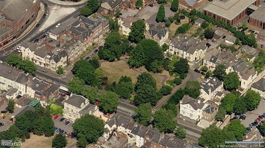
Figure 1: Regent’s Square, Doncaster - a mid 19th century ‘Garden Square’.
Photo © 2007 Microsoft + © 2007 Blom
This is a formal ‘garden square’ of terraced townhouses, mostly fronted in ashlar limestone, surrounding a small enclosed garden. This garden’s surviving design follows a pattern well established in London squares of the same period; the perimeter is planted with trees and shrubs, within which there is a symmetrical walk around a central lawn (Beresford 2003, 7). The construction of Regent’s Square began the speculative development of larger residences on plots of land to the south east of the town centre.
The period between the 1894 and1903 OS maps sees the western end of Thorne Road developed with large semi-detached and detached properties in their own grounds, both as ribbon development along the road itself and along perpendicular plots - such as that in which Avenue Road was built. Houses are a mixture of late Victorian and Edwardian styles, with ornate Gothic and Arts & Crafts details common. Most buildings are of complex construction, featuring multiple building ranges and roof-lines. Later development in this area, particularly the blocks to the east of Town Field, are built to a higher density and display more of the architectural character of the ‘Early – Mid 20th Century Private Suburbs’ character zone, being of more uniform design and generally being of simpler square construction.
The ‘Bawtry Road Villas’ character area was first developed between 1902 and 1930, with large building plots in which large detached residences were constructed, standing in their own grounds - both along Bawtry Road and around the specially laid out St Wilfred’s Road.
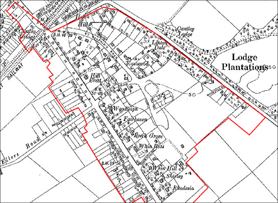
Figure 2: Development of the ‘Bawtry Road Villas’ character area by 1931.
Based on 1931 OS 1:10560 mapping © Sitescope Ltd
Relationships to Adjacent Character Zones
The two character areas of this zone are both within the main Doncaster conurbation, the only settlement in the borough where villa developments have covered large enough areas to be described as character areas in their own right (smaller, more dispersed examples are included within character areas of the ‘Complex Historic Town Core’ zone). As in Sheffield, these areas were consciously developed away from established industrial zones and areas of working class housing. Later suburban development of higher density generally surrounds these character areas.
Inherited Character
In the ‘Bawtry Road’ character area the only features traceable from earlier landscapes are the courses of Bawtry Road and Cantley Lane, within which the villa development was fitted. Earlier field boundaries along these roads were straight edged and probably dated to the enclosure of open fields by the 1779 Cantley, Branton, Bessacarr and (High) Ellers enclosure award (date from English 1985).
The Town Field recreation ground, within the ‘Town Field Suburb’ character area, represents the last area of Doncaster’s former open fields to fall out of agricultural use.
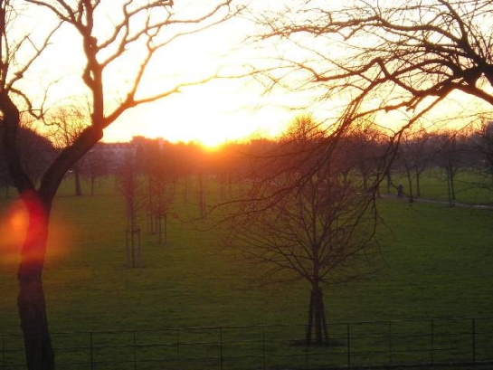
Figure 3: Town Field, Doncaster
© 2005 Anthony Heald and licensed for reuse with a creative commons license. http://creativecommons.org/licenses/by-sa/2.0/
This area was partly farmed in ‘s-curve’ strips, bounded only by stone markers, until 1926 (Braim 1982). Parliamentary enclosure of this field was strongly resisted by townspeople, with the Town Council passing a motion in 1814 that,
“it is not desirable for the Corporation to concur with the other proprietors of Doncaster Field in applying to Parliament for an act to enclose same”(Council Minutes 22nd December, 1814, cited in Braim 1982).
Following the departure of the final tenant farmer from the Town Field in 1922, the land was laid down to grass with the present paths and avenues set out. However, these do not preserve any legibility of the former strip layout or historic paths across the field.
Elsewhere in the ‘Town Field Suburb’ character area patterns of development fossilised boundaries from earlier landscapes. These include the triangle of land on which Christ Church now stands. This large Commissioners Church (built with French War reparations) dates to the period 1827-9 (Pevsner and Radcliffe 1967, 182); its site preserves the exterior boundaries of the north western end of a diamond shaped green. Slater (1989, 57) has suggested this originated at the crossing point of the main north - south Roman road and a lesser, more speculative, Roman road from Long Sandall to Templeborough.
Other legible earlier features in the ‘Town Field Suburb’ character area include the early 19th century Elmfield House, the parkland of which was redesigned in the 1920s, when it became the municipal Elmfield Park.
Later Characteristics
This character area has continued to develop until the present day, with the construction of higher density suburban housing on plots in between those developed before World War II.
Character Areas within this Zone
Map links will open in a new window.
Bibliography
- Beresford, C.
- 2003 The Development of Garden Squares [online].London: English Heritage. Available from: http://www.english-heritage.org.uk/upload/pdf/town_squares.pdf [accessed 11/08/08].
- Braim, E.
- 1982 Town Field. Doncaster Civic Trust Newsletter No 37 [online]. Available from: http://www.the-villager.co.uk/Archives.asp?FILE=20020909012&ACT=LEG [accessed 11/08/08].
- Doncaster MBC
- undated (a) Bennetthorpe Conservation Area Appraisal [online]. Doncaster: Doncaster MBC. Available from: http://www.doncaster.gov.uk/Images/Bennetthorpe%20apprasial%20new%20cover_tcm2-54274.pdf [accessed 11/08/08].
- Doncaster MBC
- undated (b) Thorne Road Conservation Area Appraisal [online]. Doncaster: Doncaster MBC. Available from: http://www.doncaster.gov.uk/Images/Thorne%20RoadAppraisal%20New%20Cover_tcm2-54272.pdf [accessed 11/08/08].
- English, B.
- 1985 Yorkshire Enclosure Awards Hull, University of Hull Department of Continuing Education.
- Pevsner, N. and Radcliffe, E.
- 1967 The Buildings of England. Yorkshire: The West Riding [second edition]. Harmondsworth: Penguin.
- Slater, T.R.
- 1989 Doncaster’s Town Plan: An Analysis. In: P.C. Buckland, J.R. Magilton and C. Hayfield, The Archaeology of Doncaster: 2. The Medieval and Later Town, Part i. [BAR British Series 202(i)] Oxford: B.A.R.