Grid Iron Terraced Housing
Summary of Dominant Character
Barnsley was a relatively small market town up until the 19th century when linen manufacturing and other industries attracted large numbers of people into the town. This influx of population necessitated a substantial expansion over a short period of time and led to the development of large areas of terraced workers housing to the south of the town centre, with the new streets mainly set out in a regular grid iron pattern. The building of terraces to house the workforce was an established tradition in the district of Barnsley, as it was across the country. Many of the early terraces were very small properties within short rows or built around a small courtyard and often included back-to-back houses. It was often not until the late 19th century, when concerns for housing standards were raised, that properties where built to higher standards. Few of the earliest phases of terraced housing survive within Barnsley, as they were demolished in various phases of slum clearance in the 20th century. This zone is largely made up of the later developments of terraced housing, with larger houses and improved living conditions.
Most of the housing within this zone was built in regular grid patterns from the late 19th century into the 1930s. There is generally much similarity of building style within the rows of terraces, but within the zone there is a certain amount of variation. On sloping roads the roofs of the terraces are often built in a continuous run from one end of the street to the other. This differs from Sheffield, where roofs tend to be stepped down along the slope. Many terraces feature a modern rear extension, normally housing a kitchen and bathroom, but some of the larger houses lining the main thoroughfares through Barnsley were built on a grander scale, with a two storey off-shot built as part of the original house.
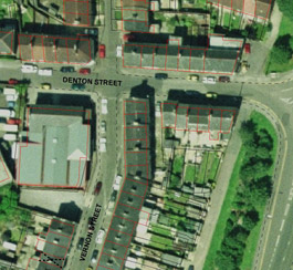
Figure 1: Shared back yard behind houses on the corner of Vernon Street and Denton Street.
Cities Revealed aerial photography © the GeoInformation Group, 2002; OS mapping © Crown copyright. All rights reserved. Sheffield City Council 100018816. 2007
In the 19th and early 20th century, access to the rear of the houses was necessary for emptying the outside toilets. This access was facilitated in a mixture of ways including: shared yards running off the main street; back alleys running the length of the street; and covered passageways running through the terrace to an enclosed rear yard. Sheffield has a tradition of passageway access through terraces, a pattern which has been explained as a continuation of an older practice of constructing domestic ‘courts’ of back-to-back houses (Muthesius 1982). This contrasts with Doncaster, which has mainly alleyway access. The ‘Grid Iron Terraced Housing’ zone within Barnsley has a mixture of these traditions, although there are large numbers of rear alleyways.
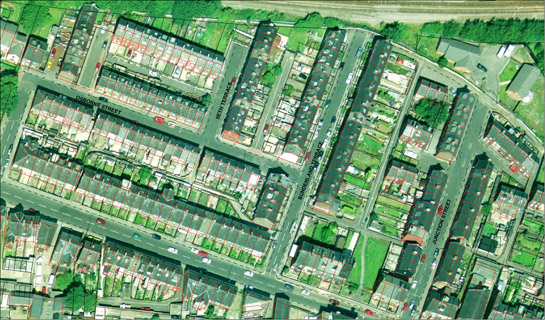
Figure 2: Regular layout of terraces with narrow lanes or alleyways running to the rear of the houses.
Cities Revealed aerial photography © the GeoInformation Group, 2002; OS mapping © Crown copyright. All rights reserved. Sheffield City Council 100018816. 2007
Many areas of housing within this zone contain contemporary institutional buildings, especially churches and schools, although these have often been reused. These areas were also provided with shops and pubs (often on street corners) and land set aside for allotment gardens.
The rapid expansion of these areas of grid iron terraced housing can be clearly seen by comparing the historic OS map editions between 1855 and 1907.
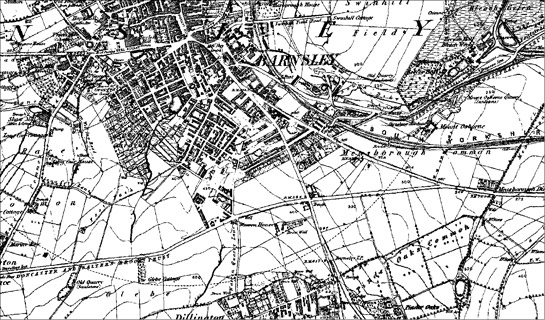
Figure 3: Barnsley 1855.
OS map © and database right Crown Copyright and Landmark Information Group Ltd (All rights reserved 2008) Licence numbers 000394 and TP0024
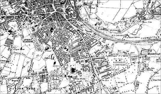
Figure 4: Barnsley 1894.
OS map © and database right Crown Copyright and Landmark Information Group Ltd (All rights reserved 2008) Licence numbers 000394 and TP0024
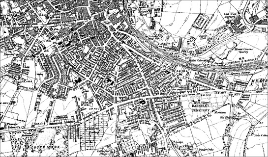
Figure 5: Barnsley 1907.
OS map © and database right Crown Copyright and Landmark Information Group Ltd (All rights reserved 2008) Licence numbers 000394 and TP0024
Relationship to Adjacent Character Zones
Within the district of Barnsley, 552 hectares of terraced housing have been recorded by this project, but less than half of this area is within the ‘Grid Iron Terraced Housing’ zone. Most of the remaining terraces are found within the ‘Industrial Settlements’ zone. These settlements developed from the tradition of colliery rows and there is often little clear structure to the layout of the settlements.
As is typical across many parts of Britain, industrialised in the later 19th century, the development of large areas of terraced housing in Barnsley is closely related to contemporary industries and the need to quickly and affordably build sufficient housing to accommodate workers and their families. Each area of this zone is adjacent to sites of significant industrial employment in the late 19th and early 20th centuries: there were formerly iron works adjacent to ‘Swinhill Terraces’; there was a mix of iron and steel works and textile industries radiating out from Town End; and there was a concentration of industrial sites around the canal basin at Old Mill.
Around Town End the earlier terraces seem likely to have been built up in a piecemeal fashion, possibly by individual industrialists, as the area has a more irregular patterning of streets, with short rows clustered around the former industrial sites.
Around Locke Park and near to Victoria Crescent the houses tend to be larger and more trees line the streets. These areas of terraced housing are slightly further from the sites of 19th and early 20th century industry and have characteristics in common with the grander ‘19th to early 20th Century Villa Suburbs’; as with the villa suburbs, Freehold Land Societies may have been involved in the development of the houses in these areas (see ‘19th to early 20th Century Villa Suburbs’ zone).
Large areas of early terraced housing within Barnsley town were knocked down in the 1960s and 70s. Often these areas are now dominated by council built flats and so fall within the ‘Municipal Suburbs’ zone, or they were redeveloped after the replanning of the urban commercial centre in the 1970s and fall within the ‘Late 20th Century Replanned Centres’ zone.
Inherited Character
To the south of Barnsley town, large areas of common moorland were enclosed as part of the 1779 Parliamentary Enclosure Award (date from English 1985). The regular field patterns created lent themselves to the laying out of large areas of terraced housing and there is clear visibility of these field patterns in the layout of the streets of this zone.
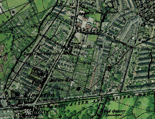
Figure 6: Surveyed Enclosure of Race Common is still clearly shown in the layout of the terraced housing.
1855 OS map © and database right Crown Copyright and Landmark Information Group Ltd (All rights reserved 2008) Licence numbers 000394 and TP0024 overlying Cities Revealed aerial photography © the GeoInformation Group, 2002
West of the town centre there were older field patterns, either from early enclosure of moorland or former woodland or from piecemeal enclosure of parts of the medieval open field. The sinuous road patterns of this older landscape are retained within the town and the strip patterns produced by the piecemeal enclosure of medieval open fields are clearly seen in the long thin strips of land within the allotment gardens off Shaw Lane.
Linen manufacturing was primarily responsible for Barnsley’s rapid increase in population in the first half of the 19th century (Taylor 1993, 25). Many of the warehouses and mills associated with this industry were located around Town End and fall within this zone, as well as within ‘Late 20th Century Replanned Centres’ and ‘Complex Historic Town Cores’. Large numbers of weavers’ cottages were also located south of the town centre. These homes housed up to 6 looms per building and were built and owned by linen manufacturers for renting out to hand loom weavers. The looms were generally placed in a basement workshop as damp conditions made it less likely that the linen would to snap during weaving (Taylor 1995, 42-3).
The weaving cottages within Barnsley have all been demolished. This was often done as part of the housing clearance schemes of the 1960s and 70s, but some areas of early terraces were cleared to allow for new facilities associated with the better terraced housing of the 1930s. These facilities included the Health Centre built by 1938 on an area of former back-to-back housing on New Street in the ‘Shaw Lands and Locke Park’ character area. Extensive redevelopment has meant that most of the areas of former weavers’ cottages lie within the ‘Late 20th Century Replanned Centres’ zone and within ‘Municipal Suburbs’. Around Doncaster Road, however, an area of former weaving cottages retains its street plan and some of the better quality terraced housing survives.
Surviving elements of the textile industry within the zone are represented by a small textile mill on Shaw Lane and the former velvet works on Pond Street. There is very little legibility of the other former mill sites and warehouses within this zone, as they have since been over built. Generally a continuation of the earlier road pattern is all that survives.
The linen industry went into decline in Barnsley from the mid 19th century, as the industry failed to adapt to increased mechanisation (Jones 2000, 59). However, there were numerous other working opportunities for the population of Barnsley. The rapidly increasing coal industry drew in many of the former male weavers as did the local iron foundries and glassworks. Within this zone are some surviving buildings associated with the Yorkshire Metal Works at Swinhill and the site of the former Victoria iron foundry, which was first marked on the 1893 OS map, but which was replaced by terraced housing in the 1930s.
Later Characteristics
As with most urban areas, there are various examples of late 20th century infilling throughout this zone. Commercial properties and private housing estates are the most common new developments. These have been built on a variety of different former landscape types (see chart below).
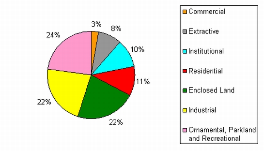
Figure 7: Chart showing the previous landscape character types of areas of late 20th century infill found within the ‘Grid Iron Terraced Housing’ zone. (Percentage of land by area).
Ornamental, Parkland and Recreational landscapes are the most common type to be affected by modern development. These predominantly consist of former allotment gardens, although part of the 19th century public baths also falls within this category. The decrease in demand for allotments in the late 20th century has seen large areas throughout the region revert to scrub or disappear through development pressures. Remnants of agricultural land have also been affected by this urbanising pressure. In contrast to this movement towards a more built up environment, the former extractive sites within this zone have been landscaped and converted to parks and recreation grounds in the late 20th century. These sites were mostly clay pits and brickworks that would have been instrumental in providing materials for the construction of brick terraces in Barnsley. The new green spaces created, however, are smaller than the areas of open and recreational land that have been removed.
Institutional sites have also been overbuilt with modern housing. Within this zone these were mostly small school sites contemporary with the surrounding terraces; the schools having been replaced by larger more centralised schools in the late 20th century. Where school buildings have not been demolished, they have often been reused as community centres, clubs or youth centres.
Mid to late 20th century infilling on sites of former residential development consists of a mix of modern private housing and small commercial developments. Often it is the older terraced houses that have been knocked down and replaced, but this has only occurred on a small scale within this zone. This mix of commercial and private residential redevelopment has also occurred on some of the small industrial sites contemporary with the development of the terraced housing that fall within this zone.
Character Areas within this Zone
Map links will open in a new window.
- Doncaster and Cemetery Road Terraces (Map)
- Old Mill Terraces (Map)
- Pog Moor to Victoria Crescent (Map)
- Shaw Lands and Locke Park (Map)
- Swinhill Terraces (Map)
- Wakefield Road Terraces (Map)
Bibliography
- English, B.
- 1985 Yorkshire Enclosure Awards. Hull: University of Hull.
- Jones, M.
- 2000 Destination Barnsley: The migration History of a Linen Weaving Family, 1798-1932. In: B. Elliott (ed.), Aspects of Barnsley 6. Barnsley: Wharncliffe Publishing, 47-66.
- Taylor, H.
- 1993 Bleachworks of Barnsley and their Industrial Archaeology. In: B. Elliott (ed.), Aspects of Barnsley. Barnsley: Wharncliffe Publishing, 25-61.
- Taylor, H.
- 1995 Taylor Row and the Handloom Weavers of Barnsley. In: B. Elliott (ed.), Aspects of Barnsley 3. Barnsley: Wharncliffe Publishing, 39-64.
- Muthesius, S.
- 1982 The English Terraced House. New Haven: Yale University Press.