Surveyed Enclosure
Summary of Dominant Character
This zone is characterised by land enclosed by straight-sided walls or hedgerows laid out in a regular pattern. Roads within this field pattern are often straight and of a standard width (Hindle 1998) and any woodland is mostly plantation, either planted as part of the surveyed layout, or planted later within existing surveyed boundaries. Surveyed enclosure mostly dates to the 18th and 19th centuries, but there are also more modern areas of straight-sided enclosure, which are also included within this zone.
The majority of the zone consists of former moorland on the higher land in the west of the district, which was enclosed in the 18th and 19th centuries - often under the authority of a parliamentary award. Further east, much more of the land was already enclosed by the 18th century, so here the areas of surveyed enclosure are smaller and represent the enclosure of isolated commons.
The process of enclosing areas of common moorland and communally farmed open fields had started long before the 1700s (Hey 1986, 192). When carried out by the agreement of the local population this often led to the development of piecemeal, irregular enclosure patterns (see the ‘Assarted Enclosure’ and ‘Strip Enclosure’ zones). By the 18th century the call by large landholders to enclose land was supported by parliament; where owners of three quarters of the land in question agreed, an Act could enforce their wishes upon the minority (ibid, 193). This often meant that the poorest farmers fared badly. This division of the newly enclosed land was the creation of a surveyor’s drawing board and led to a very regular field pattern.
Farmsteads within this zone generally align with the field pattern, indicating they are of a contemporary or later date. This is supported by the fact that their plan form principally corresponds to the ‘courtyard’ plan type. Characterisation of farmsteads in Yorkshire has revealed that farms based around regular planned courtyards “were most commonly developed on arable-based farms established as a result of enclosure from the later 18th century” (Lake and Edwards 2006, 44).
The areas of modern enclosure within this zone date to the mid to late 20th century and are usually the result of reinstatement of land to agricultural use after opencast coal or clay working or deep shaft coal mining. The Middle and Lower Coal Measures make up most of the geology of Barnsley and a number of coal seams run close to the surface; these became the focus for attention of the Directorate of Opencast Mining from the Second World War (Gray 1976, 41). Running through the Coal Measures bedrock are also rich seams of clay that have been utilised for pottery and brick production over many years. Since the mid 20th century these resources have been extracted on a large scale in opencast pits. After their reinstatement, there are broad similarities between some of these areas and earlier areas of surveyed enclosure. The main difference lies in the nature of the hedgerows that divide up the land. The hedges on modern enclosures are less mature and contain fewer trees than those on earlier enclosures. There are sometimes small plantations along the edge of the fields, which were probably planted at the time of the mineral extraction to mask the works from nearby roads and houses. In a few places these modern enclosures are similar in character to the older irregular assarts, but the dividing hedgerows tend to be less species rich and to be slightly more regular in form when compared to their ancient equivalents.
Relationships with Adjacent Character Zones
At its western limits the ‘Surveyed Enclosure’ zone stretches into the ‘Moorland’ zone, along the river valleys. In most places there is a clear change between the improved farmland and the open moorland, but some enclosed fields are reverting to a moorland type.
Areas of ‘Surveyed Enclosure’ become more fragmented further east and intermingle with the ‘Strip Enclosure’ and ‘Piecemeal Enclosure’ zones, where the land was often enclosed at an earlier date. There were more areas of surveyed enclosure in the east of the district, but the suburbs of Barnsley and of industrial settlements have mostly over built these.
Inherited Character
The areas of parliamentary enclosure within this zone represent a large-scale systematic programme of landscape change. This process involved dramatically altering the character of the area in social as well as physical terms, as the common resource of the heather moors was transformed into managed grasslands that were only accessible to their owners and tenants. The physical transformation of the land involved, for the most part, a complete change from what was already present. In some areas the newly enclosed land was ploughed for the first time (Taylor 1975, 143) and where lime was added to the soil this altered the plant species that could grow there.
Where parliamentary enclosure was of moorland there is generally little evidence of earlier landscapes. However, in the west of the zone there are small areas of land reverting to moorland plant types after the abandonment of grazing.
Where isolated commons were enclosed by parliamentary award, such as at Barugh Common west of Barnsley town, it is sometimes possible to make out the limits of the earlier common. These are visible as sinuous or irregular boundaries at the edge of the enclosed area.
A small proportion of surveyed enclosure within the district of Barnsley was created by the division of former open fields. These were large fields that surrounded a nucleated settlement and were divided into unhedged strips that were “individually owned but farmed in common” from the medieval period onwards (ibid, 71). In many cases, Ordnance Survey mapping still shows former open field names, although they are associated with a number of modern land parcels (Oliver 1993, 56). Parliamentary enclosure of these areas gives a more complex pattern of historic legibility than the former moorlands. An example of this can be seen at Hunshelf, where there is a mixture of straight and curving boundary features, medieval farm buildings and sinuous roads amidst the surveyed enclosure. A pattern of older roads is also seen south of Kexbrough.
At ‘Gunthwaite Park’ and ‘Tankersley Deer Park’ the picture is even more complex. Both of these sites developed as private parkland, Tankersley in the 14th and Gunthwaite in the 15th century. These were two of a number of medieval deer parks in the district (see ‘Private Parkland’ zone), which provided venison, grazing for cattle or sheep and timber – as well as being a symbol of status for their owners. By the 19th century both parks had fallen out of us. Both were turned over to farmland, although Tankersley was also exploited for the ironstone that is prevalent in the area (Jones 1995). Although not part of a parliamentary award, the date of the enclosure of these parks means that enclosure generally took the form of regular straight-sided fields. The extent of the former park is visible through surviving boundary features and, at Gunthwaite, buildings associated with the medieval hall. Within the Gunthwaite Park area there are also hints of an even earlier landscape, as the slight curving of some field boundaries suggests this land may have been part of the Ingbirchworth open field.
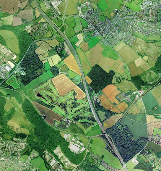
Figure 1: Tankersley Deer Park showing the curving former park boundary and 18th and 19th century regular surveyed enclosure, with the M1 cutting through it.
Cities Revealed aerial photography © the GeoInformation Group, 2002
In contrast to the complex histories visible in the surveyed enclosure of former parkland are the histories visible in the surveyed enclosure on former extractive sites, such as ‘Kexbrough and Cawthorne Former Mineworks’, ‘Kexbrough Modern Enclosures’ and ‘Wombwell Main’. After the closure of areas of opencast clay or coal mining the land is reinstated with new field boundaries that tend to be regular and straight. However, around Cawthorne there are areas where new field boundaries have been created along the same boundary lines that existed prior to mining, giving the impression of an ancient landscape. The key difference is that these hedges tend to less diverse than true ancient hedges, with fewer mature trees. Where reinstatement of the land has been successful there is often no clear sign of the former opencast mining itself.
Later Characteristics
As with the moors to the west, a number of 19th and early 20th century reservoirs and associated waterworks fall within this zone - in the steeper valleys in the north west of the district. Several of the reservoirs have taken on recreational functions as fishing lakes or places to watch birds. These activities have brought car parking and concrete paths to the sites. Taking advantage of these recreational uses is the Scout Dike Outdoor Education Centre, adjacent to Scout Dike Reservoir. This centre developed on a site used by the US army in the Second World War for amphibious training (Council for British Archaeology 2006, Non Anti Invasion Record: 1410).
Transportation routes have also had a significant impact. As the industries of Barnsley developed, large numbers of railway lines were laid across the landscape cutting across surveyed enclosures, as well as earlier features. Around ‘Wombwell Main’ the course of dismantled mineral railways are still preserved in the landscape; although the tracks have been removed the earth banks, with their tree lined sides, stay as clear reminders of this former industrial use. In places these routes have helped the regeneration of the landscape as a recreational amenity; this is seen at ‘Dunford Bridge’ where former railway lines are now part of a well-developed cycle trail.
The continuing effect of transportation is seen in the construction of roads though the district that affect areas of surveyed enclosure. The M1 motorway cuts through part of this zone, as do other modern duel carriageways. These new roads generally sever earlier previously coherent landscape units. The gentle curves of roads that allow traffic to move at speed are in direct contrast with the straight lines of boundaries and roads within this zone.
Character Areas within this Zone
Map links will open in a new window.
- Barugh Former Commons (Map)
- Dunford Bridge (Map)
- Enclosed Moors North of Penistone (Map)
- Gunthwaite Park (Map)
- Hood Green Open Cast (Map)
- Kexbrough and Cawthorne Former Mineworks (Map)
- Kexbrough Modern Enclosures (Map)
- Langsett to Hunshelf Former Moors (Map)
- Lundwood Enclosures (Map)
- Penistone East Enclosed Commons (Map)
- Reservoirs around Ingbirchworth (Map)
- Staincross and Royston Commons (Map)
- Tankersley Deer Park (Map)
- Wombwell Main (Map)
- Wombwell Surveyed Enclosures (Map)
Bibliography
- Bevan, W.
- 2003 The Upper Derwent: Long-term Landscape Archaeology in the Peak District. Thesis (PhD) [online]. University of Sheffield. Available from: http://ads.ahds.ac.uk/catalogue/resources.html?bevan_phd_2005 [accessed 25/05/07].
- Council for British Archaeology
- 2006 The Defence of Britain Database [online]. Available from: http://ads.ahds.ac.uk/catalogue/resources.html?dob [accessed 20/02/08].
- Gray, G.D.B.
- 1976 The South Yorkshire Coalfield. In: J. Benson and R.G. Neville (eds.), Studies in the Yorkshire Coal Industry. Manchester University Press, 31-44.
- Hey, D.
- 1986 A Regional History of England: Yorkshire From AD 1000. London: Longman.
- Hindle, P.
- 1998 Roads that ramble, and roads that run. British Archaeology, 31 [online]. Available from: http://www.britarch.ac.uk/ba/ba31/ba31feat.html [accessed 20/02/08].
- Jones, M.
- 1995 Ironstone Mining at Tankersley in the Nineteenth Century for Elsecar and Milton Ironworks. In: B. Elliott (ed.), Aspects of Barnsley 3. Barnsley: Wharncliffe Publishing, 80-115.
- Rackham, O.
- 1986 The History of the Countryside: The Classic History of Britain’s Landscape, Flora and Fauna. London: Orion Books.
- Taylor, C.
- 1975 Fields in the English Landscape. London: J.M. Dent and Sons Ltd.
- 2006 Historic Farmsteads. Preliminary Character Statement: Yorkshire and Humber Region. Cheltenham: University of Gloucester/ English Heritage/ Countryside Agency.
- Oliver, R.
- 1993 Ordnance Survey Maps: a Concise Guide for Historians. London: Charles Close Society for the Study of Ordnance Survey Maps.