Moorland
Summary of Dominant Character
This zone lies to the west of Barnsley, where a narrow finger of the district reaches into the Peak District National Park. The zone is positioned on an underlying geology of Millstone Grit and ranges from 500 m AOD at its western edge to 300 m AOD where the moors meet adjacent areas of enclosed farmland to the east. There are numerous steep-sided valleys or cloughs cutting through the moors, transferring water to the River Don.
The vast majority of the zone lies within the Peak District National Park and is part of the Dark Peak Landscape Character Area (Countryside Commission 1998, 111-115), which has a “[w]ild and remote semi-natural character created by blanket bog, dwarf shrub heath and heather moorland with rough grazing and a lack of habitation” (ibid, 111). Modern moorland management practices and controlled burning of strips, in order to encourage habitat suitable for red grouse, have lead to a complex mosaic pattern when viewed from the air.
Whilst classified by the Historic Environment Characterisation project as ‘Unenclosed Land’, as the majority of this area has no obvious internal boundary features, this area was generally subject to Parliamentary Enclosure and long drystone walls were built across the landscape to indicate ownership at that time.
Relationships with Adjacent Character Zones
For the most part, there is a clear change of landscape where open moorland meets the improved pastures of the Surveyed Enclosure zone. Some small intakes of land have been grouped within the Moorland zone but often land on one side of a drystone wall sharply contrasts with land on the other.
Inherited Character
The prehistoric landscape of the upland moors is thought to have been quite different from the current heather dominated moors. Environmental evidence, principally taken from the analysis of regional pollen sequences, indicates that following the retreat of the ice at the end of the last Ice Age, a mosaic of woodlands, scrub and grassland developed with open woodland cover extending even to the high moors (Bevan 2003, Chapter 2, 3). Some naturally open areas within the denser vegetation would have resulted from natural processes of lightning strike fires, tree falls, gales and wild grazing. These may well have been attractive to Mesolithic hunter-gatherer populations, as a result of their attraction to important game resources such as red deer (ibid, Chapter 2, 7).
Occupation of upland areas during the Mesolithic (attested to by many find-spots of Mesolithic tools recorded on the South Yorkshire Sites & Monuments Record) was probably seasonal - with visits made to this zone at a time when it was particularly rich in resources (Barnatt and Smith 2004,12). A significant cultural and economic horizon has been detected during the Mesolithic, represented by changes in the flint toolkits being used (ibid, 12); an increasing specialisation and localisation of tool types has been interpreted as an indication of more restricted seasonal patterns of movement. Associated with this change is evidence for increased clearance of woodland, probably by fire. This process is likely to be connected with the initial formation of blanket bog; as trees were removed from the landscape there would have been a reduction in transpiration rates, resulting in waterlogging of the thin soils (Bevan 2004, 32). The rate at which areas of blanket bog grew and the relative importance of human influence and climatic change on this process remain somewhat controversial subjects; current inadequacies in regional pollen sequences make definitive answers to these questions difficult. It seems likely, however, that the earliest areas to lose their tree cover would have been the highest points of the moors.
There is little known of the later prehistoric use of these moors. There is no known evidence for Neolithic occupation within the zone, although this may, in part, be due to the difficulties involved in separating flint tools of the late Mesolithic and early Neolithic; the tools of these periods had similar forms (Bevan 2003, Chapter 2, 12). Any introduction of domesticated species into this zone during the Neolithic period is unlikely to have been accompanied by a dramatic cessation of either earlier hunting practices or seasonal patterns of movement (Bevan 2004, 33). New practices, such as the deliberate keeping, breeding and droving of animals, were probably integrated into an existing seasonal round. Changes to the overall character of the landscape as a whole may well have been imperceptible to individual generations.
Further south, within Sheffield’s Moorland Zone, there is good evidence for farming and settlement in the Bronze Age, within a relatively open and part wooded landscape (Long et al 1998, 516). No comparative cairn (clearance) fields or related monuments are known within Barnsley district; this may be because there is a lack of suitable plateaus on the Barnsley moors.
Regional pollen sequences show a dramatic drop in the remaining woodland cover from the middle Iron Age onwards. After this point, pollen sequences are dominated by open grassland and moor species (Bevan 2003, Chapter 4, p9-10), representing the development of an open moorland landscape that has continued to this day.
Later Characteristics
There is no evidence that the moors themselves were settled in the medieval period but they would have been an important resource for the inhabitants of the valleys below. The moors were generally seen as a resource held ‘in common’, meaning not that they were owned by all but that certain groups held traditional rights to graze animals and gather resources such as bracken, for thatch and bedding, and heather and peat for fuel (Bevan 2004, 89). Parish boundaries in the 19th century show that large parts of the Barnsley moors were detached portions of Cartworth, Hepworth and Austonley parishes; these settlements were located in the valleys north of the moors, in what is now West Yorkshire. This division of resources in the 19th century is likely to be the continuation of earlier practices.
The 18th and 19th centuries saw changes in the established practices of the utilisation of common land. Large areas of moorland and other common land were enclosed and the land improved for use as pasture, under the authorisation of parliamentary enclosure awards (see ‘Surveyed Enclosure’ zone). In many areas of open moorland, parliamentary enclosure was largely a conceptual change rather than a process of physical enclosure. The process generally involved:
“the removal of communal rights, controls or ownership over a piece of land and its conversion into ‘severalty’, that is a state where the owner had sole control over its use, and of access to it.” (Kain et al 2004, 1).
Parts of this zone were enclosed in the early 19th century. For example, in 1830 John Spencer-Stanhope of Cannon Hall acquired around 1,000 acres of recently enclosed land near Dunford Bridge, which he used for grouse shooting (Sykes 1996, 195). The physical manifestations of this enclosure of land are: walls enclosing the edges of the moors (designed to keep people out, rather than livestock in), grouse butts and the strips where controlled burning maintains the low heather needed for grouse. Without this management practice, much of the high moors could be expected to develop, over time, as birch scrub woodland (Bevan 2004, 126).
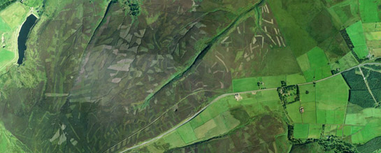
Figure 1: Strips produced from controlled burning of heather, south east of Dunford Bridge.
Cities Revealed aerial photography © the GeoInformation Group, 2002.
The enclosure of moorland for grouse shooting had an affect on the numbers of sheep it was possible to maintain on former common land. Sheep farming and woollen manufacturing were important in western Barnsley from the medieval period until the early 20th century, when the industry declined. However, the enclosure period did produce local gentlemen farmers in this region interested in maintaining the Penistone sheep breed. In the 19th century, tenants of the Spencer-Stanhope’s maintained eight flocks in this area (Sykes 1996, 192-5).
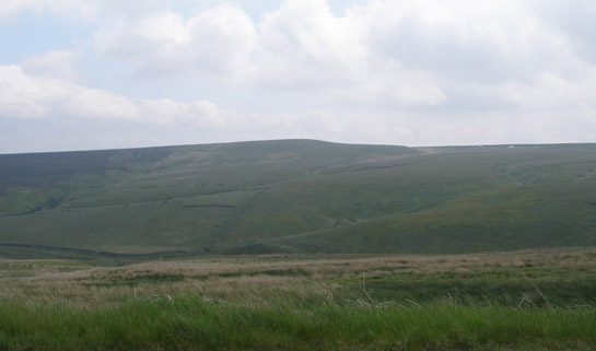
Figure 2: Drystone walls running across unimproved land on Thurlstone Moors.
© SYAS
The A616 runs across the centre of the Barnsley moorlands towards Glossop and Manchester. The course of the modern road was established in 1830, altering a long established route whose original course survives just south of the modern road as a track. This was “the most important highway across the Pennines in South Yorkshire” (Hey 1979, 61) and this segment of it was turnpiked in 1741 (ibid, 61), before many other roads in the area.
The highway has more ancient origins and formed part of a wide network of salt related routes across the country. The processing and transportation of salt was well established in England by the Anglo-Saxon period (Raistrick 1973, 197-8) and the dating of local placename ‘Saltersbrook’ to the 11th or 12th century (Smith 1961, 342) puts the origins of this road back to at least the medieval period. This is one of a number of salt placenames within Barnsley and South Yorkshire, the trade route running east towards Doncaster and branching off into Sheffield. Within this zone, a surviving medieval feature on this path is the remains of Lady Cross, a stone marker recorded in 1290, that marks the limits of land granted to the Cistercian abbey of Basingwerke by the lord of Glossop (Hey 1979, 62, 85). This is an early example of boundary marking that was to take on a more explicit form in the 18th and 19th centuries.
Significant modern influences on the historic landscape of this zone reflect the influences of the nearby urban populations. Population in this region began to grow in size exponentially from the 17th century onwards (Pollard 1956, 172), creating an increasing demand for resources such as water, minerals and open space for recreation. Throughout the zone, reservoirs fill the valley bottoms and in the north earthworks from flag and slate quarrying, although weathered, assert a clear visual impact on the landscape.
Recreational influences are most apparent in the management of the moors by the Peak District National Park, set up in 1951 in order to “conserve the character of the Peak District landscapes and to enable visitors to enjoy them” (Barnatt and Smith 2004, 136). The foundation of the National Park, the first in the UK, was in part a tacit acknowledgement of growing claims that private land needed to be used as wider recreational and cultural amenities. These claims were brought to the fore in the Peak District by direct action by campaigning groups of ramblers, such as the British Workers Sports Federation (Bevan 2004, 164-167), which culminated in the mass trespass of Kinder Scout in 1932.
Such groups often based their claims for access to the moors on detailed studies of history and archaeology, helping them to write a history of ‘common’ access in order to legitimise their contemporary claims (often fiercely resisted by landowners and tenants). A legal right of access was finally established in the 2000 Countryside and Rights of Way Act.
Public access to the zone, since the establishment of the National Park, has brought its own lasting physical changes to the landscape, notably the provision of car parking facilities, hard wearing footpaths and signposts – as well as more intangible and potentially temporary intrusions such as traffic, pollution, litter and vandalism. These features are particularly common around the reservoirs, which have become sites for fishing and water sports.
Character Areas within this Zone
Map links will open in a new window.
- Barnsley Moorland (Map)
- Western Reservoirs (Map)
- Barnatt, J. and Smith, K.
- 2004 The Peak District: Landscapes Trough Time. Macclesfield: Windgather Press.
- Bevan, W.
- 2003 The Upper Derwent: Long-term Landscape Archaeology in the Peak District. Thesis (PhD) [online]. University of Sheffield. Available from: http://ads.ahds.ac.uk/catalogue/resources.html?bevan_phd_2005 [accessed 25/05/07].
- Bevan, B.
- 2004 The Upper Derwent: 10,000 Years in a Peak District Valley. Stroud: Tempus Publishing Ltd.
- Hey, D.
- 1979 The Making of South Yorkshire. Ashbourne: Moorland Publishing.
- Kain, R.J.P., Chapman, J., and Oliver, R.R.
- 2004 The Enclosure Maps of England and Wales. Cambridge: Cambridge University Press.
- Long, D.J., Chambers, F.M. and Barnatt, J.
- 1998 The Palaeoenvironment and the Vegetation History of a Later Prehistoric Field System at Stoke Flat on the Gritstone Uplands of the Peak District. Journal of Archaeological Science, 25, 505-519.
- Pollard, S.
- 1956 The Growth of Population. In: D.L. Linton (ed.), Sheffield and its Region: A Scientific and Historical Survey. Sheffield: British Association for the Advancement of Science.
- Raistrick, A.
- 1973 Industrial Archaeology. London: Grafton Books.
- Smith, A.H.
- 1961 The Place-Names of the West Riding of Yorkshire. The Wapentakes of Lower & Upper Strafforth and Staincross. Cambridge: Cambridge University Press.
- Swanwick, C. and Stedman, N.
- 1998 Countryside Character, Volume 3- Yorkshire and the Humber. London: Countryside Commission.
- Sykes, S.
- 1996 Shepherds, Sheep and Gentlemen: Penistone Moorland Agriculture in the Early Nineteenth Century. In: B. Elliott (ed.), Aspects of Barnsley 4. Barnsley: Wharncliffe Publishing, 189-214.