Wetland Enclosure
Summary of Dominant Character
This zone is characterised by low-lying alluvial landscapes. The vast majority of the zone consists of enclosed landscapes, although within this there are often large areas of fairly open land with few divisions. Parts of the zone contain regular drainage ditches. These areas are often under arable cultivation, although some are utilised as areas of pasture. Where there have not been drainage programmes the land is marshy and wet with scrubby vegetation growth.
This zone predominantly lies within the historic floodplain of the river Dearne, with outlying areas on the river Don, Dove and along smaller dikes south east of Royston. This pattern is due to the differing topographies of the rivers within the Barnsley district. The Dearne has a wide, low flood plain that has been too wet for sustained arable agriculture in the past. The river Don, however, is characterised by steep-sided narrow valleys, with only very small areas of floodplain.
There are broad differences in the period and type of enclosure within this zone. There are areas of largely unimproved land with possible medieval enclosure patterns; other areas were enclosed in the 18th and 19th century. In the south east of the district there was substantial boundary removal in the late 20th century.
Within the ‘Lower Dearne Valley Ings’ there are numerous straight-sided enclosures that probably originated with parliamentary awards. Parliamentary enclosure is characterised by land enclosed with straight-sided walls or hedgerows laid out to a regular pattern. Roads within the field pattern are often straight and of a standard width (Hindle 1998). By the 18th century many large landholders were calling to enclose formerly open land. Where owners of three quarters of the land in question agreed, an Act of Parliament could enforce their wishes upon the minority landholders (Hey 1986, 193).
The enclosure of meadow is mentioned in the Bolton Upon Dearne parliamentary award (English 1985, 20). Although not mentioned specifically in the surrounding enclosure awards, the plan form of the field boundaries in these areas suggests that they were included in parliamentary or contemporary ‘agreed’ enclosure schemes.
Ings (a term used for low lying pasture or meadow land) were frequently included in the classes of land enclosed by Act of Parliament. This, along with the frequency of straight-sided enclosure in locations with ‘Ing’ place names throughout the borough, is strong evidence that meadow was generally a resource held in common in the medieval period.
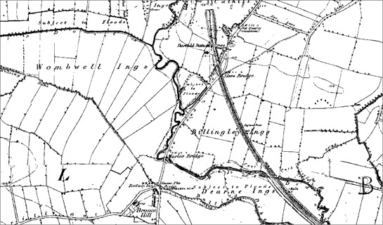
Figure 1: Dearne Valley ‘Ings’ south of Darfield, showing highly regular enclosures, as marked on first edition (1854) OS map
© and database right Crown Copyright and Landmark Information Group Ltd (All rights reserved 2008) Licence numbers 000394 and TP0024
Relationships with Adjacent Character Zones
Where the Dearne valley floor runs through the urban zones of Barnsley town the landscape has been recorded as part of the ‘Sub-Rural Fringe’ zone. This is due to the strong influence of the adjoining urban area on the land here; an example of this influence is the development of areas of public parkland with resultant landscaping and footpath creation. There is, however, significant overlap in character between the ‘Sub-Rural Fringe’ and ‘Wetland Enclosure’ zones, as many sub-rural areas retain relict enclosure boundaries.
There are often significant similarities in boundary pattern between areas of former meadow land that has been enclosed and adjacent areas of ‘Surveyed Enclosure’. Drainage features are often laid out in a regular pattern along straight field boundaries, creating a landscape similar to the regular enclosures of the ‘Surveyed Enclosure’ zone.
Some areas of flood plain are recorded within the ‘Post Industrial’ zone. These include areas of former coal extraction, where mining has ceased and the area has been landscaped, such as at he Old Moor Wetland Centre. Such areas often adjoin the ‘Wetland Enclosure’ zone.
Inherited Character
As noted above, the valley floor area is dominated by Ing place names e.g. Bolton Ings, Billingley Ings, Wombwell Ings and Darfield Ings. This derives from ‘Eng’, meaning “meadow, water-meadow, [or] pasture” (Smith 1962, 183). In the medieval period, meadow is considered to have been an essential part of the mix of farmland. Rackham (1986, 332) describes it as providing winter feed for animals during the months when pasture grasslands (kept for grazing) were less productive. In areas of arable production, like much of the east of the Barnsley district, this feed was largely for animals kept for motive power. Flood plains were eminently suitable for hay making as their propensity to flooding made them simultaneously unsuitable for arable cultivation and highly fertile, due to regular deposits of alluvium. Little of this meadowland character survives.
Later Characteristics
The industries of Barnsley have visibly impacted on this zone through the development of transport links, such as the mineral railways that ran through ‘Lower Dearne Valley Ings’ and along the edge of ‘Carlton Marsh’. These lines have since been removed but associated earthworks preserve their routes.
Prior to the development of the railways, an important transport mechanism in the area was the canal system. Plans for the Barnsley Canal and the Dearne and Dove Canal were given approval in 1793. Both of the canals were instigated by local industrialists to open up new markets for coal and iron. Problems of subsidence and competition from the railways finally caused the closure of these canals in the mid 20th century and led to much of the courses of the canals silting up (Glister 1995; Glister 1996). The best surviving traces of the canal system within this zone are within ‘Upper Dearne Valley Ings’, where both wet and dry courses are visible in the landscape.
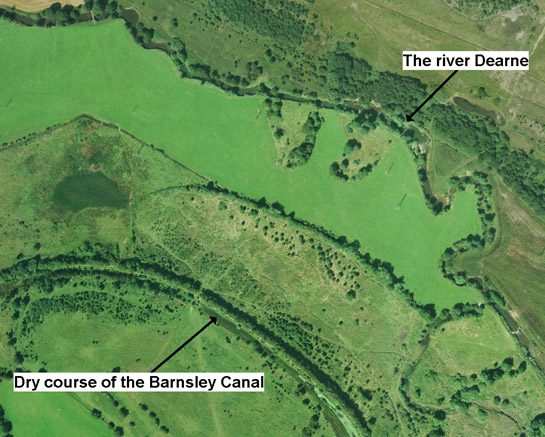
Figure 2: Aerial photograph showing the course of the Barnsley Canal as it runs through the Dearne Valley south of Staincross.
Cities Revealed aerial photography © the GeoInformation Group, 2002.
Boundary loss has impacted on many of the rural character zones within Barnsley district in the late 20th century. The ‘Wetland Enclosure’ zone is no exception to this and, as with other zones this loss is more prevalent in the east of the district.
The ‘Lower Dearne Valley Ings’ have suffered significant boundary removal through agricultural intensification of drained lands. In recent years there have been concerns over the environmental consequences of the drainage of wetlands and the subsequent wildlife habitat loss. This, alongside plans to regenerate former industrial areas close to the ‘Wetland Enclosure’ zone, has led to the establishment of a number of nature reserves.
Character Areas within this Zone
Map links will open in a new window.
- Carlton Marsh (Map)
- Lower Dearne Valley Ings (Map)
- Oxspring Valley Floor (Map)
- Upper Dearne Valley Ings (Map)
- Worsbrough Dale Flood Plain (Map)
Bibliography
- English, B.
- 1985 Yorkshire Enclosure Awards. Hull: Department of Adult Education, University of Hull.
- Glister, R.
- 1995 The Dearne and Dove Canal. In: B. Elliott (ed.), Aspects of Barnsley 3. Barnsley: Wharncliffe Publishing, 116-132.
- Glister, R.
- 1996 The Conception and Construction of the Barnsley Canal. In: Elliot B. Elliott (ed.), Aspects of Barnsley 4. Barnsley: Wharncliffe Publishing, 215-114.
- Rackham, O.
- 1986 The History of the Countryside. London: Dent.
- Smith, A.H.
- 1962 The Place-Names of the West Riding of Yorkshire: Part VII. Cambridge: Cambridge University Press.